
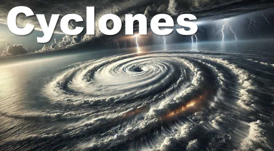
Tropical Cyclone
- Tropical Cyclones are violent storms that originate over oceans in tropical regions.
- They generally develop between 5° and 20° latitudes in both hemispheres.
- These storms involve irregular wind movements with a closed circulation of air around a low-pressure centre.
- Tropical cyclones differ in:
- Shape
- Size
- Velocity
- Weather conditions
- The characteristic whirling motion of air is caused by the rapid upward movement of hot air, which is then affected by the Coriolis Force.
Features of Tropical Cyclone
1. Size of Tropical Cyclones
- The size of tropical cyclones varies considerably.
- Their diameter generally ranges between 80 km and 300 km.
2. Velocity of Tropical Cyclones
- Tropical cyclones have varying wind speeds.
- Weak cyclones may have wind speeds of about 32 km/hr.
- Strong cyclones can attain wind speeds of nearly 180 km/hr.
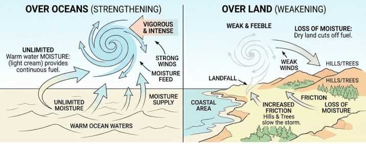
3. Behaviour over Oceans and Land
Over Oceans
- Cyclones become more vigorous and intense over warm ocean waters due to unlimited presence of moisture, which feeds the cyclone.
- They usually move with greater velocity over oceans.
Over Land
- Cyclones weaken rapidly after making landfall.
- Over land, they become weak and feeble due to the loss of moisture and increased surface friction.
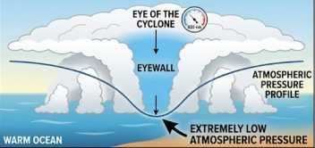
4. Centre of Cyclone
- The centre of a tropical cyclone is characterized by extremely low atmospheric pressure.
- This low pressure is mainly responsible for the high wind speeds around the cyclone.
5. Cyclonic Wind Movement
- The direction of cyclonic circulation differs in the two hemispheres:
- Northern Hemisphere: Winds move in an anticlockwise direction
- Southern Hemisphere: Winds move in a clockwise direction
6. Movement of Tropical Cyclones
- Tropical cyclones are not always mobile.
- Sometimes they remain stationary over a particular area for several days, causing heavy and continuous rainfall.
7. General Direction of Movement
- The usual movement of tropical cyclones is from east to west.
- This movement occurs under the influence of the Trade Winds.
8. Weakening of Cyclones
- Tropical cyclones weaken when they move into the subtropical regions.
- Cooler temperatures and reduced moisture supply reduce their intensity.
9. Frequency and Affected Area
- Tropical cyclones occur less frequently compared to temperate cyclones.
- Their area of influence is also relatively smaller than that of temperate cyclones.
Favorable conditions for Tropical Cyclone Formation
1. Warm Sea Surface Temperature (SST)
- A minimum Sea Surface Temperature (SST) of 26°–27°C is necessary for cyclone formation.
- Warm ocean water acts as the primary source of moisture that feeds the storm.
- The warm water layer should extend to a depth of nearly 60 m.
- Warm seas provide large amounts of latent heat energy, which strengthens the cyclone.
2. Coriolis Force
- The Coriolis Force is essential for bending winds and creating cyclonic circulation.
- Most tropical cyclones develop between 5° and 20° latitudes in both hemispheres.
Reason for this latitudinal limit
- At the Equator, the Coriolis Force is zero, so winds cannot bend to form cyclonic circulation.
- Between 0° and 4° latitude, the Coriolis force is too weak to organize rotating storms.
- Around 5° latitude, the Coriolis force becomes strong enough to support cyclone development.
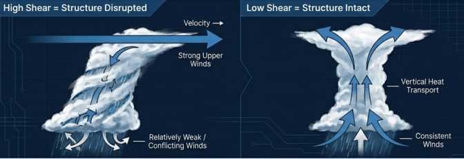
3. Low Vertical Wind Shear
- Vertical Wind Shear refers to changes in wind speed and direction with height.
- For cyclone formation, vertical wind shear must remain low.
- Strong wind shear disrupts the vertical structure of the cyclone and weakens its development.
4. Pre-existing Disturbance
- The presence of small low-pressure disturbances is necessary for cyclone development.
- Multiple low-pressure centres may merge together to form a large and organized low-pressure system.
- Such systems provide favourable conditions for the growth of a Tropical Cyclone.
5. Upper Troposphere Divergence
- Strong divergence in the upper troposphere is essential to maintain the cyclone’s structure.
Mechanism involved
- At the top of the cyclone, air is removed outward through divergence.
- At the surface, air rushes inward toward the low-pressure centre.
- This continuous circulation helps sustain and intensify the cyclone.
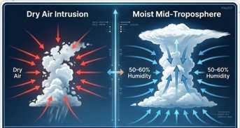
6. High Humidity Factor
- High humidity of about 50%–60% in the mid-troposphere is necessary for cyclone development.
- Moist air supports the formation of cumulonimbus clouds, which are crucial for cyclone growth.
Effect of Dry Air
- If the surrounding mid-level air is dry, cyclone formation becomes difficult.
- Dry air absorbs moisture from cloud droplets.
- This weakens cloud formation and reduces the energy available for cyclone intensification.
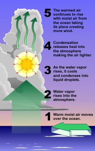
Origin and Development of Tropical Cyclone
- Tropical cyclones are mainly of thermal origin.
- They generally develop over tropical seas during late summer.
- Oceans retain heat for a longer duration because water has a high specific heat capacity.
- Strong local convectional currents develop over warm tropical oceans.
- Due to the influence of the Coriolis Force, these convection currents acquire a whirling motion.
- The cyclone continues to advance until it finds a weak area (land) in the wind belt and may eventually move toward continental regions.
- Stages involved in cyclone formation :
- Origin Stage
- Early Stage
- Mature Stage
1. Origin Stage
- Tropical cyclones originate under all the favourable conditions necessary for cyclone formation.
- An intense low-pressure system develops over warm tropical oceans.
- The air over the ocean becomes:
- Warm
- Light in density
- This warm and moist air begins to rise rapidly, initiating cyclonic circulation.
2. Early Stage
- Due to the excessive moisture available over oceans, the cyclone begins to intensify further.
- Air is sucked inward toward the low-pressure centre at a very high rate.
- Surrounding air rushes toward the centre and undergoes deflection due to the Coriolis Force.
- This creates a rotating vortex or spiralling column of air.
Formation of the Vortex
- The vortex develops because of centripetal acceleration toward the centre of the cyclone.
- In the upper atmosphere, air divergence occurs because of centrifugal acceleration away from the centre.
Formation of the Eye
- Air within the vortex is forced outward, creating a calm central region known as the Eye of the cyclone.
- The inner boundary surrounding the eye forms the Eyewall, which is the most violent and destructive part of the cyclone.
Vertical Air Movement
- Strong winds rise upward along the eyewall.
- As the air rises:
- It loses moisture through condensation
- Becomes colder and denser
- The cold and dense air then descends along the outer edges of the cyclone through a cylindrical region.
Intensification
- If the ocean continues supplying moisture and heat, the cyclone grows stronger and enters the mature stage.
3. Mature Stage
- During the mature stage, spiralling winds create several convective cells within the cyclone.
- These cells produce alternating regions of:
- Calm weather
- Violent storm activity
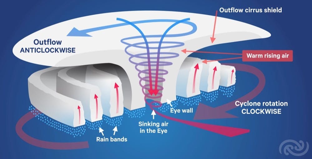
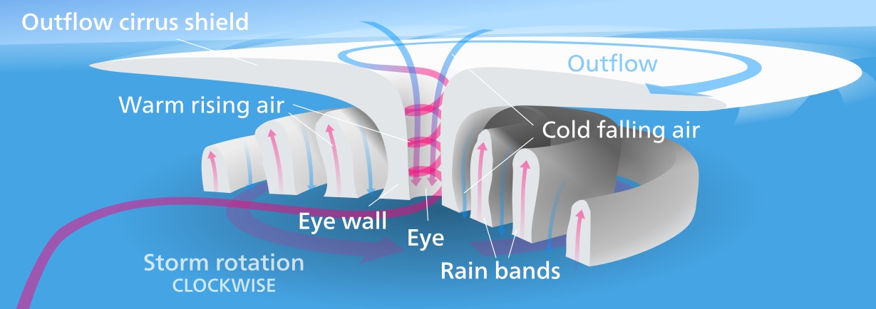
Rain Bands
- Regions containing dense cumulonimbus clouds are called Rain Bands.
- These rain bands produce:
- Intense rainfall
- Strong thunderstorms
Cloud Distribution
- Cloud size generally decreases from the centre toward the periphery of the cyclone.
Characteristics of Rain Bands
- Rain bands mainly consist of cumulonimbus clouds.
- They are responsible for the heavy rainfall and severe weather associated with tropical cyclones.
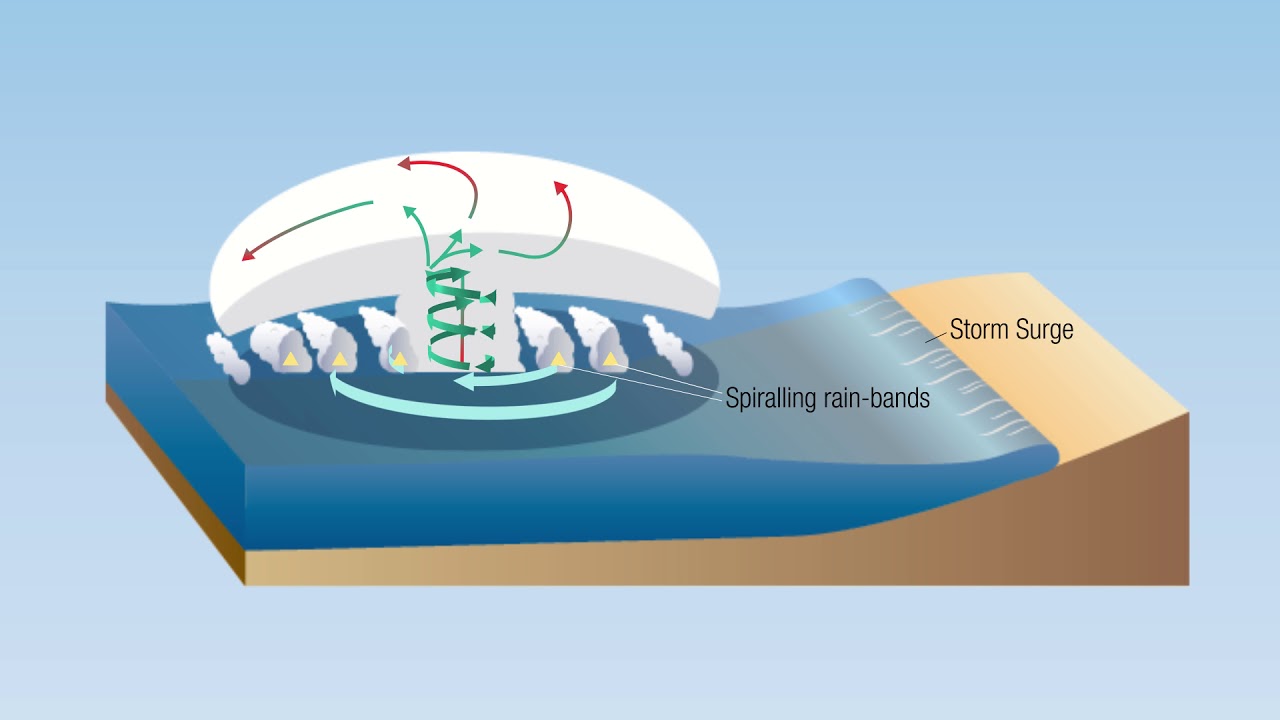
Structure of a Tropical Cyclone
Eye of Cyclone
- A mature tropical cyclone is characterized by strong spiralling winds surrounding a calm central region known as the Eye.
- The eye is a roughly circular area with:
- Light winds
- Clear skies
- Comparatively fair weather
- There is little or no precipitation inside the eye.
- Sometimes the blue sky or even stars may be visible through the eye.
- The eye represents the region of:
- Lowest surface pressure
- Warmest upper-level temperatures within the cyclone
- At an altitude of about 12 km, the eye may be nearly 10°C warmer than the surrounding atmosphere.
- Near the surface, the eye is usually only 0–2°C warmer than nearby regions.
- The size of the eye generally ranges between 8 km and 200 km, though most eyes are about 30–60 km in diameter.
Eye Wall
- The eye is surrounded by a circular zone of deep convection called the Eyewall.
- The eyewall is the region of:
- Highest wind speeds
- Most violent weather conditions
- The strongest sustained winds in a cyclone occur along the eyewall region.
- While the eye contains slowly sinking air, the eyewall experiences strong upward air movement due to intense convection.
Temperature characteristics of the Eye
- The warm temperatures inside the eye result from compressional (adiabatic) warming of descending air.
- Atmospheric soundings indicate:
- A relatively moist lower layer inside the eye
- A temperature inversion above it
- This suggests that descending air generally does not reach the ocean surface directly, but subsides to about 1–3 km above the surface.
Weather conditions in the Eyewall
- Wind speeds reach their maximum intensity in the eyewall.
- The region experiences torrential rainfall and severe thunderstorms.
- From the eyewall, rain bands extend outward.
- Trains of cumulus and cumulonimbus clouds spread toward the outer regions of the cyclone.
Spiral Bands
- Tropical cyclones contain long and narrow bands of convection known as Spiral Bands.
- These bands are aligned in the same direction as the horizontal wind flow.
- Since they appear to spiral inward toward the cyclone’s centre, they are called spiral bands.
Air circulation within Spiral Bands
- Low-level convergence is strongest within these bands.
- Above the bands, strong upper-level divergence takes place.
- A direct circulation develops in which:
- Warm, moist air converges at the surface
- Air rises through the spiral bands
- Diverges at higher altitudes
- Descends on both sides of the bands
Subsidence and Adiabatic Warming
- Descending air (subsidence) is spread over a large outer area but becomes concentrated on the inner side of the rain bands.
- As air descends, it undergoes adiabatic warming and becomes drier.
- Stronger inward warming creates a sharp pressure contrast across the bands.
- Since warm air is lighter, pressure falls toward the centre.
- This intensifies the pressure gradient, causing stronger tangential winds around the cyclone.
- Eventually, the spiral bands move inward and encircle the centre, leading to the formation of the Eye and Eyewall.
Formation of the Cloud-Free Eye
- The clear eye is formed due to:
- Dynamically forced outward movement of air from the eye toward the eyewall
- Forced descent of air caused by intense convection in the eyewall
Vertical Structure of a Tropical Cyclone
- The vertical structure of a tropical cyclone is divided into three layers.
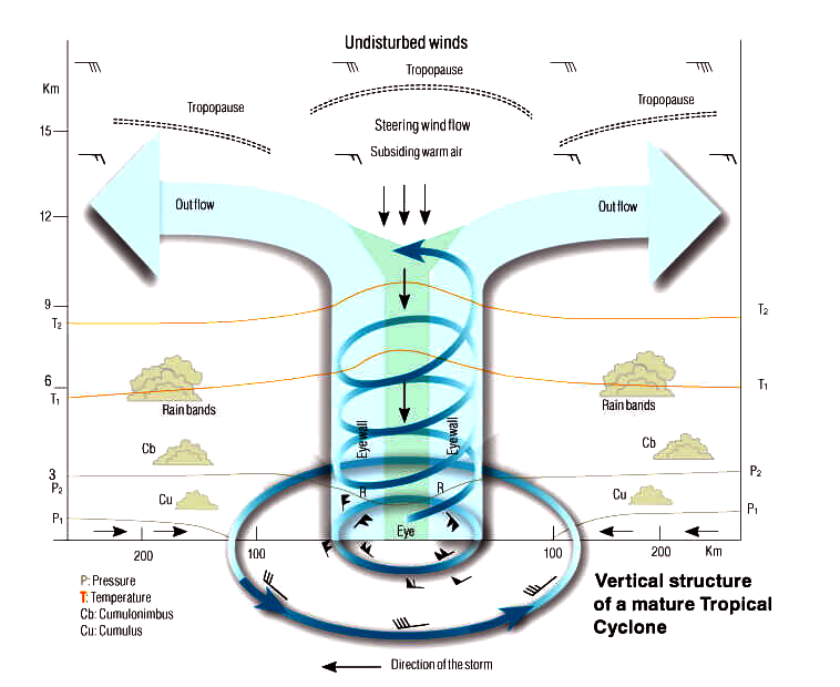
1. Inflow Layer
- Extends from the surface up to about 3 km.
- This layer drives the cyclone by drawing warm, moist air inward toward the centre.
2. Middle Layer
- Extends between 3 km and 7 km.
- This region contains the main cyclonic storm activity and intense convection.
3. Outflow Layer
- Lies above 7 km altitude.
- Maximum outflow occurs at around 12 km and above.
- Air movement in this layer is generally anticyclonic in nature.
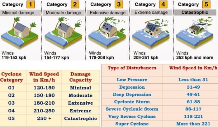
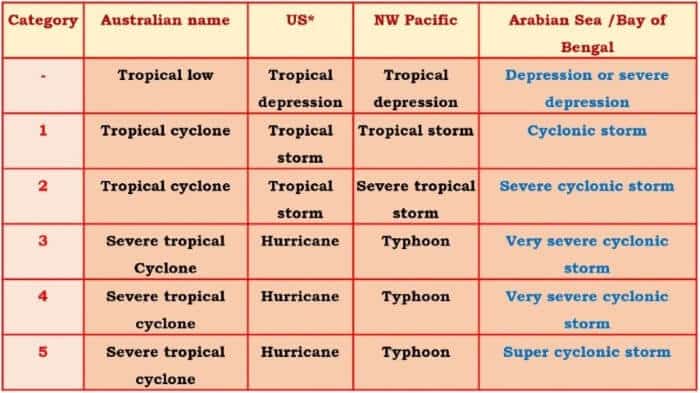
Categories of Tropical Cyclones
Category One (Tropical Cyclone)
- Strongest winds are classified as gales.
- Typical wind gusts range between 90–125 km/hr over open flat land.
Category Two (Tropical Cyclone)
- Associated with destructive winds.
- Typical gusts range between 125–164 km/hr.
Category Three (Severe Tropical Cyclone)
- Produces very destructive winds.
- Typical gusts range between 165–224 km/hr.
Category Four (Severe Tropical Cyclone)
- Characterized by extremely destructive winds.
- Typical gusts range between 225–279 km/hr.
Category Five (Severe Tropical Cyclone)
- The most intense category of tropical cyclones.
- Produces very destructive winds with gusts exceeding 280 km/hr.
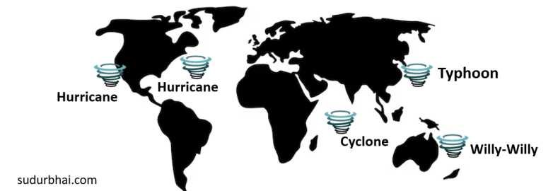
Favorite Breeding Grounds for Tropical Cyclones
- South-East Caribbean Region
- Cyclones in this region are called Hurricanes.
- Philippines, Eastern China, and Japan
- Tropical cyclones here are known as Typhoons.
- Bay of Bengal and Arabian Sea
- These storms are commonly called Cyclones.
- South-East African Coast and Madagascar–Mauritius Region
- Frequent development of tropical cyclones occurs here.
- North-West Australia
- Another major breeding ground for tropical cyclones.
Regional Names of Cyclones
Region | Name |
Atlantic & Eastern Pacific | Hurricane |
Western Pacific | Typhoon |
Indian Ocean | Cyclone |
Australia | Willy-Willy |
Tornado
- A Tornado is a violently rotating column of air that extends from a thunderstorm to the ground.
- It is essentially a rapidly rotating vortex of air.
- Tornadoes form when changes in wind speed and wind direction create a horizontal spinning motion within a storm cell.
- This spinning air is tilted vertically by strong rising air currents moving upward through thunderclouds.
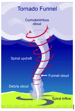
Features of Tornadoes
- Winds inside a tornado funnel may exceed 500 km/hr.
- The extremely high wind velocity causes most of the destruction associated with tornadoes.
- Tornadoes also damage structures through sudden air pressure reduction.
- The air pressure at the centre of a tornado may fall to nearly 800 millibars, compared to the normal sea-level pressure of 1013 millibars.
- Due to this intense pressure drop, many buildings and structures collapse outward.
Origin of Tornado
- Tornado formation generally requires four essential ingredients:
- Wind Shear
- Lift
- Atmospheric Instability
- Moisture
Role of Wind Shear
- Wind shear is the most important factor in tornado formation.
- Wind shear refers to changes in wind speed and direction with height.
- Under strong wind shear conditions, winds begin to roll into a horizontal column of rotating air.
Formation of Vertical Rotation
- Strong upward-moving air currents (updrafts) lift the rotating horizontal air column into a vertical position.
- Once the rotating air becomes vertical, storm development begins rapidly.
Formation of Supercell Thunderstorm
- In many cases, the storm develops into a Supercell Thunderstorm.
- Supercells are isolated storm cells that are separate from ordinary storm lines.
- These thunderstorms are characterized by strong rotation and spinning motion.
- The interaction of the rotating vertical air column and the supercell thunderstorm may produce a tornado extending from the cloud toward the ground.
Seasonal Occurrence of Tornadoes
- Tornadoes are most common during the spring season.
- They are least common during winter.
- Spring and autumn experience higher tornado activity because these seasons provide:
- Stronger winds
- Greater wind shear
- Increased atmospheric instability
- Tornado formation is also strongly influenced by the time of day because of solar heating.
Distribution of Tornadoes
- Tornadoes are rare in polar regions.
- They occur infrequently beyond 50° North and 50° South latitudes.
- Temperate and tropical regions are most favourable for thunderstorms and tornado formation.
- Tornadoes have been recorded on all continents except Antarctica.
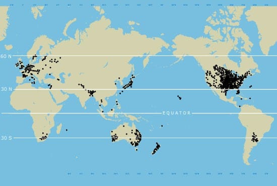
Countries prone to Tornadoes
- The United States experiences the highest number of violent tornadoes in the world.
- Canada records the second-largest number of tornadoes.
- In the Indian subcontinent, Bangladesh is the most tornado-prone country.
Global Thunderstorm Activity
- At any given moment, nearly 1,800 thunderstorms are occurring worldwide.
- Many of these thunderstorms have the potential to develop severe weather phenomena, including tornadoes.
Differences between Tornado and Cyclone
| Basis | Tornado | Cyclone |
|---|---|---|
| Definition | A Tornado is a rapidly rotating column of air that extends from a thunderstorm to the ground. It is usually associated with a funnel-shaped cumulonimbus cloud and has extremely destructive wind speeds ranging from 40–300+ mph. | A Cyclone is a large atmospheric system with rapidly circulating air around a low-pressure centre, generally accompanied by stormy and destructive weather conditions. Storms developing in the Southern Pacific are commonly called cyclones. |
| Rotation | Rotates clockwise in the Southern Hemisphere and anticlockwise in the Northern Hemisphere. | Rotates clockwise in the Southern Hemisphere and anticlockwise in the Northern Hemisphere. |
| Forms of Precipitation | Mainly associated with rain. | Associated with rain, sleet, and hail. |
| Frequency | The United States records nearly 1200 tornadoes annually. The Netherlands experiences the highest number of tornadoes relative to area. Tornadoes are more common during spring and autumn and less frequent in winter. | Around 10–14 cyclones develop annually on average. |
| Location | Tornadoes have been observed on all continents except Antarctica. | Commonly occur over the Southern Pacific Ocean and the Indian Ocean. In the Northwest Pacific, strong cyclones are called Typhoons when wind speeds exceed 74 mph. |
| Occurrence Conditions | Mostly develop in areas where cold and warm air masses converge. They can occur almost anywhere under suitable atmospheric conditions. | Generally form over warm tropical oceans and seas. |
Tornadoes and Cyclones in India
- Both Tornadoes and Cyclones occur in India.
- However, tornado outbreaks are much less frequent compared to cyclones.
Cyclones in India
- Cyclones mainly originate in:
- Bay of Bengal
- Arabian Sea
Two cyclone seasons:
1.Pre-monsoon: April–June
2.Post-monsoon: October–December (more severe)

Tornadoes in India
- Tornadoes in India are generally of weak intensity.
- They mostly occur in the:
- North-Western region
- North-Eastern region
- Even weak tornadoes can cause significant damage to:
- Human life
- Property
- Infrastructure