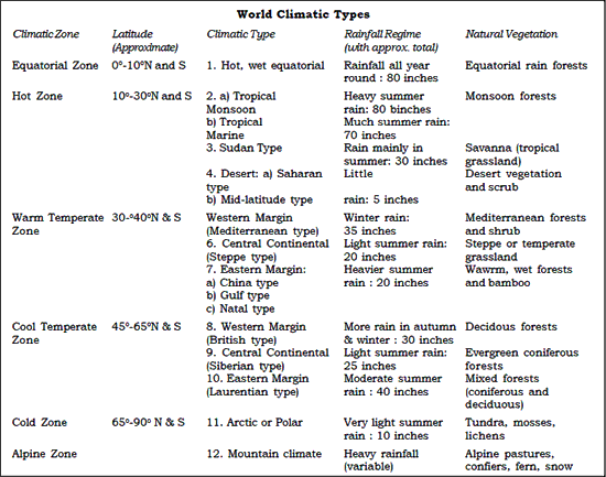
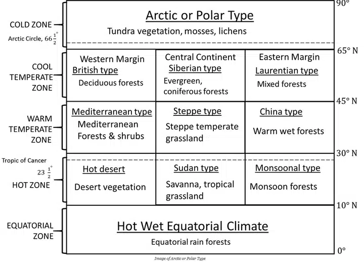
Climatic Regions of World

Weather

  • Weather refers to the state of the atmosphere at a particular place over a short period of time.
  • It includes atmospheric conditions such as:
    • Temperature
    • Humidity
    • Precipitation (type and amount)
    • Air Pressure
    • Wind
    • Cloud Cover
  • Weather differs from Climate because climate represents the average pattern of weather conditions over a long period, generally about 30 years.

Weather and the Troposphere

  • Weather phenomena mainly occur in the Troposphere, the lowest layer of the atmosphere.
  • The troposphere extends:
    • About 6–8 km above the poles
    • About 17 km above the Equator
  • Most weather activities are confined to the troposphere because:
    • Almost all clouds form here
    • Nearly all precipitation develops in this layer

Factors affecting Weather

  • Atmospheric phenomena occurring in the upper troposphere and above, such as:
    • Jet Streams
    • Upper-air waves
      significantly influence surface weather conditions.
  • These upper atmospheric processes affect:
    • High-pressure systems
    • Low-pressure systems
      thereby controlling weather at the Earth’s surface.
  • Geographic features also play an important role in influencing weather, especially:
    • Mountains
    • Large water bodies such as lakes and oceans

Ocean–Atmosphere Interaction

  • Recent studies show that anomalies in ocean surface temperatures can influence atmospheric temperatures over distant regions and future seasons.
  • One major example of ocean-atmosphere interaction is the:
    • El Niño–Southern Oscillation (ENSO)

Climate

  • Climate refers to the average atmospheric conditions of a place over a long period of time.
  • It is the long-term summary of weather conditions and their variations.
  • Climate is generally studied over a period of 30 years or more.

Elements of Climate

  • Climate is determined by long-term variations in the following atmospheric elements:
    • Solar Radiation
    • Temperature
    • Humidity
    • Precipitation (type, frequency, and amount)
    • Atmospheric Pressure
    • Wind (speed and direction)

climatic regions of world

World Climatic Types

Climatic Regions of World

climate types in world

Hot, Wet Equatorial Climate

Distribution

  • Found between 5° North and 10° South of the Equator.
  • Has minimal influence of trade winds; beyond this zone, climate gradually shifts to monsoon type.
  • Generally a hot and wet climate, though cooler pockets exist in high-altitude regions like Cameron Highlands (Malaysia).

Countries in this region include

  • Ecuador
  • Colombia
  • Brazil
  • Peru
  • Nigeria
  • Liberia
  • Myanmar
  • Thailand
  • Cambodia
  • Malaysia
  • Java (Indonesia)

Climate Characteristics

  • Temperature remains almost uniform throughout the year.
  • Average monthly temperature ranges between 24°C and 27°C.
  • There is no winter season.
  • Both diurnal and annual temperature ranges are very small.
  • Rainfall is very heavy (60–100 inches) and evenly distributed throughout the year.
  • A unique feature is the presence of double rainfall peaks coinciding with equinoxes.

Natural Vegetation

  • Supports dense tropical rainforests with luxuriant vegetation.
  • The Amazon rainforest is known as the Selvas.
  • Dominated by evergreen trees such as:
    • Mahogany
    • Ebony
    • Greenheart
    • Cabinet wood trees
  • Presence of lianas, epiphytes, and parasitic plants.
  • Pure stands of a single tree species are rare.

Economy

  • These regions are generally sparsely populated.
  • Indigenous people often practice hunting, gathering, and shifting cultivation.
  • Plantation agriculture is also present, including crops like:
    • Natural rubber
    • Cocoa
  • Overall economic development is limited due to dense forests and difficult terrain.

Hot, Wet Equatorial Climate

Savanna or Sudan Climate (Tropical Wet and Dry Climate)
  • The Savanna Climate is a transitional climate between:
    • Equatorial rainforests
    • Hot desert climates of trade wind regions
  • It lies entirely within the tropical belt (between Tropic of Cancer and Tropic of Capricorn).
  • Well developed in Sudan, hence the name Sudan Climate.

Distribution

  • Found mainly in tropical latitudes on both sides of the Equator.
  • Best developed in Sudan (Africa) with distinct wet and dry seasons.
Northern Hemisphere
    • Found in:
      • East Africa
      • African Sudan
      • Llanos grasslands (Orinoco Basin, South America)
Southern Hemisphere
    • Found in:
      • Campos grasslands (Brazilian Highlands)
      • Northern Australia (south of monsoon belt)

Temperature

  • Monthly temperature ranges between 20°C and 32°C in lowlands.
  • Annual average temperature is around 18°C.
  • Highest temperatures occur just before the rainy season:
    • April (Northern Hemisphere)
    • October (Southern Hemisphere)
  • During rainy season, cloud cover reduces temperature.
  • Noon temperatures may exceed 37°C in hot season.
  • Night temperatures may fall below 10°C, even causing frost in some areas.
  • A key feature is the high diurnal temperature range.

Precipitation

  • Climate is characterized by:
    • Hot, wet season
    • Cool, dry season
  • Rainfall occurs mainly in summer:
    • Northern Hemisphere: May–September
    • Southern Hemisphere: October–March
  • Rainfall decreases as distance from the Equator increases.

Winds

  • Dominated by Trade Winds (Easterlies).
  • These winds bring rainfall to coastal areas.
  • Maximum rainfall occurs on eastern coasts due to onshore winds.
Seasonal wind behavior
    • Summer: Onshore winds bring moisture and rainfall.
    • Winter: Offshore winds make conditions dry.
Harmattan Wind
    • In West Africa, dry northeasterly winds blow from the Sahara.
    • These winds are locally called Harmattan (“doctor wind”).
    • Effects:
      • Dry and dusty conditions
      • Damage to crops
      • Cooling effect by increasing evaporation

Vegetation

  • Dominated by tall grasses and scattered trees (parkland/bush-veld).
  • Tree density is highest near the Equator and rivers.
  • Trees are mostly deciduous, shedding leaves in dry season to reduce water loss.
  • Examples include Acacia.
  • Some trees store water in trunks (e.g., Baobab, Bottle tree).
  • Grass grows tall (6–12 feet), sometimes up to 15 feet (Elephant grass).
  • Grass becomes dormant in dry season and regrows in rainy season.
  • Vegetation gradually changes into thorn scrub near deserts.

Wildlife

  • Home to large terrestrial animals.
Herbivores
      • Zebra
      • Giraffe
      • Elephant
      • Antelope
Carnivores
      • Lion
      • Leopard
      • Hyena
      • Panther
      • Puma
      • Jaguar
Other animals
    • Along rivers:
      • Crocodiles
      • Hippos
      • Monitor lizards

Economy

  • Inhabited by nomadic pastoralists like the Masai (Kenya & Tanzania).
  • Also include settled tribes like the Hausa, practicing mixed farming and livestock rearing.
  • Plantation agriculture is important in regions like:
    • Northern Australia
    • Eastern Brazil
    • Central Africa
Major crops
    • Cotton
    • Sugarcane
    • Oil palm
    • Groundnuts
    • Coffee
    • Tropical fruits
    • Subsistence crops include millets, bananas, and vegetables.
Agricultural challenges
    • Frequent droughts affect productivity.
    • Heavy rainfall causes leaching of nutrients (nitrates, phosphates, potash).
    • Soils often become lateritic and infertile.
    • Poor-quality grass limits large-scale livestock farming.
    • However, some regions like Queensland (Australia) are major exporters of meat and dairy products.

Savanna Climate

Tropical Monsoon Climate

Distribution

  • Found between 5° to 30° latitudes on both sides of the Equator.
  • Strongly influenced by the Inter-Tropical Convergence Zone (ITCZ).
  • Regions remain hot and humid throughout the year due to high sun angle.
  • Monsoons are seasonal wind systems that reverse direction between land and sea.
  • Characterized by three distinct seasons: summer, winter, and rainy season.

Major Regions

  • Indian Subcontinent
  • Indo-China (Laos, Vietnam, Cambodia)
  • Thailand
  • Southern China
  • Northern Australia

Winds

  • Monsoon winds are caused by differential heating of land and sea.
  • In summer, a low-pressure system develops over Central Asia due to intense heating.
  • Surrounding oceans remain relatively high pressure.
  • In the Southern Hemisphere, high pressure develops over northern Australia during winter.
  • Winds move from high-pressure oceanic areas toward low-pressure land areas.
  • Due to the Coriolis force, winds are deflected and become South-West Monsoon winds.
  • In winter, wind direction is reversed.

Temperature

  • Region experiences high temperatures due to tropical location.
  • Average temperature remains above 18°C year-round.
  • Summer temperatures can reach up to 45°C in extreme cases.
  • Mean summer temperature is around 30°C.
  • Winter temperatures range between 15°C and 30°C, with an average of about 25°C.
  • Overall annual temperature range is 30–45°C.

Precipitation

  • Receives very high rainfall concentrated in a few months.
  • Average annual rainfall is about 200–250 cm, but can exceed 350 cm in some areas.
  • Mawsynram and Cherrapunji (Meghalaya, India) record over 1000 cm rainfall annually, making them the wettest places on Earth.
  • Heavy rainfall occurs due to orographic uplift and funneling effect in mountainous regions.

Seasons

Hot Dry Season (March to mid-June)
    • Sun shifts northwards toward the Tropic of Cancer.
    • Temperatures rise sharply across the region.
    • Central India may exceed 35°C–44°C in extreme areas.
    • Coastal regions remain cooler due to sea breeze influence.
    • Rainfall is minimal except occasional thunderstorms.
Rainy Season (mid-June to September)
    • Marked by burst of monsoon winds.
    • Accounts for over 70% of annual rainfall.
    • Characterized by heavy, continuous rainfall across the region.
Cold Dry Season (October to February)
    • Also called retreating monsoon season.
    • Winds reverse direction as high pressure develops over land.
    • Winds blow from land to sea, causing dry conditions.
    • Some rainfall occurs in southeast India due to northeast monsoon winds.
    • Western disturbances bring winter rain and snow to northern India.
Monsoon Forests
    • Also called Tropical Monsoon Forests.
    • Dominated by deciduous trees that shed leaves during dry season to reduce water loss.

Types of Forests

  • Moist deciduous forests: rainfall > 150 cm
  • Dry deciduous forests: rainfall < 150 cm
Characteristics
    • Composed of broadleaf hardwood trees.
    • Less dense than equatorial forests.
    • Lower biodiversity compared to rainforests.
Evergreen Forests
    • Found where rainfall exceeds 200–250 cm.
    • Present in:
      • Western Ghats (South India)
      • Northeast India
      • Andaman & Nicobar Islands
      • Parts of Southeast Asia
Transition Zones
    • Low rainfall areas support savanna-type vegetation.
    • Vegetation ranges from dense forests to thorny scrublands.

Economy

  • Region is highly populated.
  • Agriculture is the main occupation:
    • Subsistence farming
    • Shifting cultivation
    • Plantation agriculture
Major Crops
    • Plains: Rice, wheat, maize, sugarcane, jute, spices
    • Highlands: Tea, coffee, rubber, banana
Forestry and Timber
    • Important hardwood trees include:
      • Teak (central India, Myanmar)
      • Sal, Acacia, Eucalyptus, Neem, Mango
      • Bamboo
    • Lumbering is an important economic activity due to valuable timber resources.

Tropical Monsoon Climate

Desert Climate
  • Deserts are regions with very low rainfall and sparse vegetation.
  • The growing season is short due to limited moisture availability.
  • Characterized by low population density and harsh environmental conditions.

Types of Deserts

  • Hot Deserts (e.g., Sahara Desert)
  • Mid-Latitude Deserts (e.g., Gobi Desert)

Hot Deserts

     Distribution
    • Located between 15°–30° latitude on western continental margins.
    • Major deserts include:
      • Sahara Desert (largest)
      • Arabian Desert
      • Kalahari Desert
      • Thar Desert
      • Great Australian Desert
    • In the Americas:
      • Sonoran, Mojave, Californian, Mexican deserts (North America)
      • Atacama Desert (South America)
     Temperature
    • Among the hottest regions on Earth.
    • Summer temperatures exceed 30°C regularly.
    • Record temperature: 57°C (Libya, 1922).
    • High temperatures due to:
      • Clear skies
      • Strong insolation
      • Dry air
      • Low humidity
     Temperature Variations
    • Coastal deserts are moderated by cold ocean currents.
    • Interior deserts experience extreme heat in day and cold nights.
    • Diurnal range: 14°C–25°C.
    • Frost may occur during winter nights.
     Precipitation
    • Annual rainfall is generally below 25 cm.
    • Located in subtropical high-pressure zones (horse latitudes).
    • Descending air prevents cloud formation.
    • Trade winds are offshore, reducing moisture supply.
    • Cold ocean currents reduce evaporation and rainfall.
    • Some rainfall occurs as short, intense convectional storms.
    • Atacama Desert is the driest region (<2 cm rainfall annually).

Mid-Latitude Deserts

     Distribution
    • Found in continental interiors and plateaus.
    • Examples include:
      • Gobi Desert
      • Turkestan Desert
      • Patagonian Desert
      • Ladakh Desert (India)
     Climate
    • Similar to hot deserts in dryness but more extreme in temperature variation.
    • Located far from oceans or blocked by mountains.
    • Annual rainfall remains below 25 cm.
    • Experience occasional winter rainfall due to depressions.
    • Strong continentality effect leads to:
      • Very cold winters
      • Hot summers
    • Melting snow in summer may cause flooding in some regions.

Desert Vegetation

  • Vegetation is xerophytic (drought-resistant).
  • Includes:
    • Cacti
    • Thorny bushes
    • Wiry grasses
    • Dwarf acacia
  • Some areas support date palm clusters (near groundwater).
     Adaptations
    • Deep root systems to access groundwater.
    • Leaves reduced to minimize transpiration.
    • Waxy or hairy surfaces to conserve moisture.
    • Seeds remain dormant until rainfall occurs.
    • Soils are poor in humus due to slow decomposition.

Life in Deserts (Types of Human Settlements)

     1. Primitive Groups
    • Hunters and gatherers
    • Examples: Bushmen (Kalahari), Aborigines (Australia)
     2. Nomadic Herdsmen
    • Livestock-based economy.
    • Examples: Bedouins (Arabia), Tuaregs (Sahara), Mongols (Gobi)
     3. Settled Agriculture
    • Practised near rivers:
      • Nile (Egypt)
      • Indus (Pakistan)
      • Colorado (USA)
      • Tigris-Euphrates (Iraq)
    • Crops: wheat, barley, sugarcane, fruits, vegetables
     4. Mining Settlements
    • Resource-based economies:
      • Gold (Australia)
      • Diamonds (Kalahari)
      • Copper (Chile)
      • Silver (Mexico)
      • Oil (Persian Gulf)

Desert Climate

Steppe Climate

  • The term steppe refers to a semi-desert grassland region with sparse grass and shrub vegetation.
  • It represents an intermediate climate zone—not dry enough to be a desert and not wet enough to support forests.
  • Also known as Temperate Grasslands.
  • Often called “grain baskets” due to large-scale agricultural production.
  • Livestock ranching is a major economic activity due to abundant natural grasses.

Distribution

  • Found in continental interiors.
  • Located mainly in the temperate latitudes under the influence of Westerly winds.
  • Characterized by vast treeless grasslands.

Major Steppe Regions (Global Names)

  • Eurasian Steppe (largest continuous belt; Black Sea to Altai Mountains)
  • Prairies – North America
  • Pustaz – Hungary
  • Pampas – Argentina & Uruguay
  • Velds (High Veld) – South Africa
  • Downs – Australia
  • Canterbury Grasslands – New Zealand

Major world grasslands - Prairies , Velds , Pustaz , Pampas , Downs and Canterbury | sudurbhai.com

Precipitation

  • Annual rainfall ranges between 25 cm and 75 cm.
  • Maximum rainfall occurs in spring / early summer.
  • In Northern Hemisphere, rainfall peaks around June–July.
  • Winters may receive occasional snowfall due to Westerly depressions.
  • Southern Hemisphere steppes receive slightly higher rainfall due to maritime influence.

Temperature

  • Climate is influenced by continentality, leading to temperature extremes.
  • Summers: Warm, around 18°C–20°C.
  • Winters: Cold, often with snowfall.
  • Northern Hemisphere steppes show high annual temperature range.
  • Southern Hemisphere steppes have a more moderate climate due to ocean influence.

Winds

  • Dominated by Westerlies, which bring winter precipitation.
  • Influenced by several local winds, such as:
    • Mistral (France) – cold, dry wind
    • Loo (India) – hot, dry summer wind
    • Sirocco (Sahara/Mediterranean) – hot, dusty wind
    • Foehn (Alps) – warm, dry wind
    • Chinook (North America) – warm, dry katabatic wind

Chinook Wind

  • Descends from the Rocky Mountains.
  • Raises temperature rapidly by 5°C or more within minutes.
  • Helps agriculture by melting snow on pastures.

Vegetation

  • Dominated by short, treeless grasslands.
  • Grass is shorter than savanna grass, but more nutritious and soft.
  • Example: Chernozem soils of Ukraine and North American prairies.
  • Supports large-scale livestock ranching.
  • Grass grows throughout the year with minimal seasonal interruption.
  • Northern edges may show transition to coniferous forests.
  • Trees may be planted as windbreaks in agricultural zones.

Economy

  • Limited animal diversity compared to savannas.
  • Open landscapes support horse grazing in Eurasian steppes.

Agriculture

  • Highly developed mechanized farming.
  • Known as the “Granaries of the World” (especially Prairies).
  • Major crops:
    • Wheat
    • Maize

Major Agricultural Regions

  • Prairies (North America) – wheat, livestock ranching
  • Pampas (Argentina) – wheat, dairy, beef export
  • Velds (South Africa) – maize, sheep & cattle rearing
  • Pustaz (Hungary) – wheat, sugar beet cultivation
  • Downs & Canterbury (Australia & New Zealand) – wool and dairy production

Livestock Ranching

  • Large-scale animal husbandry practiced over vast areas.
  • Replacement of natural grass with alfalfa (lucerne) improves livestock quality.
  • Major products include:
    • Milk
    • Butter
    • Cheese
    • Beef
    • Animal skins

Nomadic Herding

  • Practised in Eurasian steppes by groups like Kazakhs and Kirghiz.
  • Movement driven by seasonal droughts and lack of reliable rainfall.

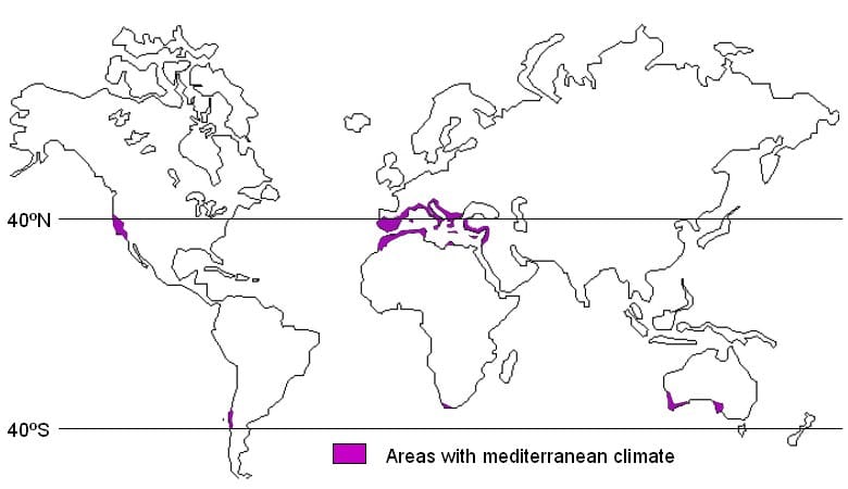
Mediterranean Climate (Western Margin Climate)

Distribution

  • Found between 30° and 45° latitudes in both hemispheres.
  • Occurs mainly along western continental margins.
  • Controlled by seasonal shift of wind belts.

Major Regions

  • Central Chile
  • California (USA)
  • Cape Town region (South Africa)
  • Southern Australia (Adelaide, Victoria region)
  • South-West Australia (Swanland)

Climate

     Summer (Dry & Warm)
    • Influenced by off-shore Trade Winds.
    • Subtropical high-pressure belt shifts poleward.
    • Results in dry, rainless summers.
    • High evaporation and low humidity.
    • Interior regions experience severe drought conditions.
     Winter (Wet & Cool)
    • Westerlies shift equatorward.
    • Winds become on-shore, bringing rainfall.
    • Receives most of its annual precipitation in winter.
    • Rainfall is often heavy and causes flooding (e.g., Mediterranean Europe).

Local Winds

     Sirocco
    • A hot, dry, dusty wind originating from the Sahara Desert.
    • Occurs mostly in spring.
    • Can last for a few days.
    • Causes crop damage and vegetation stress.
    • Known as “Blood Rain” due to red dust transport.
     Mistral
    • A cold, strong wind blowing from the north.
    • Travels through the Rhône Valley (France).
    • Intensified by the funnel effect between Alps and Central Massif.
    • Can disrupt transport and lower temperatures below freezing.
     Other Winds
    • Bora – cold north-easterly wind along Adriatic coast.
    • Tramontana & Gregale – cold winds in Mediterranean region.

Natural Vegetation

  • Vegetation is not dense or luxuriant.
  • Dominated by xerophytic (drought-resistant) plants.
  • Plants are adapted to heat, dryness, and long droughts.

Types of Vegetation

Evergreen Forests
    • Found in regions with rainfall above 25 inches.
    • Includes evergreen oaks and open woodlands.
    • Cork oak used for bottle cork production.
    • In Australia, replaced by eucalyptus forests.
    • In California, includes giant sequoia (redwoods).
Coniferous Forests
    • Found in cooler highlands.
    • Includes pine, fir, cedar, cypress.
Bushes and Shrubs
    • Most dominant vegetation type.
    • Thorny, scattered shrubs adapted to dryness.
Grass
    • Sparse and not suitable for intensive grazing.
    • Growth limited due to summer drought and winter rainfall pattern.

Economic Development

  • Region supports diversified agriculture and industries.
  • Major activities include:
    • Fruit cultivation
    • Cereal farming
    • Wine production
    • Mining and engineering industries
  • Major exporter of citrus fruits and importer of dairy products.

Orchard Farming

  • Known as “World’s Orchard Lands”.
  • Major fruits:
    • Oranges (California, Israel)
    • Olives (most characteristic crop)
    • Peaches, apricots, pears, cherries, figs
    • Nuts: almonds, walnuts, hazelnuts, chestnuts
  • Trees have deep root systems to survive dry summers.

Crop Cultivation

  • Major cereals: wheat and barley.
  • Farming adapted to seasonal rainfall patterns.

Sheep Rearing

  • Practised in mountain pastures.
  • Includes transhumance (seasonal migration of livestock).

Wine Production

  • Known for viticulture (grape cultivation).
  • Long sunny summers favor grape ripening.
  • Mediterranean region contributes nearly 75% of global wine production.

Mediterranean Climate

Warm Temperate Eastern Margin Climate

Location

  • Found along eastern margins of continents
  • Between 20° and 35° North and South latitude
  • Similar to monsoonal climate with:
    • Wet summers
    • Dry winters

Variations

     China Type
    • Found in most parts of China
    • Modified monsoonal climate
    • Strong seasonal wind reversal
    Gulf Type
    • Found in south-eastern USA near Gulf of Mexico
    • Similar to China type but weaker monsoon effect
    • Summer heating draws moist Atlantic air inland
     Natal Type
    • Found in:
      • New South Wales
      • Natal
      • Paraná–Paraguay–Uruguay basin
    • Maritime influence dominant
    • Rainfall fairly uniform throughout year

Climate Features

  • Warm, moist summers
  • Cool, dry winters
  • Occasional frost due to cold air intrusion
  • Moderate to heavy rainfall (60–150 cm)
  • Rainfall sources:
    • Convectional rain
    • Orographic rain
    • Cyclonic depressions
  • Frequent storms:
    • Typhoons
    • Hurricanes
  • Highly suitable for agriculture → dense population
China Type Details
    • Strong seasonal monsoon circulation
    • Summer:
      • Low pressure over Central Asia
      • South-East monsoon brings rain
    • Winter:
      • High pressure over Siberia
      • Cold, dry North-West winds
    • Typhoons common in late summer
Gulf Type Details
    • Weak monsoon influence
    • Warm Gulf Stream moderates climate
    • Rainfall ~59 inches annually
    • Rain sources:
      • Thunderstorms
      • Hurricanes (Sept–Oct)
    • Tornadoes common due to heating contrasts
Natal Type Details
    • Strong maritime influence
    • Trade winds bring steady moisture
    • Rain distributed throughout year
    • Low temperature range

Natural Vegetation

  • Dense and diverse vegetation
  • Evergreen and deciduous forests in lowlands
  • Coniferous forests in highlands
  • Examples:
    • Eucalyptus (Australia)
    • Paraná pine, quebracho (South America)
    • Palm trees (Natal region)

Economic Development

  • Highly productive middle latitude regions
  • Continuous growing season
  • Intensive agriculture dominates
  • High population density

Farming in Monsoon China

  • One of the most populated regions globally
  • Major rice-producing area (1/3 of world rice)
  • Conditions favour paddy cultivation:
    • Warm climate
    • Adequate rainfall
    • Fertile alluvial soil
  • Farming features:
    • Wet paddy cultivation
    • Labour-intensive
    • Subsistence farming dominant
    • Double and triple cropping increasing
  • Sericulture declining

Agriculture in Gulf States (USA)

Corn
    • Humid summers and rainfall suitable
    • Major global producer (>50%)
    • Used mainly for animal feed
Cotton
    • Major cash crop
    • Long frost-free season (~200 days)
    • Important for economy of southern USA
    • Pest: boll weevil affects production
Tobacco
    • Native crop of America
    • Grows in warm, humid, well-drained soils
    • Major share in global trade (~50%)
Southern Hemisphere Eastern Margins
Natal Region
    • Sugarcane dominant crop
    • Cotton and tobacco in interiors
    • Maize widely cultivated
    • Pastoral farming common (cattle and sheep)
South America
    • Lower rainfall
    • Focus on cattle and sheep rearing
    • Products: meat, wool, hides
Australia
    • Moist trade winds bring rainfall
    • Dense eucalyptus forests
    • Products:
      • Milk
      • Butter
      • Cheese
      • Cotton
      • Sugarcane
      • Maize

China Type Climate

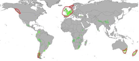
British Type Climate (Cool Temperate Western Margin)

Distribution

  • Britain, NW Europe, British Columbia
  • Southern Chile, Tasmania, New Zealand
  • Strong oceanic influence

Climate

  • Mild summers
  • Mild winters
  • Even rainfall distribution

Temperature

  • Annual range: 5°C–15°C
  • No extreme cold due to ocean currents

Precipitation

  • Rain throughout year
  • Western margins get highest rainfall
  • Slight winter maximum

Seasons

  • Summer: warm and long
  • Autumn: windy
  • Winter: cold, foggy, rainy
  • Spring: dry and pleasant

Natural Vegetation

  • Deciduous forests dominate
  • Trees shed leaves in winter
  • Common trees:
    • Oak
    • Elm
    • Ash
    • Birch
    • Beech
  • Conifers in high altitudes

Economic Development

Agriculture
    • High population density → food imports
    • Market gardening highly developed
    • Mixed farming common:
      • Crop farming + livestock rearing
    • Main crops:
      • Wheat (mostly domestic use)
      • Barley (beer, whisky)
    • Major activities:
      • Dairy farming
      • Sheep rearing (wool and meat)
Industry
    • Highly industrialised region
    • Industries:
      • Machinery
      • Chemicals
      • Textiles
    • Major industrial regions:
      • Ruhr (Germany)
      • Manchester, Yorkshire (UK)

British Type Climate

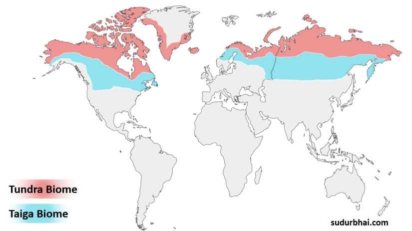
Taiga Climate (Boreal / Sub-Arctic / Siberian Climate)

Location

  • Found between 50°N to 70°N in a continuous belt
  • Occurs only in the Northern Hemisphere
  • Regions include:
    • Canada
    • Scandinavia
    • Siberia

Reason for absence in Southern Hemisphere:

  • Lack of large continental landmasses at these latitudes

Climate characteristics

  • Very long and severe winters (−30°C to −40°C)
  • Short and cool summers (just above 10°C)
  • Very high annual temperature range (50–60°C)

Key idea: Strong continentality leads to extreme temperature variation

Vegetation

  • Dominated by evergreen coniferous forests (Taiga)
  • Main species include pine, fir, spruce, and larch

Adaptations of conifers:

  • Cone-shaped structure prevents snow accumulation
  • Needle-like leaves reduce water loss
  • Flexible branches withstand strong winds
  • Can survive poor, acidic soils

Reason for sparse undergrowth:

  • Low temperatures slow decomposition
  • Lack of humus formation
  • Short growing season limits plant diversity

Economic activities

  • Region is sparsely populated and underdeveloped

Main activities:

  1. Lumbering (most important)
  2. Trapping (fur industry)
  3. Hunting and fishing

Lumbering advantages

  • Trees grow in pure stands
  • Uniform size and straight trunks increase commercial value
  • Winter logging is easier due to frozen ground
  • Rivers assist log transport, though limited in Siberia due to Arctic drainage

Taiga biome Tundra Biome | sudurbhai.com

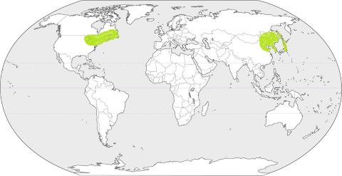
Laurentian Climate (Cool Temperate Eastern Margin Climate)

Location

Found in only two main regions:

  • North America (northeastern USA, eastern Canada)
  • East Asia (northern China, Korea, Japan, Manchuria)

Reason:

  • Eastern continental margins influenced by both maritime and continental factors

Climate characteristics

  • Cold and dry winters
  • Warm and wet summers

Key feature:

  • Monsoon-like rainfall distribution in temperate regions

Rainfall pattern

  • Summer: Moist winds from oceans bring heavy rainfall
  • Winter: Dry continental winds dominate

Special case in North America:

  • Gulf Stream increases moisture
  • Labrador Current contributes to fog and precipitation
  • High frequency of fog in Newfoundland region

Vegetation

  • Mixed forests:
    • Coniferous forests in northern areas
    • Deciduous forests in southern areas

Economic activities

1. Lumbering
  • Highly developed due to accessible forests
2. Agriculture
  • Dairy farming
  • Fruit cultivation
  • Mixed farming practices
3. Fishing
  • Important in coastal regions

Major fishing areas:

  • Grand Banks (Newfoundland)
  • Coastal Japan

Reason for rich fisheries:

  • Mixing of warm and cold ocean currents increases plankton availability

Comparison: Taiga vs Laurentian Climate

FeatureTaiga ClimateLaurentian Climate
LocationInterior high latitudesEastern continental margins
TemperatureExtremely cold and harshModerately cold winters, warm summers
RainfallLow and mostly snowModerate, with summer maximum
VegetationPure coniferous forestsMixed forests
EconomyPrimitive (logging, trapping)Diversified (agriculture, fishing, industry)
PopulationSparseRelatively dense

Laurentian Climate

Polar Climate (Tundra & Ice Caps)

General Features

  • Polar climate has cold conditions throughout the year
  • Köppen classification: E type climate
  • Summer temperature is below 10°C
  • Divided into:
    • Polar Tundra
    • Polar Ice Caps

Distribution

     Northern Hemisphere
    • Found north of the Arctic Circle
    • Ice caps:
      • Greenland
      • High latitude highlands (permanent snow cover)
    • Tundra areas (seasonal ice-free zones):
      • Coastal Greenland
      • Northern Canada (barren grounds)
      • Alaska
      • Arctic seaboard of Eurasia
     Southern Hemisphere
    • Antarctica is the largest ice-cap region
    • Permanently covered with thick ice sheets
    • Almost completely uninhabited

Climate

     Temperature
    • Very low mean annual temperature
    • Only about 4 months above 0°C
    • Ground remains frozen most of the year
    • Interiors are colder than coastal areas
    • Winters are long and severe
    • Summers are short and cool
    • Continuous darkness in winter beyond polar circles
    • Frequent frost and blizzards
     Precipitation
    • Mainly in the form of snow
    • Snowfall occurs in winter and is blown by blizzards
    • Very low evaporation → very little rainfall
    • Convectional rain is almost absent
    • Summer precipitation occurs as rain or sleet
    • Coastal areas may experience cyclonic rainfall
    • Slight tendency for winter precipitation maximum

Natural Vegetation

  • Very limited vegetation due to extreme cold
  • Growing season is less than 3 months
  • No trees in true tundra regions
  • Main vegetation types:
    • Mosses
    • Lichens
    • Sedges
  • In sheltered areas:
    • Dwarf birch
    • Willow
    • Alder
  • Summer vegetation:
    • Arctic flowers
    • Berry bushes
  • Short growing period creates “Arctic bloom”

Human Activities

General Pattern
  • Settlement mainly along coastal areas
  • Interior highlands and plateaus are uninhabitable
  • People lead semi-nomadic life
     Eskimos (Inuit)
    • Found in Greenland, northern Canada, Alaska
    • Traditional activities:
      • Hunting
      • Fishing
      • Food gathering
    • Modern changes:
      • Some permanent settlements
    • Housing:
      • Igloos in winter
      • Skin tents in summer
    • Food sources:
      • Fish
      • Seals
      • Walruses
      • Polar bears
     Eurasian Tundra Tribes
    • Lapps (Sami): Northern Finland and Scandinavia
    • Samoyeds: Siberia (Ural to Yenisey Basin)
    • Yakuts: Lena Basin
    • Koryaks and Chukchi: North-eastern Asia
    • Lifestyle:
      • Nomadic or semi-nomadic
      • Reindeer herding
      • Seasonal migration for grazing

Economic Importance & Development

  • Earlier considered economically useless
  • Now recognized for resource potential
  • Developments :
    • Discovery of minerals led to settlements
    • New railway lines built for transporting ores
    • Arctic ports developed along Eurasian coast
    • Export of:
      • Timber
      • Fur
      • Mineral resources from Siberia

Leave a Comment

Your email address will not be published. Required fields are marked *

Index
Scroll to Top