
Latitudes, Longitudes and International Date Line
The Geographical Grid is an imaginary network of Latitudes (Parallels) and Longitudes (Meridians) drawn on the Earth’s surface. It enables the accurate determination of the location, distance, direction, time, and climatic zones of any place on Earth.
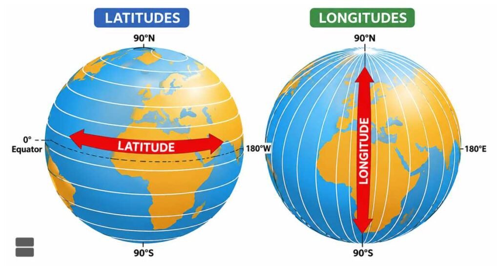
Latitudes
- Latitudes are imaginary parallel circles drawn around the Earth parallel to the Equator.
- They measure the angular distance of a place north or south of the Equator.
- Latitude is expressed in degrees (°), minutes (‘), and seconds (“).
- The Equator (0° Latitude) is the reference line from which all latitudes are measured.
Range of Latitudes
- 0° – Equator
- 90° North – North Pole
- 90° South – South Pole
Thus, latitudes extend from 0° to 90° in both hemispheres.
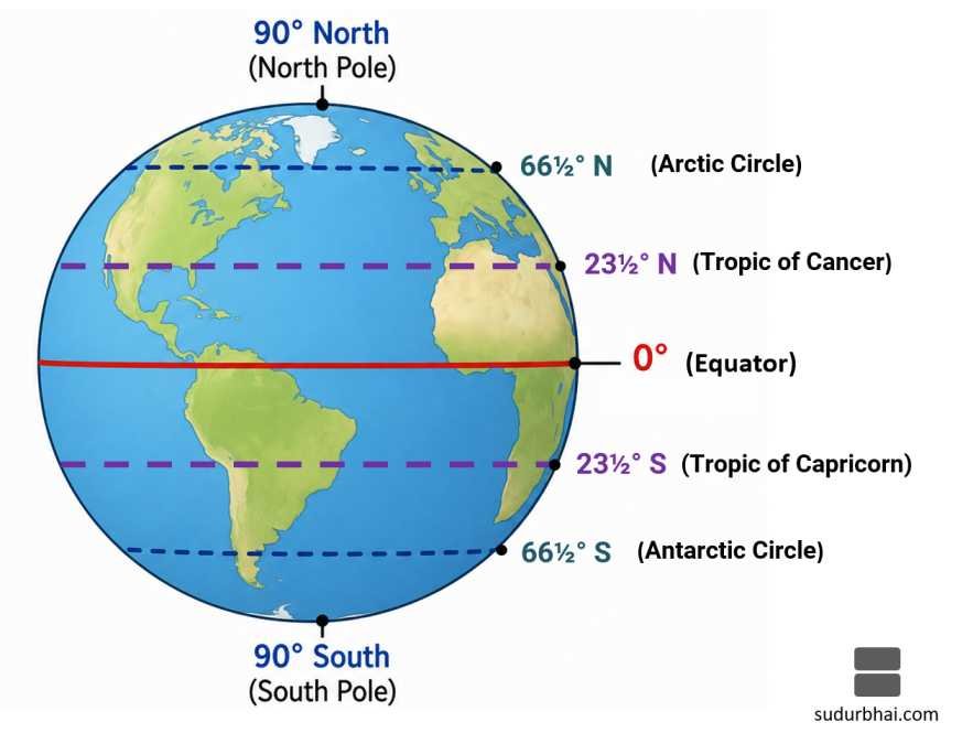
Characteristics of Latitudes
- Latitudes are parallel to one another.
- They never intersect each other.
- Their length decreases from the Equator towards the poles.
- The Equator is the longest latitude.
- The North Pole and South Pole are represented by points, not circles.
- All latitudes run in an East–West direction.
Important Parallels of Latitude
| Latitude | Name | Importance |
|---|---|---|
| 0° | Equator | Divides Earth into Northern and Southern Hemispheres |
| 23½° N | Tropic of Cancer | Northern limit of the overhead Sun |
| 23½° S | Tropic of Capricorn | Southern limit of the overhead Sun |
| 66½° N | Arctic Circle | Beginning of Polar Day and Polar Night in the Northern Hemisphere |
| 66½° S | Antarctic Circle | Beginning of Polar Day and Polar Night in the Southern Hemisphere |
| 90° N | North Pole | Northern end of Earth’s axis |
| 90° S | South Pole | Southern end of Earth’s axis |
Importance of Latitudes
Latitudes are useful for:
- Determining the north-south position of a place.
- Identifying climatic zones.
- Calculating solar altitude.
- Understanding length of day and night.
- Studying temperature distribution.
- Explaining vegetation and agricultural patterns.
- Preparing weather and climate maps.
Countries passing through important Parallels
- Through Equator
- Through Tropic of cancer
- Through Tropic of capricorn
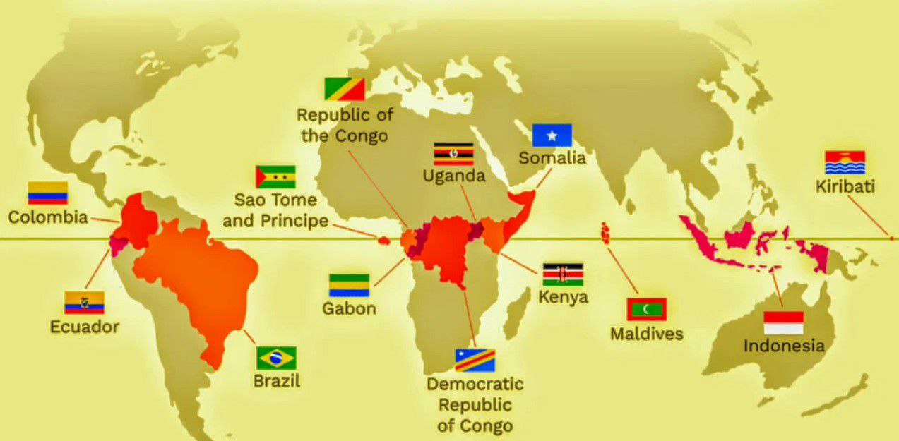
Through Equator
The equator passes through 13 countries, across three continents ;
- Ecuador
- Colombia
- Brazil
- São Tomé and Príncipe
- Gabon
- Republic of the Congo
- Democratic Republic of the Congo
- Uganda
- Kenya
- Somalia
- Maldives
- Indonesia
- Kiribati
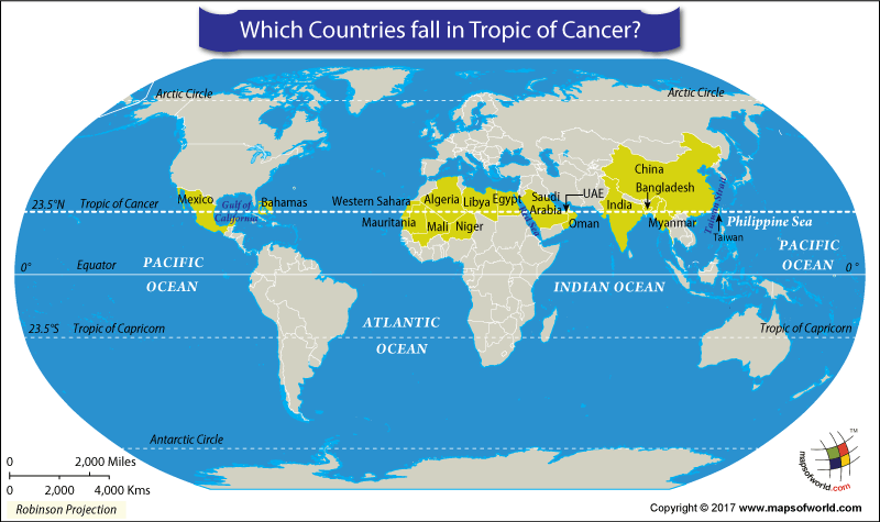
Through Tropic of cancer
The Tropic of Cancer passes through 17 countries across three continents :
- Bahamas
- Mexico
- Western Sahara
- Mauritania
- Mali
- Algeria
- Niger
- Libya
- Egypt
- Saudi Arabia
- United Arab Emirates
- Oman
- India (crosses Gujarat, Rajasthan, Madhya Pradesh, Chhattisgarh, Jharkhand, West Bengal, Tripura, and Mizoram)
- Bangladesh
- Myanmar
- China
- Taiwan
Through Tropic of capricorn
The Tropic of Capricorn passes through 10 countries across three continents:
- Brazil
- Paraguay
- Argentina
- Chile
- Namibia
- Botswana
- South Africa
- Mozambique
- Madagascar
- Australia

Heat Zones of the Earth
Based on latitude, the Earth is divided into three major Heat Zones.
- Torrid Zone (Tropical Zone)
Temperate Zones
- Polar Zone
Torrid Zone
- Lies between 23½° N and 23½° S.
- Receives vertical rays of the Sun.
- Experiences the highest temperatures.
- Also known as the Tropical Zone.
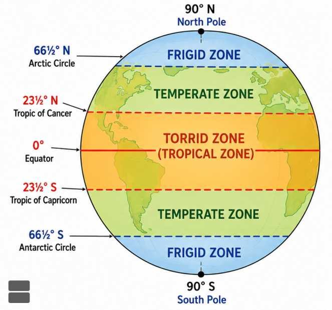
Temperate Zones
Northern Temperate Zone
- Between 23½° N and 66½° N
Southern Temperate Zone
- Between 23½° S and 66½° S
Characteristics
- Receives slanting rays of the Sun.
- Experiences moderate temperatures.
- Four distinct seasons occur.
Frigid Zones
Northern Frigid Zone
- Between 66½° N and 90° N
Southern Frigid Zone
- Between 66½° S and 90° S
Characteristics
- Receive highly oblique rays.
- Extremely cold climate.
- Experience Polar Day and Polar Night.
Longitudes
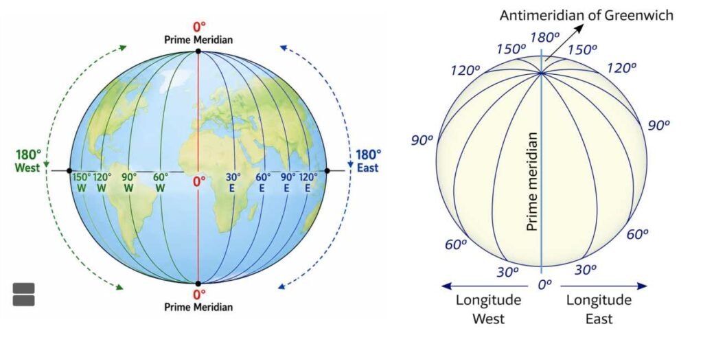
- Longitudes are imaginary semicircles joining the North Pole and the South Pole.
- They measure the angular distance east or west of the Prime Meridian.
- The Prime Meridian (0° Longitude) passing through Greenwich, London (United Kingdom) serves as the reference line.
Range of Longitudes
- 0° – Prime Meridian
- 180° East
- 180° West
Total number of longitudes = 360°
Characteristics of Longitudes
- Longitudes are equal in length.
- They meet at both poles.
- They are farthest apart at the Equator.
- The distance between longitudes decreases poleward.
- They run in the North–South direction.
Prime Meridian
- The Prime Meridian (0°) divides the Earth into:
- Eastern Hemisphere
- Western Hemisphere
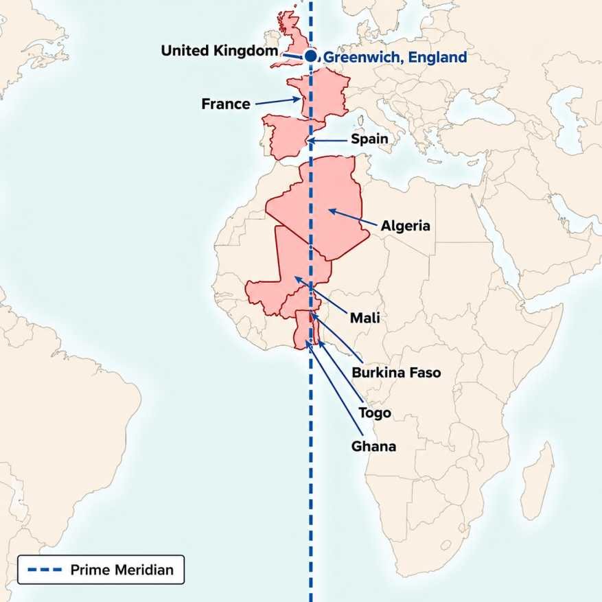
- The Prime Meridian (0° longitude) passes through eight countries in Europe and Africa: the United Kingdom, France, Spain, Algeria, Mali, Burkina Faso, Togo, and Ghana.
Importance
- Serves as the reference line for measuring longitude.
- Basis of Greenwich Mean Time (GMT) and Coordinated Universal Time (UTC).
- Used for global timekeeping and navigation.
Great Circle and Small Circle
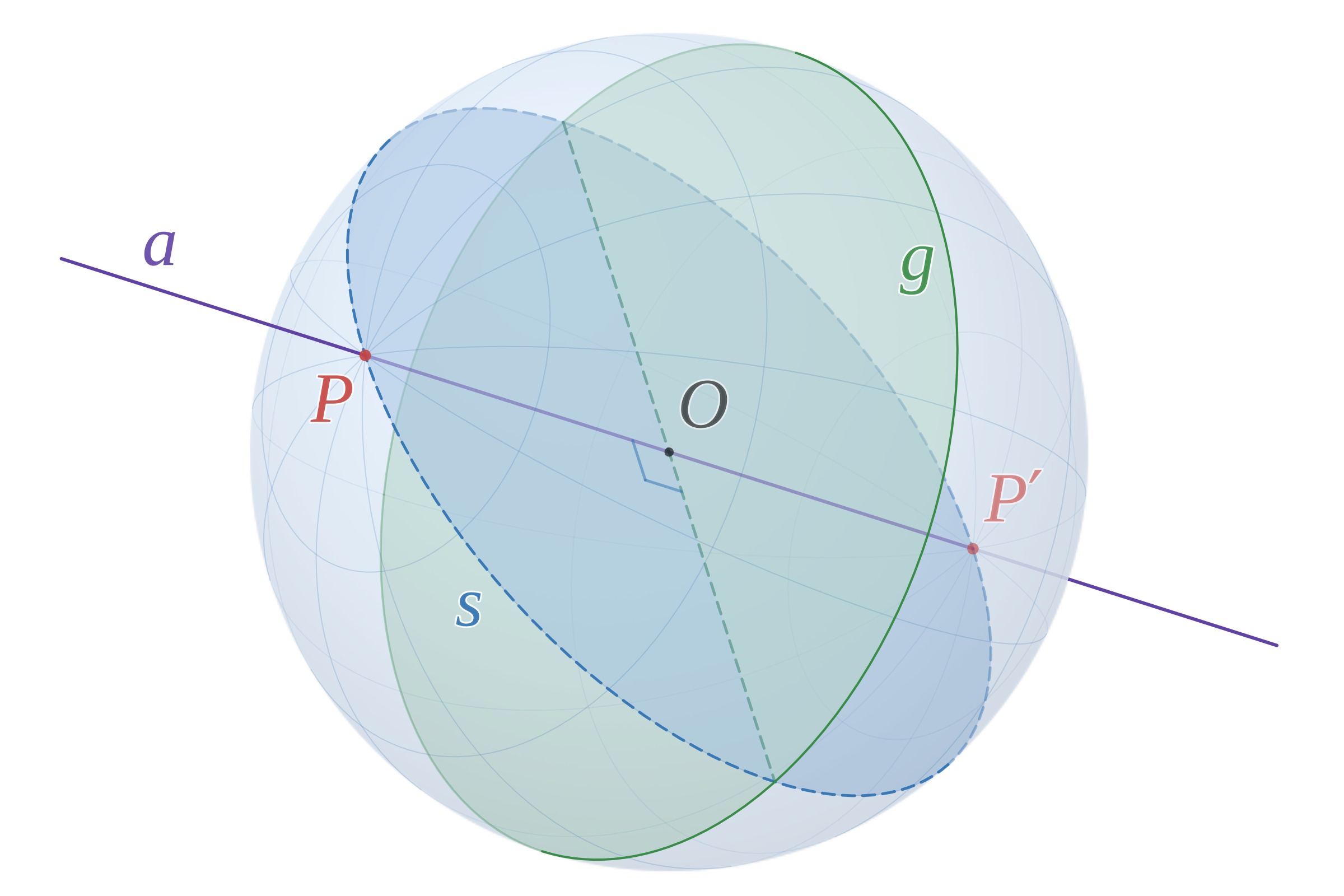
Great Circle
- A circle whose centre coincides with the centre of the Earth.
- Represents the shortest distance between two places.
Examples:
- Equator
- Any pair of opposite longitudes
Small Circle
- Any circle whose centre does not coincide with the Earth’s centre.
Examples:
- All latitudes except the Equator.
Difference Between Latitudes and Longitudes
| Basis | Latitudes | Longitudes |
|---|---|---|
| Orientation | East–West | North–South |
| Shape | Complete circles | Semi-circles |
| Reference Line | Equator | Prime Meridian |
| Measurement | North or South | East or West |
| Maximum Value | 90° | 180° |
| Total Number | 181 (including Equator) | 360 |
| Length | Unequal | Equal |
| Meet at Poles | No | Yes |
| Main Use | Determines climatic zones | Determines local time |
Local Time
- Local Time refers to the time at a particular place based on the position of the Sun.
Earth’s Rotation
- The Earth rotates 360° in 24 hours.
Therefore,
- 15° Longitude = 1 Hour
- 1° Longitude = 4 Minutes
- 1 Minute Longitude = 4 Seconds
Standard Time
- To avoid confusion caused by different local times, countries adopt a Standard Meridian.
Indian Standard Time (IST)
- Standard Meridian: 82°30′ E
- Passes near Mirzapur (Uttar Pradesh).
- IST = UTC + 5 hours 30 minutes
Time Zones
- The Earth is divided into 24 standard time zones, each covering approximately 15° of longitude.
Purpose
- To maintain a uniform time within a country or region.
Examples
- India follows one standard time despite its east-west extent.
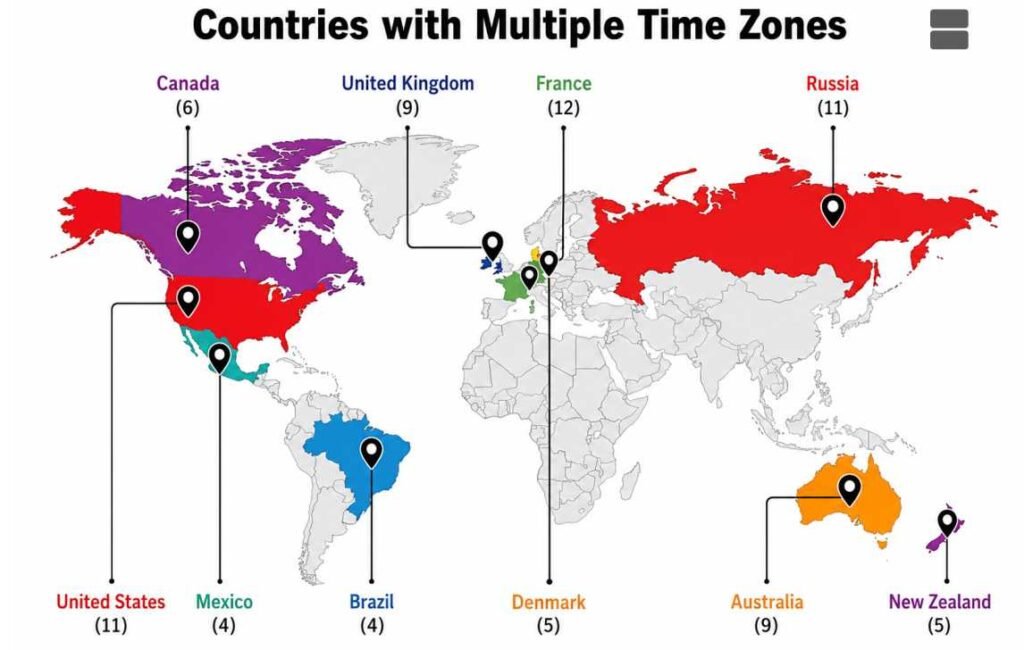
- Russia, USA, Canada, and Australia have multiple time zones.
International Date Line (IDL)
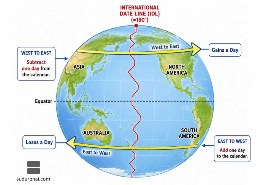
- The International Date Line (IDL) is an imaginary line located approximately along 180° Longitude in the Pacific Ocean.
- It marks the place where the calendar date changes.
Why is it not a Straight Line?
The IDL deviates from 180° longitude to avoid dividing:
- Countries
- Island groups
- Political territories
Examples include:
- Russia
- Alaska (USA)
- Kiribati
- Fiji
- Samoa
Rules of Crossing the International Date Line
Travelling from West to East
- Subtract one day from the calendar.
Example:
- Monday → Sunday
Travelling from East to West
- Add one day to the calendar.
Example:
- Monday → Tuesday
Importance of the International Date Line
The IDL is important because it:
- Maintains a uniform global calendar.
- Prevents confusion in international travel.
- Assists shipping and aviation.
- Facilitates global communication.
- Helps maintain international business schedules.
Greenwich Mean Time (GMT) and Coordinated Universal Time (UTC)
Greenwich Mean Time (GMT)
- Based on the mean solar time at the Prime Meridian (Greenwich, London).
- Traditionally used as the world’s standard time.
Coordinated Universal Time (UTC)
- The modern international time standard.
- Maintained using atomic clocks.
- All national time zones are expressed as UTC offsets.