
Fronts
- Fronts are boundaries that separate air masses with different temperatures.
- They are essentially transition zones, and this transition region is known as a frontal zone. In some cases, the frontal zone may become very sharp.

- Fronts are common features of mid-latitude weather in the temperate regions (30°–65° N and S).
- They are relatively uncommon in tropical and polar regions.
- A front is a three-dimensional boundary zone formed when two converging air masses possess different physical characteristics such as temperature, humidity, and density.
- When contrasting air masses meet, they do not mix easily because of:
- Converging atmospheric circulation
- Low diffusion coefficient
- Low thermal conductivity
- The concept of fronts was introduced by Norwegian meteorologists during World War I.
- The term “front” was used because the interaction of unlike air masses resembled a battlefront between opposing armies.
- As the more dominant or “aggressive” air mass advances, limited mixing occurs within the frontal zone.
- Despite some mixing, the air masses generally retain their separate identities while one displaces the other.
Front Formation
- The formation of a front is called Frontogenesis (development of conflict between two air masses).
- The weakening or disappearance of a front is known as Frontolysis (where one air mass overpowers the other).
- Frontogenesis involves the convergence of two distinct air masses.
- Frontolysis occurs when one air mass overrides another.
- In the Northern Hemisphere, frontogenesis takes place in an anticlockwise direction.
- In the Southern Hemisphere, it occurs in a clockwise direction.
- This directional movement is caused by the Coriolis Effect.
- Mid-latitude cyclones, also known as:
- Temperate cyclones
- Extra-tropical cyclones
are formed due to frontogenesis.
Characteristics of Fronts
- The temperature contrast between air masses affects the thickness of the frontal zone in an inversely proportional manner.
- Greater temperature differences prevent easy mixing, resulting in a thinner front.
- A sudden change in temperature across a front is usually accompanied by a change in atmospheric pressure.
- Fronts are associated with wind shifts because wind movement depends on:
- Pressure Gradient Force
- Coriolis Force
- Wind Shift refers to:
- A change in wind direction of 45° or more
- Occurring within less than 15 minutes
- With sustained wind speeds of 10 knots or more
- Frontal activity is commonly linked with:
- Cloud formation
- Precipitation (rainfall)
- This happens because warm air rises, cools adiabatically, condenses, and produces rainfall.
- The process is related to:
- Adiabatic Lapse Rate
- Latent Heat of Condensation
- The intensity of precipitation depends on:
- The slope of ascent
- The amount of water vapour present in the rising air mass.
Classification of Fronts
- Fronts are classified based on the mechanism of frontogenesis and the weather conditions associated with them.
- The major types of fronts are:
- Stationary Front
- Cold Front
- Warm Front
- Occluded Front

Stationary Front
- A stationary front forms when two air masses are unable to push each other forward, resulting in a stalemate or draw.
- The surface position of the front remains unchanged.
- Winds on both sides of the front blow parallel to the front.
- It occurs when either a warm front or cold front stops moving.
- Once the boundary starts moving again, it may develop into either a warm front or a cold front.
Weather along a stationary front
- Cumulonimbus clouds commonly develop along stationary fronts.
- The overrunning of warm air over cold air produces frontal precipitation.
- Cyclones moving along a stationary front can cause heavy rainfall.
- Prolonged precipitation may lead to serious flooding in nearby regions.

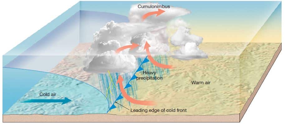
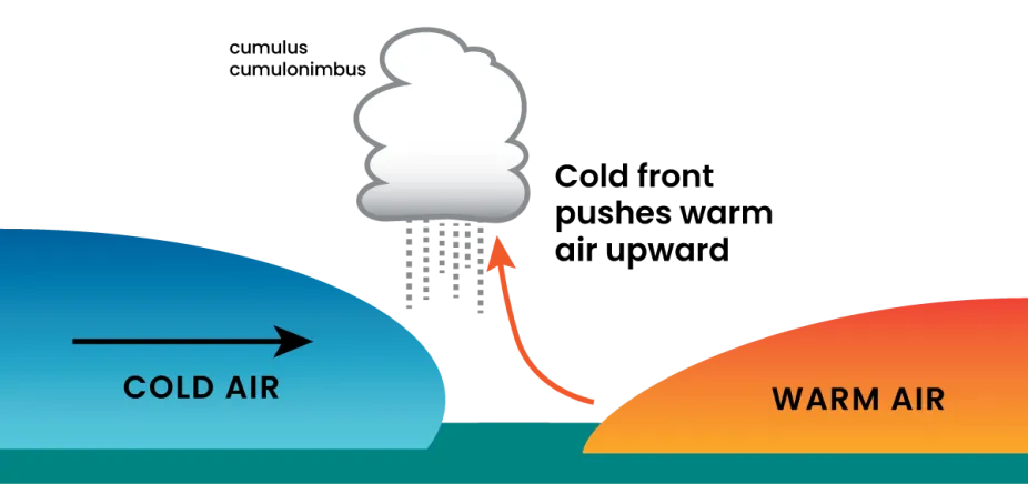
Cold Front
- A cold front forms when a cold air mass advances and replaces a warm air mass.
- It may also occur when the warm air mass retreats while the cold air mass moves forward.
- In this situation, the cold air mass is considered the dominant or winning air mass.
- The boundary separating the two air masses is called a cold front.
- Cold fronts generally move twice as fast as warm fronts.
- Frontolysis begins once the warm air mass is completely uplifted by the advancing cold air.
Weather along a cold front
- Weather conditions are concentrated within a narrow band of clouds and precipitation.
- Severe storms are common along cold fronts.
- During summer, thunderstorms frequently develop in the warm sector.
- In regions such as the USA, cold fronts may trigger tornadoes.
- Cold fronts bring abrupt and intense weather changes.
- Temperatures may fall by more than 15°C within the first hour after the passage of the front.
Cloud formation along a cold front
- The approach of a cold front is marked by:
- Increased wind activity in the warm sector
- Appearance of cirrus clouds
- Followed by denser altocumulus clouds
- At the actual front, nimbus and cumulonimbus clouds develop.
- These clouds produce heavy showers and violent weather conditions.
- A cold front usually passes quickly, but the associated weather is often severe.
Warm Front
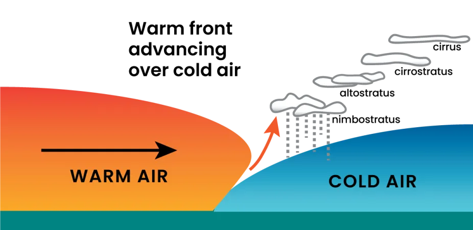
- A warm front is a sloping frontal surface where warm air rises over cold air.
- In this case, the warm air mass is too weak to displace the cold air mass completely.
- Frontolysis starts when the warm air mass completely overrides the cold air mass at the surface.
Weather along a warm front
- As warm air gradually ascends over cold air, it cools, condenses, and causes precipitation.
- Unlike cold fronts, changes in temperature and wind direction are more gradual.
- Warm fronts generally produce moderate to gentle rainfall over a wide area.
- The precipitation may continue for several hours.
- The passage of a warm front is marked by:
- Rise in temperature
- Increase in pressure
- Gradual change in weather conditions
Clouds along a warm front
- Clouds appear in the following sequence during the approach of a warm front:
- Cirrus clouds
- Stratus clouds
- Nimbus clouds
- Cumulonimbus clouds are generally absent because the slope is gentle.
- Cirrostratus clouds often create a halo around the Sun and Moon.
Occluded Front
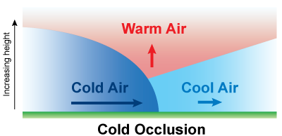
- Occlusion is the process in which the cold front overtakes the warm front in a rotating low-pressure system.
- The warm air trapped between them is forced upward.
- An occluded front forms when a cold air mass catches up with and moves beneath a warm air mass.
- Frontolysis begins when the warm sector shrinks and the cold air mass completely occupies the ground surface.
- This creates a long, backward-swinging occluded front.
- Occlusions may be of two types:
- Warm-type occlusion
- Cold-type occlusion
Weather along an occluded front
- Weather along an occluded front is highly complex because it combines features of both cold front and warm front weather.
- Occluded fronts are especially common in Western Europe.
- The development of mid-latitude cyclones (temperate or extra-tropical cyclones) involves the formation of occluded fronts.
Clouds along an occluded front
- Clouds along an occluded front are a combination of warm front and cold front clouds.
- Warm front clouds and cold front clouds are usually found on opposite sides of the occlusion.
Air Masses, Fronts, and Major Atmospheric Disturbances
- Major atmospheric disturbances occur within the framework of the general circulation of the atmosphere.
- Most disturbances are associated with unsettled or violent weather conditions and are referred to as storms.
- Some disturbances, however, produce calm, clear, and stable weather.
- Many disturbances are linked with:
- Air mass contrasts
- Fronts
- Migrating pressure systems
Common characteristics of atmospheric disturbances
- They are smaller in scale than the major components of general circulation.
- They are migratory in nature.
- Their duration is relatively short, lasting from:
- A few minutes
- A few hours
- A few days
- They produce distinct and predictable weather conditions.
Midlatitude Disturbances
- The midlatitudes are considered the main battleground of tropospheric activity.
- These regions witness the meeting of polar and tropical air masses.
- Most fronts occur in the midlatitudes.
- Weather conditions here are highly dynamic and changeable from day to day and season to season.
- Important atmospheric disturbances in this region include:
- Midlatitude cyclones
- Midlatitude anticyclones
- These systems are significant because of their large size and frequent occurrence.
Tropical Disturbances
- Tropical regions generally experience uniform and monotonous weather throughout the year.
- Temporary changes are mainly caused by transient atmospheric disturbances.
- The most important tropical disturbances are:
- Tropical cyclones
- Hurricanes (when tropical cyclones intensify)
- Easterly waves
- Tropical cyclones are the most intense and destructive disturbances in low latitudes.
Localized Severe Weather
- Several short-lived but severe atmospheric disturbances occur in different parts of the world.
- Common examples include:
- Thunderstorms
- Tornadoes
- These disturbances often develop alongside larger storm systems and can produce highly destructive weather conditions.