Barpeta District
INDEX
1. District Overview
2. History of Barpeta District
3. Geography of Barpeta District
4. Socio-Economy of Barpeta District
5. Transport in Barpeta District
6. Demographics of Barpeta District
7. Administrative Setup of Barpeta District
8. Tourist Places in Barpeta District
9. Languages Spoken in Barpeta District
Overview of Barpeta District
Formation
- Established in 1983.
- Renowned for its rich cultural heritage and historical significance.
Headquarters
- Located in Barpeta town, known as “Satra Nagari” (Temple Town of Assam) due to its numerous Vaishnavite Satras.
Geographical Area
- Covers approximately 3,245 square kilometers.

History of Barpeta
1. Ancient & Medieval Periods
- Part of Ancient Kamrup, ruled by various dynasties:
- Varmans (380-654 CE)
- Salasthamas (655-985 CE)
- Palas (985-1260 CE)
- Kamatas (1260-1509 CE)
- Koches (1509 onwards)
- Koch-Hajo State:
- Flourished under King Naranarayan.
- Mahapurush Shrimanta Sankardeva established Satras (monasteries), shaping the region’s cultural identity.
- Part of Ancient Kamrup, ruled by various dynasties:
2. Mughal & British Rule
- Mughal Invasion (17th century):
- Introduced systematic revenue collection.
- Issued land grants for Satras.
- Burmese Invasions (Early 19th century):
- Widespread destruction, including Barpeta Satra.
- British intervention restored order.
- British Administration (1841):
- Barpeta became a Civil Sub-Division under John Batlor.
- Increased land revenue, leading to peasant unrest.
- Lachima Uprising (1893-94) in response to heavy taxation.
- Mughal Invasion (17th century):
Geography of Barpeta
- Location: Western part of Assam, India.
Situated along Northern bank of Brahmaputra - Area: Approximately 3,245 square kilometers.
- Topography: Low-lying with an average elevation of about 35 meters.
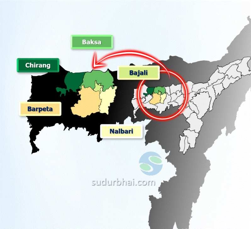
- Boundaries:
- North: Baksa and Bajali districts
- East: Nalbari district
- South: Kamrup and Goalpara districts
- West: Bongaigaon district
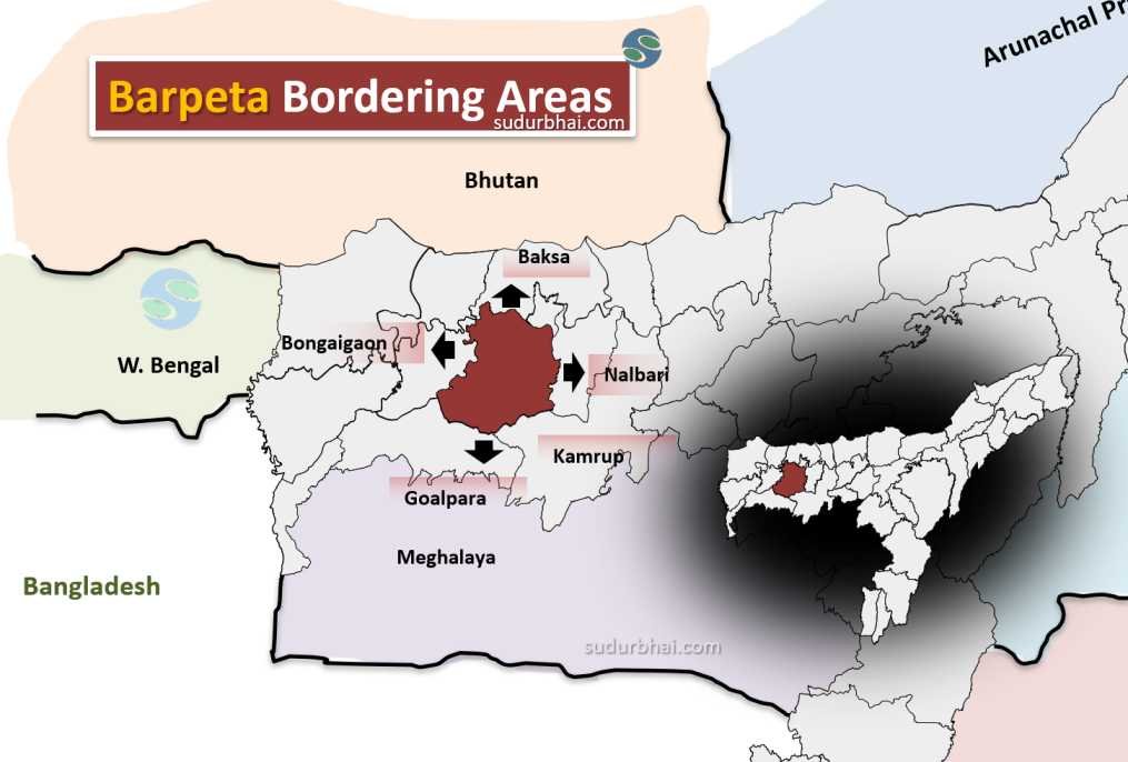
Barpeta nearby districts
- Rivers: Chaulkhowa, Mora, Nodi (tributaries of the Brahmaputra River),Nakhanda.
- Beel : Velekee,Vela, Gora ,Bahuwa, chilla
- Notable Sites: Gateway to Manas National Park, a UNESCO World Heritage site.
- Climate: Subtropical climate with distinct seasons.
- Average Annual Rainfall: Approximately 1,700 mm.
- Wettest Month: July.
- Seasons:
- Winters: Chilly
- Summers: Hot
- Location: Western part of Assam, India.
Socio-Economy of Barpeta District
- Economy: Primarily agrarian, with most people dependent on agriculture.
- Main Products: Rice, jute,mustard and various vegetables.
- Local Trade: Several markets and bazaars support local trade.
- Industries: Small-scale industries contribute to the economy.
- Handicraft : Known for bell-metal crafts from Sarthebari.
- Cultural Influence: Rich cultural heritage linked to Vaishnavism, which also boosts tourism through religious sites.
Transport in Barpeta District
- Rail Connectivity: Nearest railway station is Barpeta Road, linking the district to major cities in Assam.
- Road Connectivity: Accessible via National Highway 31, connecting to Guwahati and other regions.
- Air Connectivity: Nearest airport is Lokpriya Gopinath Bordoloi International Airport in Guwahati.
Demographics of Barpeta District
- Total Population: 1,693,622
- Male Population: 867,004 (51.1%)
- Female Population: 826,618 (48.9%)
- Sex Ratio: 951 females for every 1000 males
- Population Density: 632 inhabitants per square kilometer
- Literacy Rate:
- Overall: 90.77%
- Male: 94.86%
- Female: 86.73%
- Child Population (0-6 years):
- Total Children: 287,829
- Male Children: 146,777
- Female Children: 141,052
- Child Sex Ratio: 961 girls for every 1000 boys
- Child Population Percentage (0-6 years): 16.99% of total population
- Scheduled Castes (SC): Approximately 19.66% of the population
- Scheduled Tribes (ST): Approximately 0.28% of the population
- Total Children: 287,829
Urban and Rural Distribution
- Urban Population: Approximately 147,353 (8.70% of total population)
- Rural Population: Approximately 1,546,269 (91.30% of total population)
Religious Composition
- Hindus: Approximately 40.19%
- Muslims: Approximately 59.37%
- Other religions account for a small percentage, including Christians, Sikhs, Buddhists, and Jains.
Administrative Setup of Barpeta District
- Administrative Headquarters: Barpeta town.
- Sub-Divisions and Revenue Circles: The district is divided into several sub-divisions and revenue circles.
- Development Blocks: 9 development blocks.
- Focus: Governance and development initiatives to improve infrastructure and public services.
Attractive Tourist Places
- Barpeta Satra: A prominent Vaishnavite monastery established by Madhabdev.
- Manas National Park: Known for its rich biodiversity and wildlife.
- Sarthebari: Famous for traditional bell-metal crafts.
- Temples and Cultural Sites: Various temples and cultural sites reflecting Assam’s heritage.
- Kirtan Ghar – a prominent Vaishnavite shrine and biggest Vaishnavite monastery of Assam.
Languages Spoken in Barpeta
Language | Percentage of Population |
---|---|
Bengali | 68.89% |
Assamese | 29.39% |
Bodo | 1.03% |
Others | 0.69% |
Let us know any further suggestions ,we at sudurbhai.com will be happy to hear from you in our comment section below !