Udalguri District

District Overview: Udalguri

    • Location: Part of the Bodoland Territorial Region in Assam, India.
    • Established: June 14, 2004 (formed from Darrang district).
    • Headquarters: Udalguri town.
    • Significance: Known for its rich culture, diverse communities, and agricultural activities.

History of Udalguri

Origin of the Name

    • Derived from “Odal” (a tree) + “Goor/Guri” (roots or surroundings), meaning a place surrounded by Udal trees.

    • Some believe it refers to a location centered around an Odal tree.

    • Another theory links it to the Bodo words “ORDLA” (wide/spacious) and “GUNDRI” (powdered object), evolving into “Odal Guri” (still pronounced as such by Bodos).

Early History & Trade

    • Located in Darrang Duars, specifically Buriguma Dooar and Killing Dooars.

    • Served as a trade hub between Assam and Tibet (now China), with routes passing through Nyamjang Chu and Tawang Chu rivers.

    • Monpas from Tibet visited Tangla and Udalguri to trade silk with Bodos and Ravas, weaving and selling the final product in Tibet and Arunachal Pradesh.

Governance

    • 17th century: Jointly ruled by Bhutan’s Druk Desi and Ahom King Sutamla.

    • 1841: British East India Company ended Bhutanese rule in the area.

    • 1949: Merged into undivided Darrang district.

Modern History

    • 1932-33: Railway extended from Tangla to Udalguri to Rangapara, with passenger trains starting in 1935.

    • 1942: Udalguri played a role in India’s Independence Movement, with Congress leaders from Darrang mobilizing local support.

    • 2011: District Judiciary established (September 29).

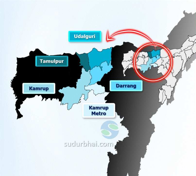
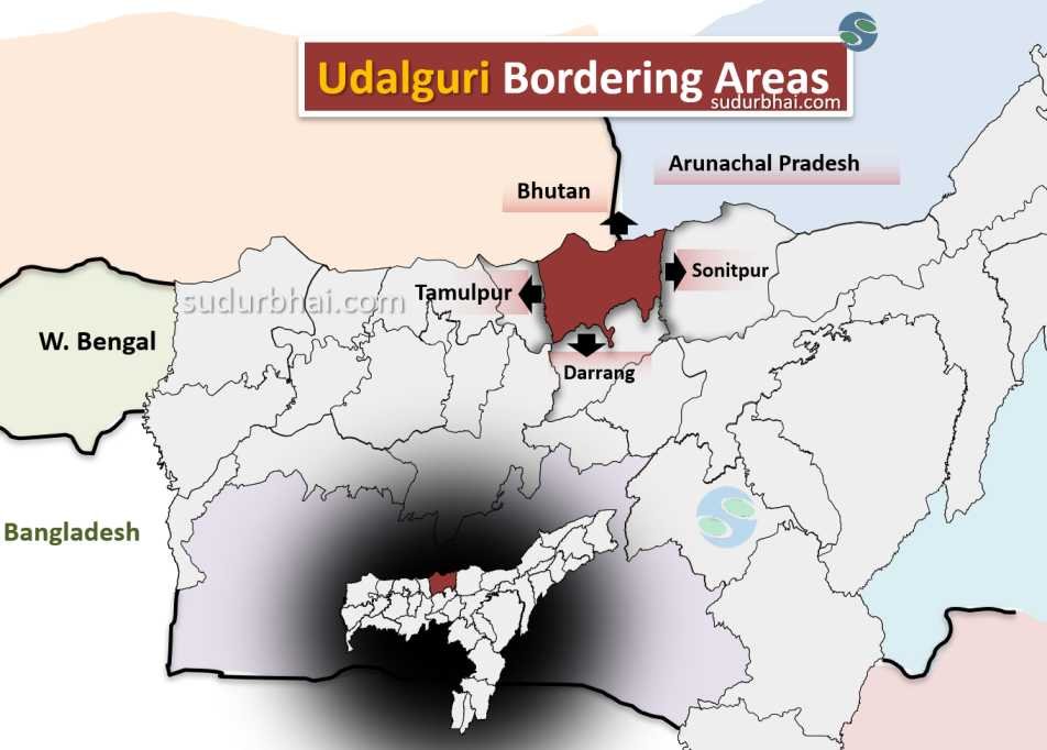
    • Pre-district status: Was a civil subdivision under Darrang district.

    • 2003: Bodoland Territorial Council (BTC) was formed after a Tripartite Peace Agreement involving Bodo Liberation Tigers, Government of India, and Government of Assam.

    • BTC creation: Led to the formation of Bodoland Territorial Autonomous District (BTAD), with Udalguri as one of its four districts.


Geography of Udalguri

    • Area: 1,852.16 square kilometers (715.77 square miles).
    • Coordinates: Approximately 26°44′ N latitude and 92°05′ E longitude.
    • Boundaries:
      • North: Borders Bhutan.
      • South: Shares boundary with Darrang district.
      • East: Adjacent to Sonitpur district.
      • West: Borders Baksa district.
    • Topography: Mainly flat plains with some hills and valleys. The district has low-lying areas that are prone to flooding, especially during the monsoon season.
    • Rivers: Major rivers include Bamodi, Dipila, and Jiya Dhansiri.
    • Climate: Humid subtropical climate with hot summers and mild winters. Average rainfall is about 2,000 mm (mostly during the monsoon from June to September).

Socio-Economy of Udalguri

    • Agriculture: Agriculture is the backbone of Udalguri’s economy. Key crops include rice, jute, mustard, tea, and various vegetables. The region also grows oranges and bananas.
    • Livestock: Dairy farming, poultry, and goat rearing are common.
    • Industries: The industrial sector includes small-scale businesses like food processing, bamboo crafts, and handicrafts.
    • Commerce: Local markets are essential for trade, particularly in agricultural products and handicrafts.

Transport in Udalguri

    • Roadways: Well-connected by roads linking it to major cities in Assam. State highways help in internal travel.
    • Railways: The nearest railway station is Tangla, about 20 km away, providing access to other regions.
    • Airways: The nearest airport is in Guwahati, about 120 km from Udalguri.

Demographics of Udalguri

Population

    • Total Population: 831,668

      • Male: 421,617

      • Female: 410,051

    • Percentage of Assam’s Population: 2.67%

    • Rural Population: 794,094 (95.48%)

      • Male: 402,442

      • Female: 391,652

    • Urban Population: 37,574 (4.52%)

      • Male: 19,175

      • Female: 18,399

Sex Ratio

    • Overall: 973 females per 1000 males

    • Rural: 973 females per 1000 males

    • Urban: 960 females per 1000 males

Literacy Rate

    • Overall Literacy: 65.41%

      • Male: 72.58%

      • Female: 58.05%

    • Rural Literacy: 64.43%

      • Male: 71.75%

      • Female: 56.92%

    • Urban Literacy: 85.14%

      • Male: 89.08%

      • Female: 81.03%

Child Population (0-6 years)

    • Total: 113,274 (13.62% of the population)

      • Male: 57,410

      • Female: 55,864

    • Rural Child Population: 109,653

    • Urban Child Population: 3,621

    • Child Sex Ratio: 973 females per 1000 males

      • Rural: 972 females per 1000 males

      • Urban: 994 females per 1000 males

Other Demographics

        • Scheduled Castes: 4.55% of the population

        • Scheduled Tribes: 32.15% of the population


Administrative Setup of Udalguri

      • District Headquarters: Udalguri town.

      • Sub-Divisions: The district has two sub-divisionsUdalguri and Bhergaon.

      • Revenue Circles: There are five revenue circles: Udalguri, Majbat, Harisinga, Kalaigaon, and Khoirabari.

      • Development Blocks: There are eleven development blocks that focus on local governance and development.


Rainfall in Udalguri

    • Average Annual Rainfall: 2,000 mm to 2,500 mm, with the heaviest rainfall occurring during the monsoon months.
    • Impact: Heavy rainfall contributes to fertile soil for farming but can cause flooding in low-lying areas.

Attractive Tourist Places in Udalguri

    • Wildlife Sanctuaries & National Parks

      • Manas National Park: UNESCO World Heritage Site, rich in biodiversity, home to the Great Indian One-Horned Rhinoceros.

      • Sonai Rupai Wildlife Sanctuary: Near Udalguri, known for diverse flora and fauna.

      • Bornadi Wildlife Sanctuary: At the Himalayan foothills, home to tigers, elephants, and leopards.

      • Orang National Park: Famous for rhinoceroses, offers scenic landscapes along the Brahmaputra River.

      Religious & Cultural Sites

      • Bhairabkunda: Hindu pilgrimage site with a Shiva temple at the Bhutan-Assam-Arunachal Pradesh tri-junction; also a picnic spot.

      • Bathou Temple: Dedicated to the Bathou religion, reflecting Bodo cultural heritage.

      • Old Namghar: Traditional Assamese worship place showcasing local architecture.

      • Old Hanuman Temple: Religious site in Udalguri town attracting devotees.

      • Gethsemane Man-made Forest (Bhairabkunda): A serene, man-made forest ideal for nature walks.


Languages Spoken in Udalguri

    • Boro: 26.90%
    • Assamese: 22.62%
    • Bengali: 19.43%
    • Sadri: 7.88%
    • Nepali: 5.60%
    • Santali: 2.79%
    • Odia: 2.64%
    • Kurukh: 2.08%
    • Hindi: 1.66%
    • Mundari: 1.57%
    • Bhojpuri: 1.45%

Let us know any further suggestions ,we at sudurbhai.com will be happy to hear from you in our comment section below ! 

Leave a Comment

Your email address will not be published. Required fields are marked *

Scroll to Top