
Tsunami
- A Tsunami is a series of large, long-wavelength ocean waves generated by the sudden displacement of a massive volume of water, usually due to an undersea earthquake, volcanic eruption, submarine landslide, or meteorite impact.
- Unlike ordinary sea waves generated by wind, tsunamis are generated by geological disturbances.
- The word “Tsunami” is derived from the Japanese words:
- Tsu = Harbour
- Nami = Wave. Hence, Tsunami literally means “Harbour Wave.”
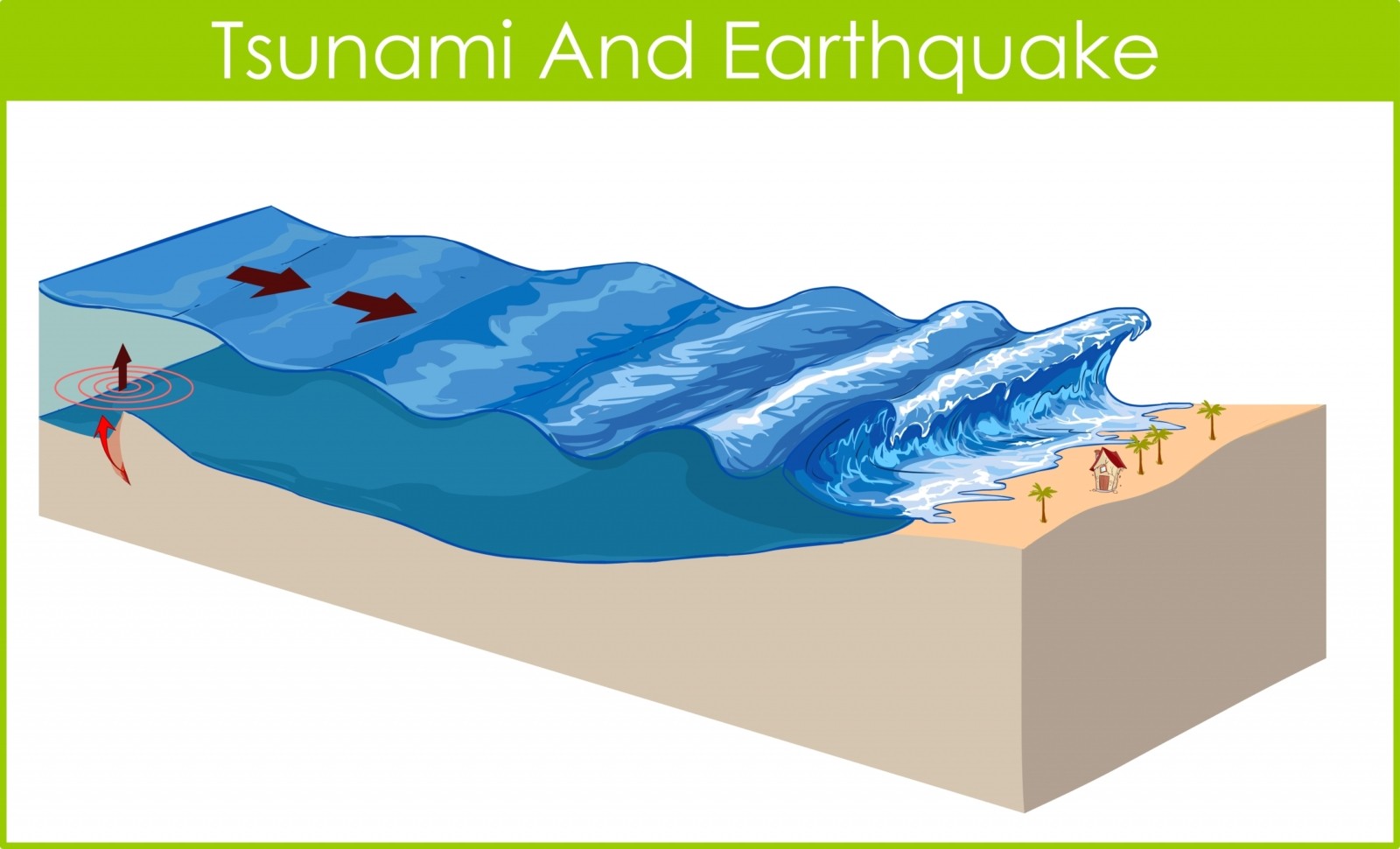
Characteristics of Tsunami
Wave Length
- Extremely long, ranging from 100 km to over 500 km.
Wave Height
- In the open ocean, wave height is generally less than 1 metre.
- Near the coast, wave height may increase to 10–30 metres or even more.

Wave Speed
Depends upon ocean depth.
- Deep Ocean: 500–900 km/hr
- Near Coast: Speed decreases significantly.
Wave Frequency
- Successive waves may arrive 5 to 60 minutes apart.
- The first wave is not always the largest.
Water Movement
- A tsunami involves the movement of the entire water column, from the ocean surface to the seabed.
Causes of Tsunami
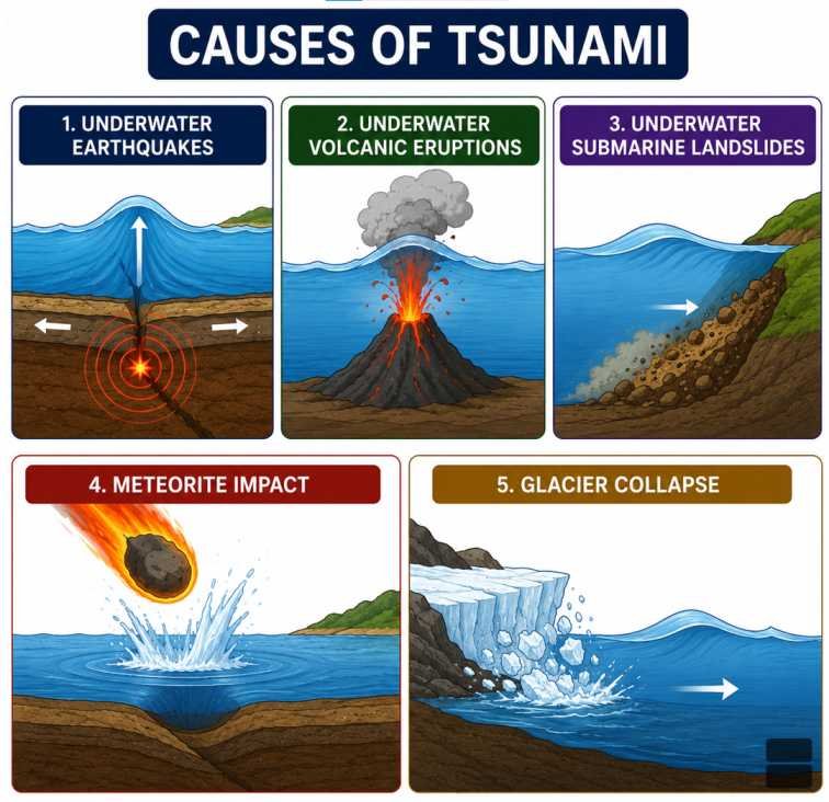
Underwater Earthquakes
- The most common cause of tsunamis.
- Usually generated by earthquakes of Magnitude 7.5 or above.
- Occur mainly along Subduction Zones.
Example
- 2004 Indian Ocean Tsunami
- 2011 Japan Tsunami
Volcanic Eruptions
- Violent volcanic eruptions beneath or near the sea can displace enormous quantities of water.
Examples
- Krakatoa (1883)
- Hunga Tonga–Hunga Ha’apai (2022)
Submarine Landslides
- Sudden collapse of underwater slopes can generate local tsunamis.
Meteorite Impact
- Rare but capable of producing extremely large tsunamis by displacing vast quantities of ocean water.
Glacier Collapse
- Rapid collapse of glaciers into oceans or fjords can generate localized tsunamis.
Conditions Necessary for Tsunami Generation
A tsunami is most likely when:
- An earthquake occurs beneath the ocean.
- Magnitude is generally greater than 7.5 Mw.
- The movement is vertical rather than horizontal.
- Large quantities of water are displaced.
- Earthquake occurs at shallow depth.
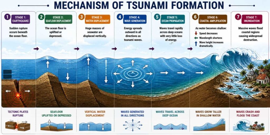
Mechanism of Tsunami Formation
Stage 1: Earthquake
- Sudden rupture occurs beneath the ocean floor.
Stage 2: Seafloor Displacement
- The ocean floor is uplifted or depressed.
Stage 3: Water Displacement
- Huge masses of seawater are displaced vertically.
Stage 4: Wave Generation
- Energy spreads outward in all directions as tsunami waves.
Stage 5: Ocean Propagation
- Waves travel rapidly across deep oceans with very little loss of energy.
Stage 6: Coastal Amplification
- As water becomes shallow:
- Speed decreases.
- Wavelength shortens.
- Wave height increases dramatically.
Stage 7: Inundation
- Massive waves flood coastal regions causing widespread destruction.
Types of Tsunami
Local Tsunami
- Originates close to the affected coastline.
- Reaches shore within minutes.
- Leaves very little warning time.
Regional Tsunami
- Travels several hundred kilometres.
- May take 1–3 hours to reach affected areas.
Distant (Tele-Tsunami)
- Travels across entire ocean basins.
- May require several hours before reaching distant coastlines.
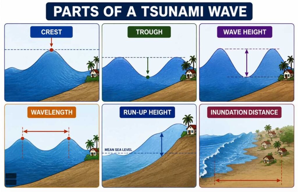
Parts of a Tsunami Wave
Crest
- Highest point of the wave.
Trough
- Lowest point of the wave.
Wave Height
- Vertical distance between crest and trough.
Wavelength
- Horizontal distance between successive crests.
Run-up Height
- Maximum vertical height reached by tsunami water above mean sea level.
Inundation Distance
- Maximum inland distance travelled by tsunami waters.
Difference Between Tsunami and Ordinary Sea Waves
| Feature | Tsunami | Ordinary Sea Waves |
|---|---|---|
| Cause | Earthquakes, Volcanoes, Landslides | Wind |
| Wavelength | 100–500 km | Few metres to hundreds of metres |
| Speed | 500–900 km/hr | 10–70 km/hr |
| Energy Source | Seafloor displacement | Wind energy |
| Water Movement | Entire water column | Surface water only |
| Destructive Nature | Extremely destructive | Usually less destructive |
Tsunami-Prone Regions of the World
Major tsunami-prone regions include:
- Pacific Ring of Fire
- Japan
- Indonesia
- Philippines
- Chile
- Alaska
- New Zealand
- Western Coast of North America
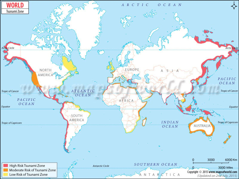
Tsunami Risk in India
India is vulnerable due to its long coastline.
Highly vulnerable areas include:
- Andaman & Nicobar Islands
- Eastern Coast
- Tamil Nadu
- Andhra Pradesh
- Odisha
- Kerala
- Lakshadweep
- Gujarat Coast (moderate risk)
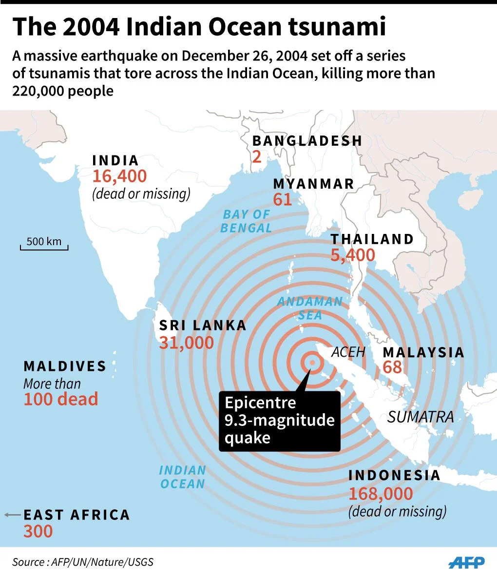
Indian Ocean Tsunami (2004)
Date
- 26 December 2004
Cause
- Magnitude 9.1–9.3 Megathrust Earthquake near Sumatra, Indonesia.
Effects
- More than 2.3 lakh deaths across 14 countries.
- India, Indonesia, Sri Lanka, Thailand, Maldives and Somalia were severely affected.
India
Affected regions:
- Tamil Nadu
- Andaman & Nicobar Islands
- Andhra Pradesh
- Kerala
- Puducherry
2011 Japan Tsunami
Date
- 11 March 2011
Cause
- Magnitude 9.1 Earthquake off the coast of Tohoku.
Effects
- Severe destruction.
- Triggered the Fukushima Daiichi Nuclear Disaster.
- More than 18,000 people died or went missing.
Tsunami Warning System
Purpose
To provide early warning before tsunami waves reach the coast.
Components
- Seismographs
- Ocean Bottom Pressure Sensors
- DART Buoys
- Tide Gauges
- Satellite Communication
- Numerical Models
Indian Tsunami Warning Centre
India established the Indian Tsunami Early Warning Centre (ITEWC) at:
- INCOIS
- Hyderabad
Functions:
- Earthquake detection.
- Tsunami forecasting.
- Warning dissemination.
- Monitoring Indian Ocean region.
Warning Signs of a Tsunami
Natural warning signs include:
- Strong coastal earthquake.
- Sudden withdrawal of sea water.
- Loud roaring sound from the sea.
- Unusual rise or fall of sea level.
Effects of Tsunami
Primary Effects
- Coastal flooding.
- Destruction of buildings.
- Loss of human life.
- Damage to ports.
- Infrastructure collapse.
Secondary Effects
- Soil salinisation.
- Water contamination.
- Disease outbreaks.
- Displacement of people.
- Economic losses.
- Ecosystem destruction.
Environmental Impacts
- Coastal erosion.
- Destruction of mangroves.
- Coral reef damage.
- Habitat loss.
- Saltwater intrusion into groundwater.
- Loss of biodiversity.
Economic Impacts
- Damage to fisheries.
- Tourism losses.
- Agricultural land degradation.
- Port destruction.
- Huge reconstruction costs.
Tsunami Preparedness
Before Tsunami
- Hazard mapping.
- Early warning systems.
- Public awareness.
- Coastal zoning.
- Evacuation planning.
During Tsunami
- Move immediately to higher ground.
- Stay away from beaches.
- Follow official evacuation routes.
- Do not return after the first wave.
After Tsunami
- Wait for official clearance.
- Avoid floodwater.
- Assist injured people.
- Ensure safe drinking water.
- Inspect buildings before entry.
Tsunami Mitigation Measures
Structural Measures
- Tsunami shelters.
- Sea walls.
- Elevated buildings.
- Coastal embankments.
- Mangrove plantation.
Non-Structural Measures
- Early warning systems.
- Disaster education.
- Community drills.
- Coastal Regulation Zone (CRZ) management.
- Land-use planning.
Role of Mangroves and Coral Reefs
Mangroves
- Reduce wave energy.
- Minimise coastal erosion.
- Protect coastal settlements.
Coral Reefs
- Act as natural offshore barriers.
- Dissipate wave energy before reaching the coast.
Important Organisations
| Organisation | Role |
|---|---|
| INCOIS | Indian Tsunami Early Warning Centre |
| UNESCO-IOC | Global Tsunami Warning Coordination |
| NOAA (USA) | Pacific Tsunami Warning System |
| NDMA | Disaster management in India |
| IMD | Seismic monitoring and earthquake information |
Major Tsunamis in History
| Year | Location | Cause |
|---|---|---|
| 1755 | Lisbon, Portugal | Earthquake |
| 1883 | Krakatoa, Indonesia | Volcanic Eruption |
| 1946 | Aleutian Islands | Earthquake |
| 1960 | Chile | Magnitude 9.5 Earthquake |
| 2004 | Indian Ocean | Magnitude 9.1–9.3 Earthquake |
| 2011 | Japan (Tohoku) | Magnitude 9.1 Earthquake |
| 2022 | Tonga | Volcanic Eruption |