Location and Boundaries of Assam

Location and Boundaries of Assam

Geographical Location of Assam

    Latitudinal Extent of Assam

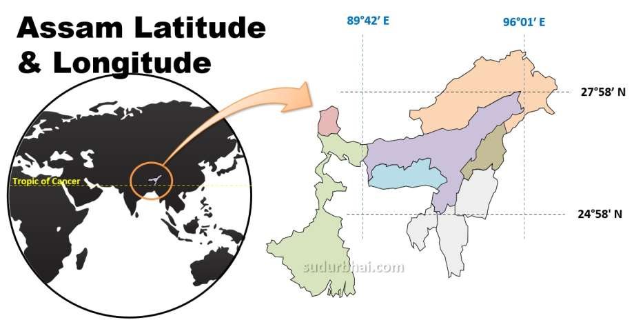
      • Assam lies between 24°08′ N to 28°02′ N latitudes

      • Entirely located in sub-tropical zone

      • Close proximity to the Tropic of Cancer (23½° N) influences:

            • High summer temperatures
            • Strong monsoonal rainfall
            • Dense vegetation cover

Assam Latitude Longitude - Location of Assam | sudurbhai.com
    Longitudinal Extent
of Assam

      • Extends from 89°42′ E to 96°02′ E longitudes

      • Lies in the eastern part of India

      • Experiences early sunrise compared to western India. [one of the important reason for the demand of adoption of Tea Garden Time (Cha Bagan Time)]

    Areal Extent of Assam

      • Total geographical area: 78,438 sq km

      • Ranks 16th among Indian states by area.

      • Ranks 15th among Indian states by population.
      • Accounts for about 2.4% of India’s total geographical area

      • Among North-East Indian States;
        • Area wise, Assam = 2nd Largest state of N-E India
          [Area of NE states (decreasing order) : Arunachal Pradesh > Assam > Meghalaya > Manipur > Mizoram > Nagaland > Tripura]
        • Population wise , Assam = Largest State of N-E India.
          [Population of NE states (decreasing order) : Assam > Tripura > Meghalaya > Manipur > Nagaland >   Arunachal Pradesh > Mizoram > Sikkim]
Sl. No.StateArea (km²)
1Rajasthan342,239
2Madhya Pradesh308,252
3Maharashtra307,713
4Uttar Pradesh240,928
5Gujarat196,024
6Karnataka191,791
7Andhra Pradesh160,205
8Odisha155,707
9Chhattisgarh135,191
10Tamil Nadu130,058
11Telangana112,077
12Bihar94,163
13West Bengal88,752
14Arunachal Pradesh83,743
15Jharkhand79,714
16Assam78,438
17Himachal Pradesh55,673
18Uttarakhand53,483
19Punjab50,362
20Haryana44,212
21Kerala38,863
22Meghalaya22,429
23Manipur22,327
24Mizoram21,081
25Nagaland16,579
26Tripura10,486
27Sikkim7,096
28Goa3,702

    Physiographic Setting of Assam

      • Assam is located in the central part of North-East India

      • Forms the core of the Brahmaputra Valley

      • Acts as a transitional zone between:

        • Indian Peninsular Plateau

        • Eastern Himalayan Mountain System

        • Indo-Myanmar ranges

Strategic and Geopolitical Location

    Gateway to North-East India

      • Assam acts as the “Gateway of North-East India”

      • The Siliguri Corridor (Chicken’s Neck) connects Assam with mainland India

        • Width: ~22–25 km at the narrowest point

        • Strategic vulnerability and importance

    International Proximity

      • Assam lies close to international borders, enhancing:

        • Strategic importance

        • Security concerns

        • Cross-border trade potential

      • Neighbouring countries nearby:

        • Bhutan (north)

        • Bangladesh (south)

    Significance in Act East Policy

      • Assam is a key state under India’s Act East Policy

      • Serves as a corridor linking India with:

        • South-East Asia

        • ASEAN countries via Myanmar

Boundaries of Assam

International Boundaries of Assam

Country Direction
Bhutan
North
Bangladesh
South
  • Assam districts sharing border with Bhutan : 5 Districts
    • Kokrajhar
    • Chirang (Lengthiest Border)
    • Baksa
    • Tamulpur (Shortest Border)
    • Udalguri
  • Assam districts sharing border with Bhutan in increasing order (Shortest to lengthiest border): Tamulpur < Baksa < Udalguri < Kokrajhar < Chirang
  • Assam districts sharing border with Bhutan in decreasing order (Lengthiest to Shortest border): Chirang > Kokrajhar > Udalguri >Baksa > Tamulpur

Inter-State Boundaries of Assam

State Direction
Arunachal Pradesh
North
Nagaland
South
Manipur
East
Mizoram
East
Tripura
South
Meghalaya
South
West Bengal
West
  • 8 Assam districts sharing boundary with Arunachal Pradesh (decreasing order): Tinsukia > Dhemaji > Lakhimpur > Biswanath >  Sonitpur  > Dibrugarh > Udalguri > Charaideo.
  • 6 Assam districts sharing boundary with Nagaland (decreasing order):

    Jorhat > Golaghat > Karbi Anglong > Sivasagar > Dima Hasao > Charaideo

  • 2 Assam districts sharing boundary with Manipur (decreasing order):

    Cachar > Dima Hasao

  • 3 Assam districts sharing boundary with Mizoram (decreasing order):

    Hailakandi > Cachar > Sribhumi (Karimganj)

  • 1 Assam districts sharing boundary with Tripura : Sribhumi
  • 8 Assam districts sharing boundary with Meghalaya (decreasing order):

    Kamrup > Goalpara > West Karbi Anglong > Dima Hasao > South Salmara Mankachar > Kamrup(M) > Cachar > Morigaon

  • 2 Assam districts sharing boundary with West Bengal (decreasing order):

    Dhubri > Kokrajhar

Note

8 Assam Districts donot share their border with any neighbouring state/ Countries :

    • Bongaigaon
    • Borpeta
    • Bajali
    • Nalbari
    • Nagaon
    • Hojai
    • Darrang
    • Majuli

Assam’s Location in Relation to Major Physical Features

Himalayan Influence

    • Northern Assam influenced by:

      • Eastern Himalayas

      • Heavy orographic rainfall

      • Flash floods

Indo-Myanmar Ranges

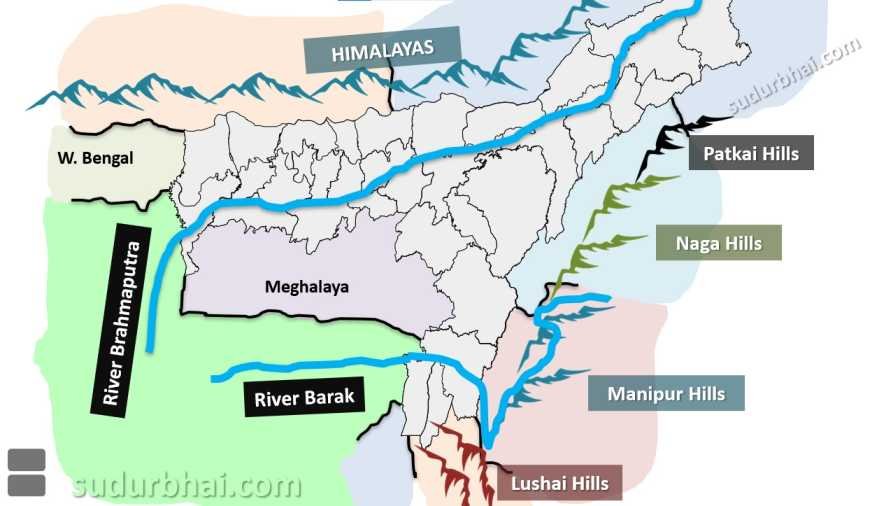
    • Eastern and southern boundaries defined by:

      • Patkai Hills

      • Naga Hills

      • Lushai Hills

    • Act as:

      • Climatic barrier

      • Cultural divide

Assam Physiographic boundaries - Patkai hills, Naga Hills, Manipur Hills, Lushai Hills | sudurbhai.com

River Systems and Boundaries

    • Brahmaputra Valley dominates central Assam

    • Barak Valley lies in southern Assam

    • Rivers act as:

      • Natural boundaries

      • Communication routes

      • Flood hazards

Importance of Location and Boundaries 

Economic Importance

    • Facilitates tea cultivation due to:

      • Location in humid tropics

      • Alluvial soils

    • Strategic for:

      • Inland waterways (NW-2)

      • Oil and natural gas exploration

Political and Administrative Importance

    • Boundary disputes affect:

      • Federal relations

      • Internal security

    • Location necessitates:

      • Strong border management

      • Infrastructure development

Environmental Importance

    • Assam’s boundaries encompass:

      • Biodiversity hotspots

      • National Parks (Kaziranga, Manas)

    • Vulnerable to:

      • Floods

      • Earthquakes (Seismic Zone VI)

Q. How much percent of the Indian landmass is covered by the State of Assam? (2013)
(a) 3.39 percent
(c) 4.39 percent
(b) 2.39 percent
(d) 2.93 percent


Q. The total area of Assam is (2009)
(a) 80,645 km2
(b) 78,438 km2
(c) 79.012 km2
(d) 77,901 km2

Let us know any further suggestions ,we at sudurbhai.com will be happy to hear from you in our comment section below ! 

3 thoughts on “Location and Boundaries of Assam”

  1. JINGANIAA GOGOI

    One of the best INITIATIVE that you are doing,, it’s mind blowing and very very important for competitive exams, if possible then create practice MCQ,, otherwise it’s also helpful.

Leave a Comment

Your email address will not be published. Required fields are marked *

Index
Scroll to Top