
Continents of the World
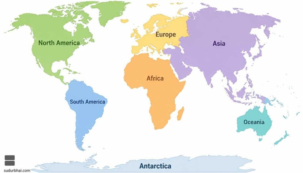
The Earth is divided into seven continents, namely:
- Asia
- Africa
- North America
- South America
- Europe
- Australia (Oceania)
- Antarctica
Facts about Asia
Geographical Extent
- Latitudinal Extent: 10°S to 80°N
- Longitudinal Extent: 25°E to 170°W
Area
- Total area is approximately 44.58 million sq. km, accounting for nearly 30% of the Earth’s land area, making Asia the largest continent.
Population
- Asia is home to over 4.8 billion people (latest estimate), representing nearly 60% of the world’s population, making it the most populous continent.
Major Oceans and Seas
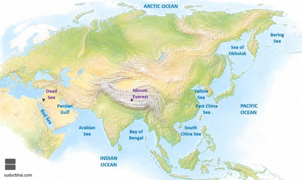
Asia is bounded by several important water bodies, including:
- Arctic Ocean
- Pacific Ocean
- Indian Ocean
- Red Sea
- Persian Gulf
- Gulf of Oman
- Arabian Sea
- Bay of Bengal
- South China Sea
- East China Sea
- Yellow Sea
- Sea of Okhotsk
- Bering Sea
Highest and Lowest Points
- Highest Point: Mount Everest (8,848.86 m) on the Nepal–China border.
- Lowest Land Point: Dead Sea Depression (about 430 m below mean sea level) between Jordan and Israel.
Important Lakes
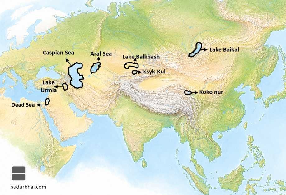
Some of Asia’s significant lakes are:
- Caspian Sea (world’s largest inland water body)
- Aral Sea
- Lake Baikal (world’s deepest freshwater lake)
- Lake Balkhash
- Issyk-Kul
- Dead Sea
Major Islands
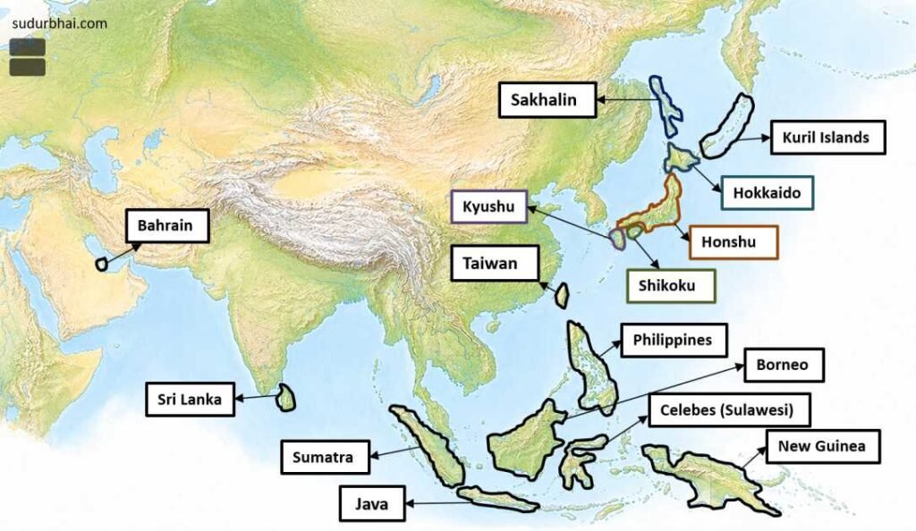
Prominent islands of Asia include:
- Kuril Islands
- Sakhalin
- Honshu
- Hokkaido
- Taiwan
- Borneo
- Java
- Sumatra
- Celebes (Sulawesi)
- New Guinea
- Philippines
- Sri Lanka
- Bahrain
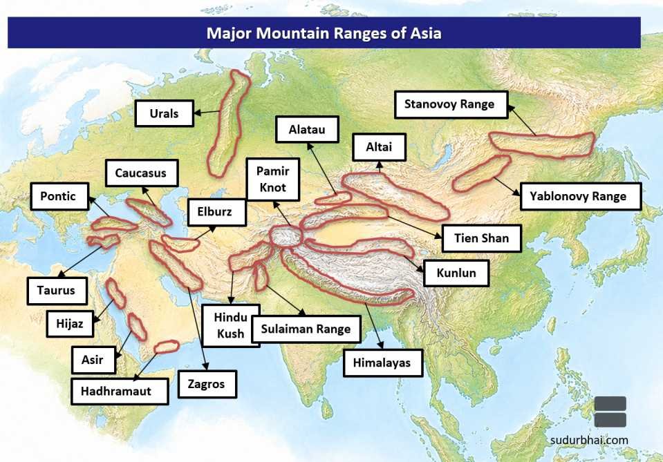
Major Mountain Ranges
Asia possesses the world’s highest and most extensive mountain systems, including:
- Pamir Knot
- Himalayas
- Karakoram
- Kunlun
- Tien Shan
- Altai
- Hindu Kush
- Elburz (Alborz)
- Pontic Mountains
- Sulaiman Range
- Zagros Mountains
- Taurus Mountains
- Ural Mountains
- Yablonovy Range
- Stanovoy Range
Major Plateaus
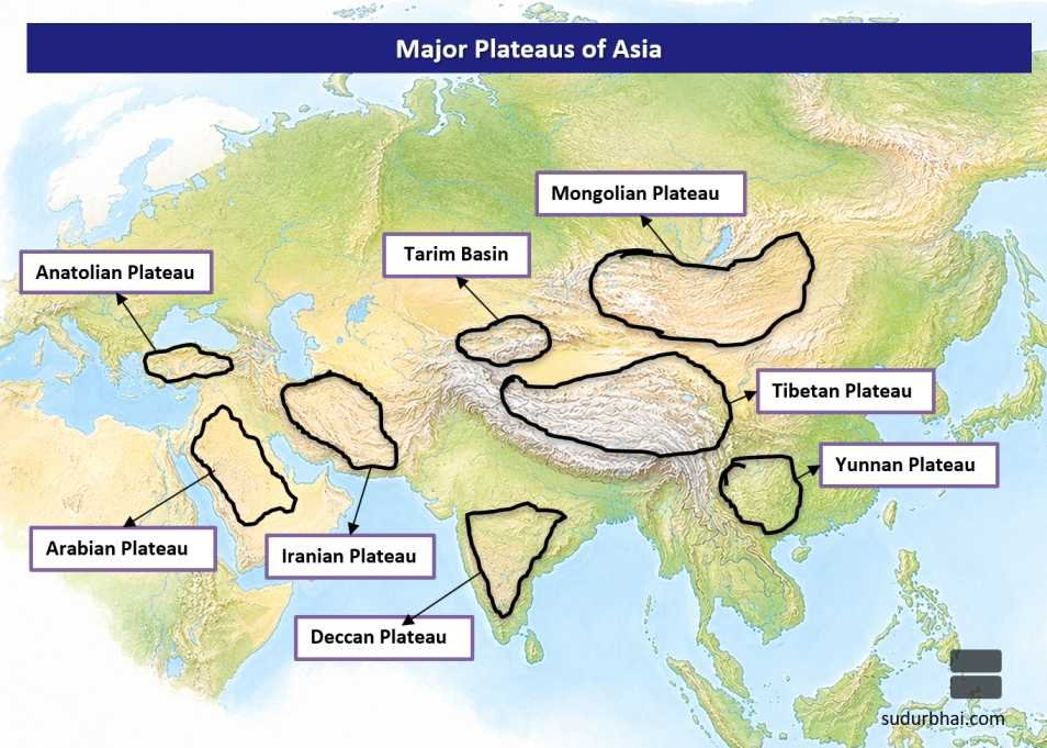
Important plateaus found in Asia are:
- Anatolian Plateau
- Iranian Plateau
- Arabian Plateau
- Tibetan Plateau (Highest Plateau of the World)
- Tarim Basin
- Mongolian Plateau
- Yunnan Plateau
- Deccan Plateau
Major Peninsulas
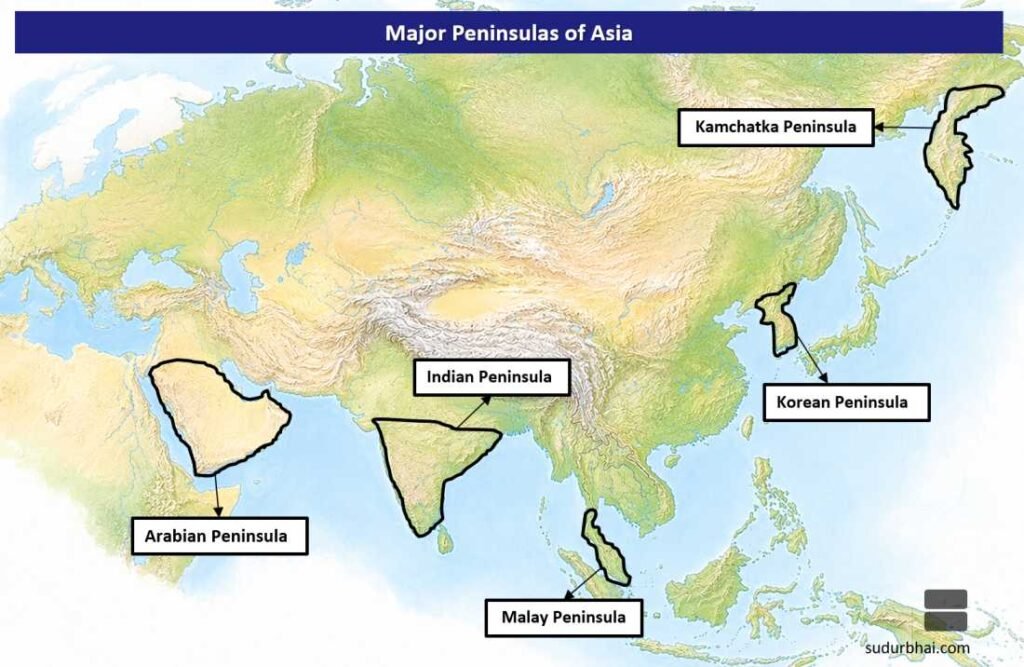
The principal peninsulas of Asia include:
- Kamchatka Peninsula
- Korean Peninsula
- Malay Peninsula
- Indian Peninsula
- Arabian Peninsula
Major Deserts
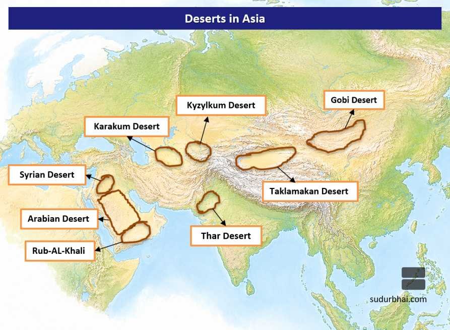
Asia contains several extensive deserts, such as:
- Arabian Desert
- Thar Desert
- Gobi Desert
- Taklamakan Desert
- Karakum Desert
- Kyzylkum Desert
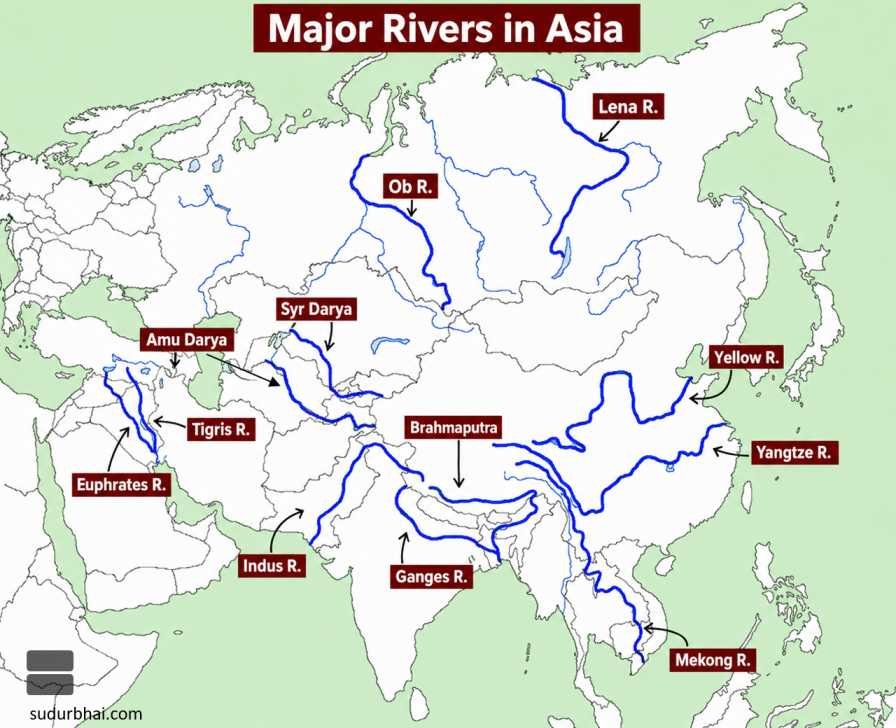
Major Rivers
Some of the longest and most important rivers of Asia are:
- Euphrates
- Tigris
- Indus
- Ganga
- Brahmaputra
- Yangtze (Chang Jiang)
- Yellow River (Huang He)
- Mekong
- Irrawaddy
- Salween
- Amur
- Lena
- Ob
- Yenisey
- Syr Darya
- Amu Darya
Important Cities
Major metropolitan centres of Asia include:
- New Delhi
- Mumbai
- Kolkata
- Dhaka
- Karachi
- Colombo
- Yangon
- Kathmandu
- Bangkok
- Kuala Lumpur
- Singapore
- Jakarta
- Manila
- Ho Chi Minh City
- Hong Kong
- Shanghai
- Beijing
- Tokyo
- Seoul
- Dubai
- Tehran
- Riyadh
Facts about Africa
Geographical Location
- Africa is the second-largest and second-most populous continent after Asia.
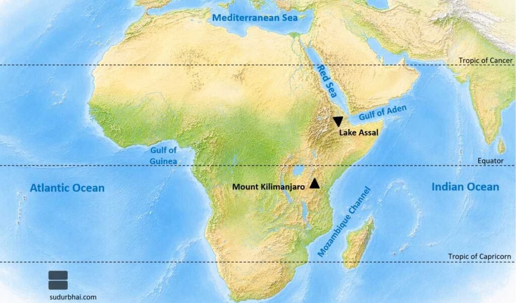
- It is the only continent through which the Equator, the Prime Meridian, and the Tropic of Cancer & Tropic of Capricorn all pass.
Latitudinal and Longitudinal Extent
- Latitudinal Extent: 35° South to 37° North
- Longitudinal Extent: 17° West to 51° East
Area
- Africa covers approximately 30.37 million sq. km, accounting for nearly 20% of the Earth’s land area.
Population
- The continent has a population of over 1.5 billion, contributing roughly 18% of the global population.
Major Oceans and Seas
Africa is surrounded by the following major water bodies:
- Atlantic Ocean
- Indian Ocean
- Mediterranean Sea
- Red Sea
- Gulf of Guinea
- Mozambique Channel
Highest and Lowest Points
- Highest Peak: Mount Kilimanjaro (5,895 m), Tanzania.
- Lowest Point: Lake Assal (approximately −155 m), Djibouti
Important Straits
Major strategic straits include:
- Bab-el-Mandeb Strait
- Strait of Gibraltar
- Mozambique Channel
Major Lakes
Important freshwater lakes are:
- Lake Victoria (Largest lake in Africa)
- Lake Tanganyika
- Lake Malawi (Nyasa)
- Lake Chad
- Lake Turkana (formerly Lake Rudolf)
- Lake Albert

Important Islands
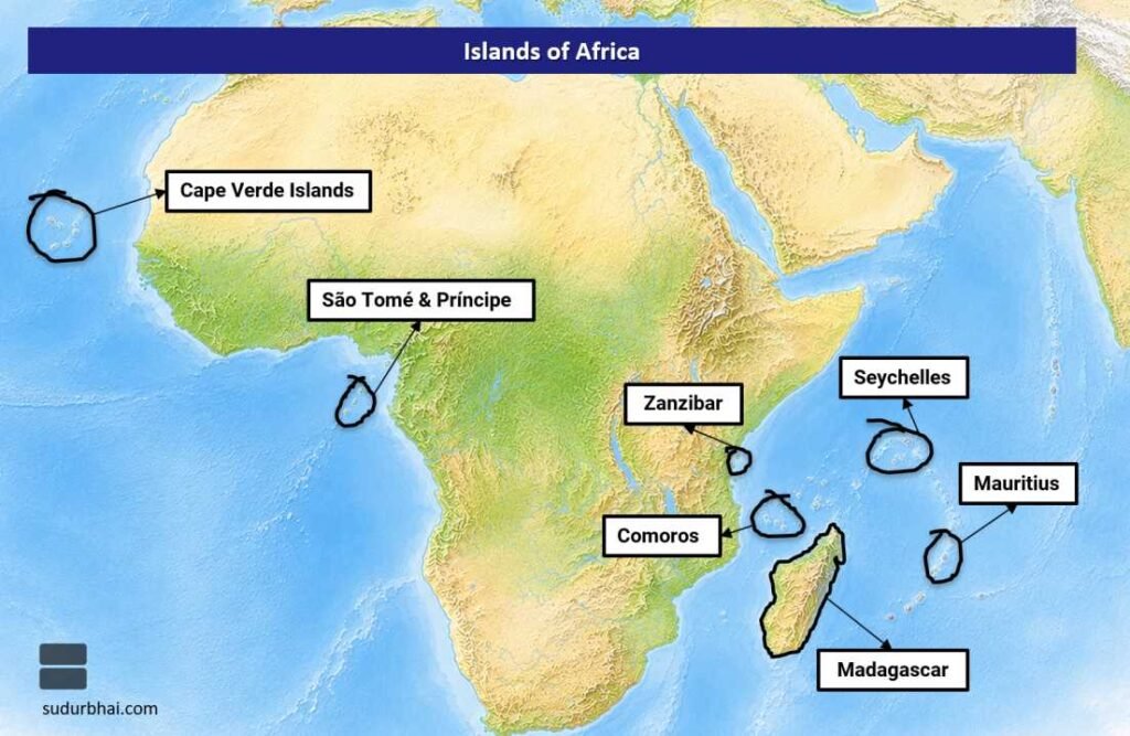
Major islands associated with Africa include:
- Madagascar
- Cape Verde Islands
- Comoros
- Mauritius
- Seychelles
- São Tomé & Príncipe
- Zanzibar
Major Mountain Ranges
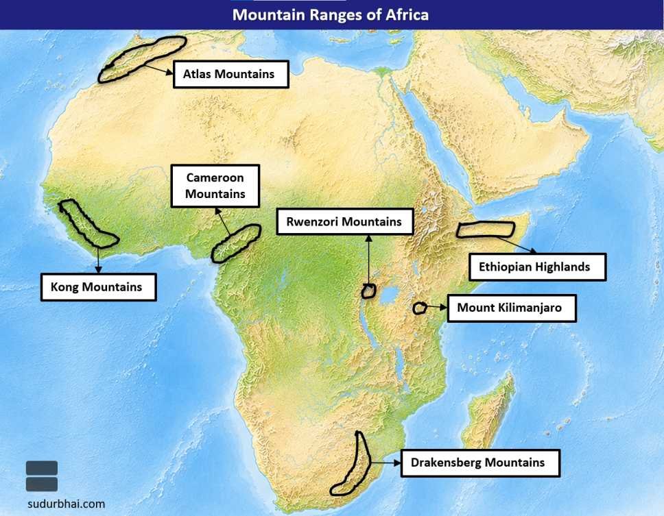
Important mountain systems include:
- Atlas Mountains
- Drakensberg Mountains
- Mount Kilimanjaro
- Rwenzori Mountains
- Ethiopian Highlands
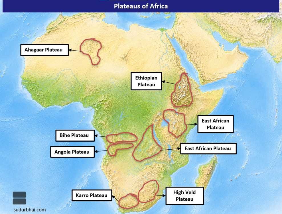
Major Plateaus
Africa is popularly known as the “Plateau Continent” because a large part of its surface consists of elevated plateaus.
Important plateaus include:
- East African Plateau
- South African Plateau
- Ethiopian Plateau
- Katanga Plateau
Major Deserts
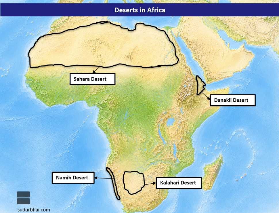
The principal deserts of Africa are:
- Sahara Desert (Largest hot desert in the world)
- Kalahari Desert
- Namib Desert
- Danakil Desert
Facts about North America
Geographical Location
- North America is the third-largest continent and lies almost entirely in the Northern Hemisphere.
- It includes Canada, the United States, Mexico, Central America, and the Caribbean Islands.
Latitudinal and Longitudinal Extent
- Latitudinal Extent: 7° North to 84° North
- Longitudinal Extent: 20° West to 180° West
Area
- North America occupies approximately 24.71 million sq. km, representing about 16.5% of the Earth’s land area.
Population
- The continent has a population of nearly 600 million, accounting for roughly 7–8% of the world’s population.
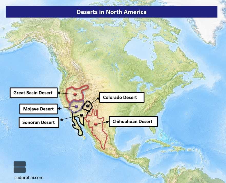
Major Deserts
The important deserts are:
- Chihuahuan Desert
- Colorado Desert
- Mojave Desert
- Sonoran Desert
- Great Basin Desert
Major Lakes
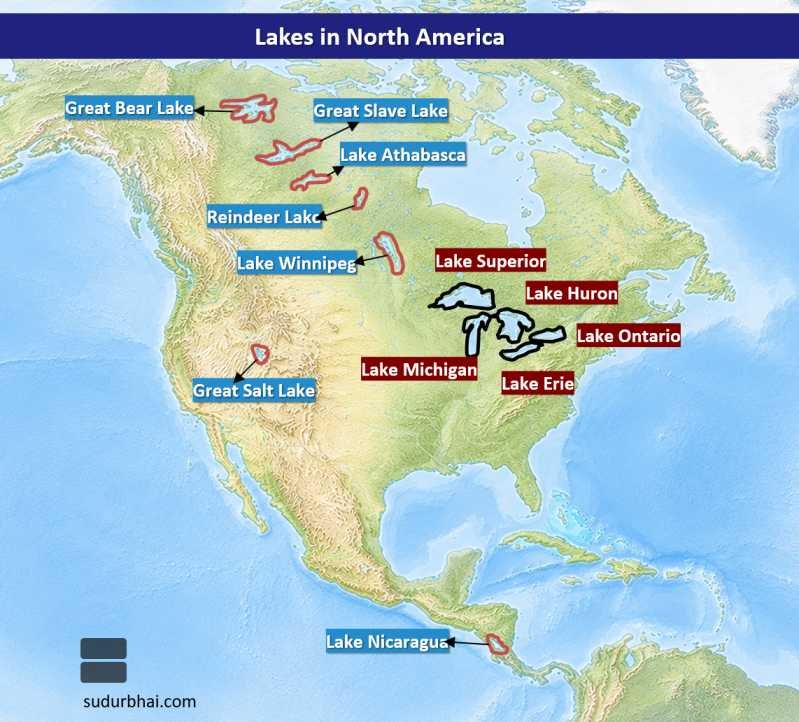
North America possesses the famous Great Lakes System, consisting of:
- Lake Superior (Largest freshwater lake by surface area)
- Lake Michigan
- Lake Huron
- Lake Erie
- Lake Ontario
Other important lakes include:
- Great Bear Lake
- Great Slave Lake
- Lake Athabasca
- Reindeer Lake
- Lake Winnipeg
- Great Salt Lake
- Lake Nicaragua
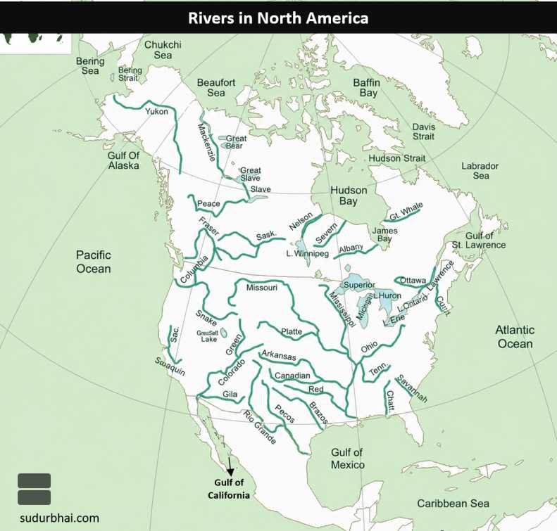
Major Rivers
Important river systems include:
- Mississippi River
- Missouri River
- St. Lawrence River
- Mackenzie River
- Colorado River
- Columbia River
- Rio Grande
- Yukon River
- Hudson River
- Ohio River
Major Oceans and Seas
North America is bordered by:
- Atlantic Ocean
- Pacific Ocean
- Arctic Ocean
- Caribbean Sea
- Gulf of Mexico
- Gulf of Alaska
- Bering Sea
- Hudson Bay
Coastline
- Canada has the world’s longest national coastline, extending over 243,000 km.
Highest and Lowest Points
- Highest Peak: Denali (Mount McKinley) – 6,190 m, Alaska.
- Lowest Point: Death Valley – about 86 m below sea level, California.
Important Strait
- Bering Strait, separating Asia and North America.
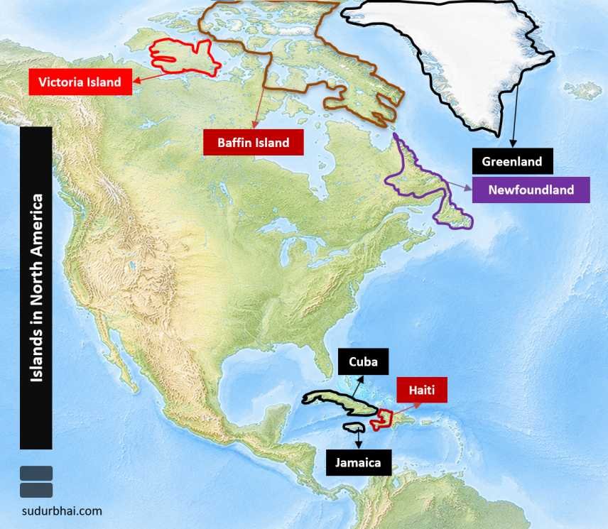
Major Islands
Important islands include:
- Greenland (World’s largest island)
- Baffin Island
- Victoria Island
- Newfoundland
- Cuba
- Jamaica
- Haiti (Hispaniola)
- Ellesmere Island
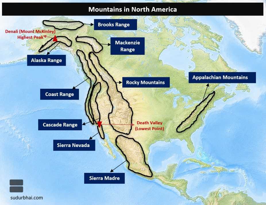
Major Mountain Ranges
Significant mountain systems are:
- Rocky Mountains
- Appalachian Mountains
- Brooks Range
- Alaska Range
- Cascade Range
- Coast Mountains
- Sierra Nevada
- Sierra Madre
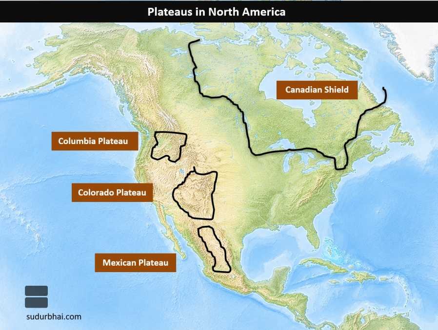
Major Plateaus
Major plateaus include:
- Colorado Plateau
- Columbia Plateau
- Mexican Plateau
- Canadian Shield (Ancient Precambrian Plateau)
Agriculture
Major agricultural products include:
- Wheat
- Maize
- Soybean
- Cotton
- Sugar Beet
- Potato
- Fruits
- Temperate Cash Crops
Major Mineral Resources
North America is rich in:
- Coal
- Petroleum
- Natural Gas
- Iron Ore
- Copper
- Nickel
- Uranium
- Gold
- Manganese
Major Industries
Important industries include:
- Automobile Manufacturing
- Aerospace
- Shipbuilding
- Information Technology
- Petrochemicals
- Steel
- Electronics
- Food Processing
Important Cities
Major urban centres include:
- New York
- Washington D.C.
- Boston
- Chicago
- Dallas
- Detroit
- San Francisco
- Los Angeles
- Seattle
- Toronto
- Montreal
- Vancouver
- Mexico City
- Havana
- Kingston
- Ottawa
Climate
North America exhibits remarkable climatic diversity due to its extensive latitudinal range, altitude, and relief features.
The continent experiences:
- Tropical Rainforest Climate
- Savanna Climate
- Humid Subtropical Climate
- Mediterranean Climate
- Temperate Continental Climate
- Steppe Climate
- Desert Climate
- Sub-Arctic Climate
- Tundra Climate
- Polar Climate
Facts about Latin America & the Caribbean
Geographical Location
- Latin America comprises South America, Central America, Mexico, and the Caribbean Islands.
- It extends from the Tropics to the Southern Hemisphere, making it one of the most geographically diverse regions in the world.
Latitudinal and Longitudinal Extent
- Latitudinal Extent: 12° North to 55° South
- Longitudinal Extent: 35° West to 81° West
Area
- Covers approximately 17.8 million sq. km, representing nearly 12% of the Earth’s land area.
Population
- The region has a population of around 660 million, accounting for roughly 8% of the global population.
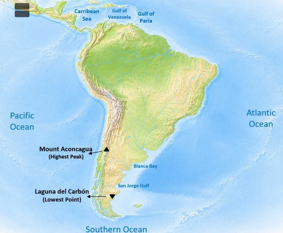
Major Oceans and Seas
Latin America is bordered by:
- Atlantic Ocean
- Pacific Ocean
- Caribbean Sea
- Gulf of Venezuela
- Gulf of Paria
- Blanca Bay
- San Jorge Gulf
Highest and Lowest Points
- Highest Peak: Aconcagua (6,961 m), Argentina.
- Lowest Point: Laguna del Carbón (−105 m), Argentina.
Important Strait
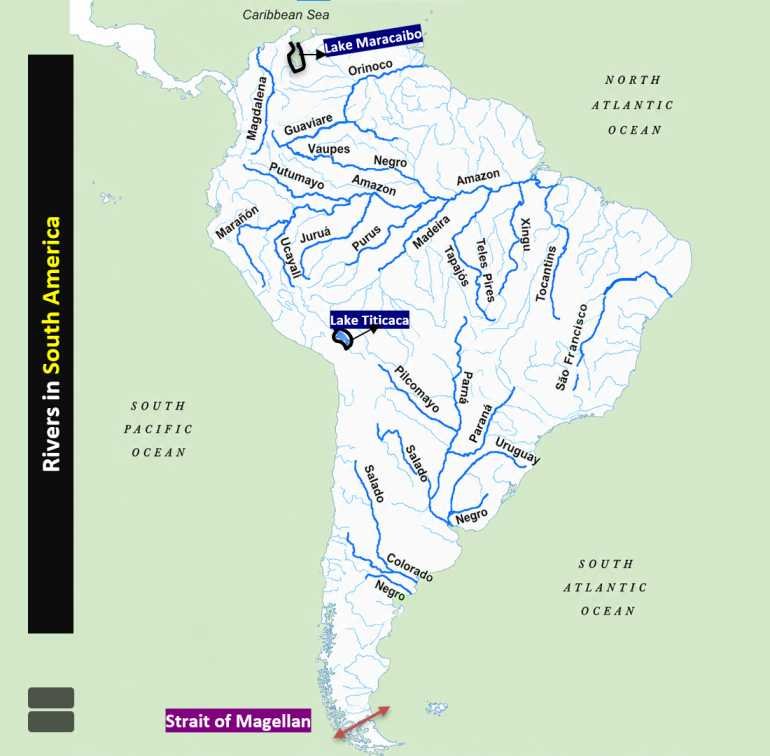
- Strait of Magellan, connecting the Atlantic Ocean and the Pacific Ocean.
Major Lakes
Important lakes include:
- Lake Maracaibo
- Lake Titicaca (Highest navigable lake in the world)
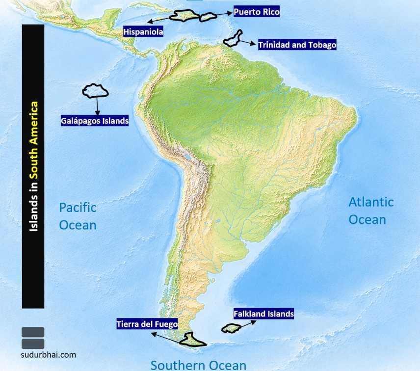
Major Islands
Prominent islands include:
- Galápagos Islands
- Falkland Islands (Islas Malvinas)
- Tierra del Fuego
- Hispaniola
- Puerto Rico
- Trinidad
Major Mountain Ranges
The principal mountain system is:
- Andes Mountains (Longest continental mountain range in the world)
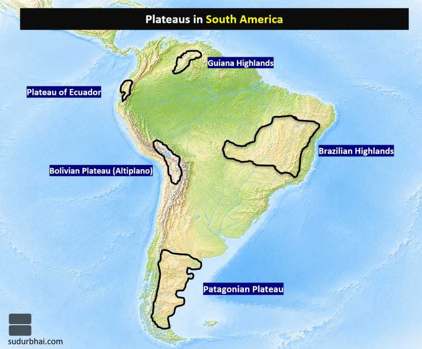
Major Plateaus
Important plateaus include:
- Bolivian Plateau (Altiplano)
- Plateau of Ecuador
- Brazilian Highlands
- Patagonian Plateau
- Guiana Highlands
Major Deserts
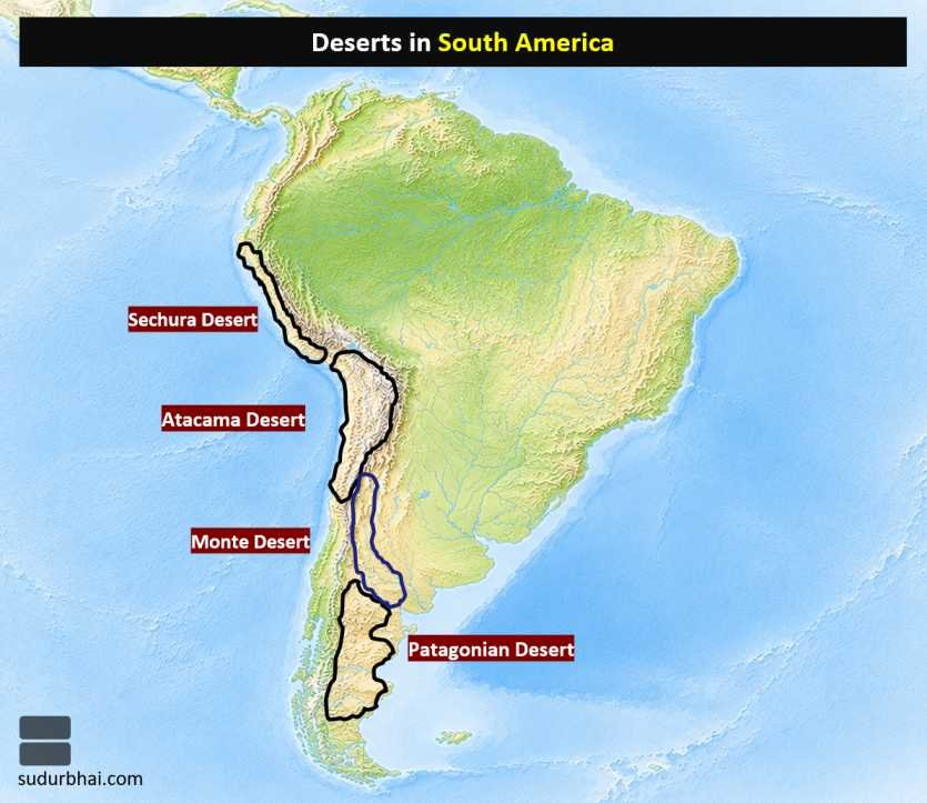
Significant deserts include:
- Atacama Desert (Driest non-polar desert in the world)
- Patagonian Desert
- Sechura Desert
- Monte Desert
Major Rivers
The region is drained by several major river systems, including:
- Amazon River (Largest river by discharge)
- Orinoco River
- Paraná River
- Paraguay River
- Uruguay River
- São Francisco River
Important Cities
Major urban centres include:
- Buenos Aires
- Rio de Janeiro
- São Paulo
- Brasília
- Lima
- Bogotá
- Santiago
- Quito
- Caracas
- Montevideo
- La Paz
- Belém
- Manaus
- Mexico City
- Havana
Facts about Europe
Geographical Location
- Europe is the second-smallest continent, located entirely in the Northern Hemisphere and largely within the Eastern Hemisphere.
- It is often regarded as part of the larger Eurasian landmass.
Latitudinal and Longitudinal Extent
- Latitudinal Extent: 35° North to 73° North
- Longitudinal Extent: 25° West to 65° East
Area
- Europe occupies approximately 10.53 million sq. km, accounting for nearly 7% of the Earth’s land area.
Population
- The continent has a population of around 740 million, contributing about 9–10% of the world’s population.
Major Oceans and Seas
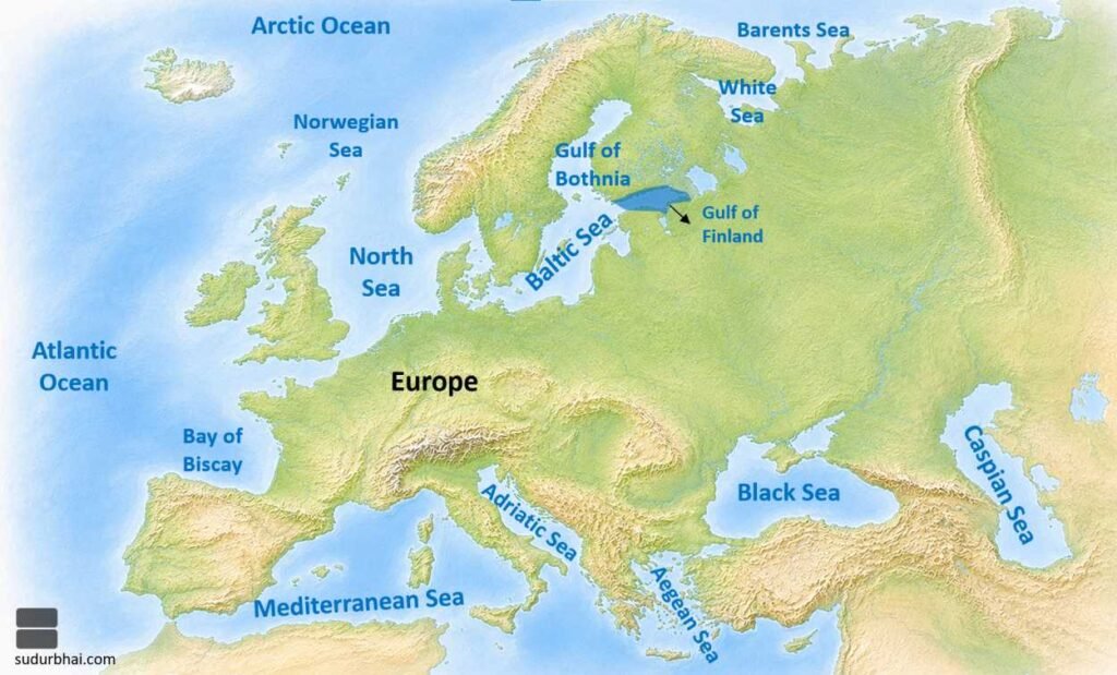
Europe is surrounded by numerous important water bodies:
- Atlantic Ocean
- Arctic Ocean
- Mediterranean Sea
- North Sea
- Baltic Sea
- Black Sea
- White Sea
- Norwegian Sea
- Barents Sea
- Caspian Sea
- Adriatic Sea
- Aegean Sea
- Bay of Biscay
- Gulf of Bothnia
- Gulf of Finland
Highest and Lowest Points
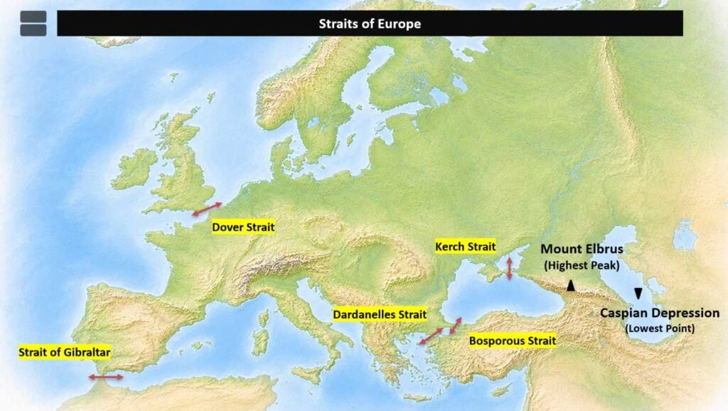
- Highest Peak: Mount Elbrus (5,642 m), Russia.
- Lowest Point: Caspian Depression (about −28 m).
Important Strait
- Strait of Gibraltar, separating Europe from Africa.
- Dover Strait
- Kerch Strait
- Bosporous Strait
- Dardanelles Strait
Major Lakes
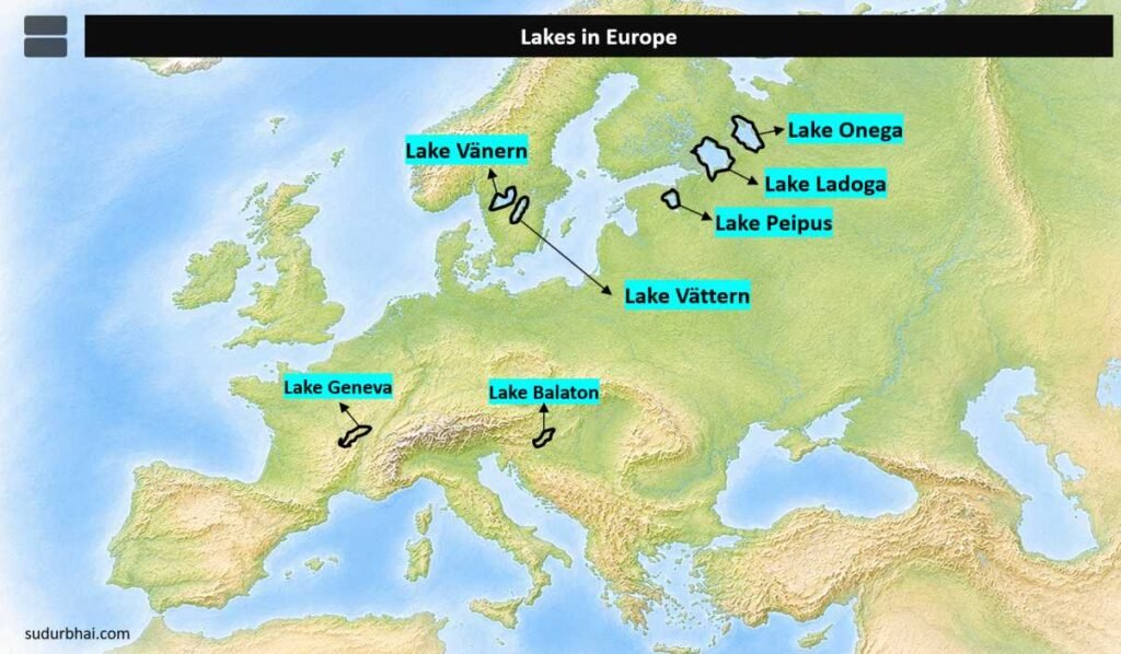
Important lakes include:
- Lake Ladoga (Largest lake in Europe)
- Lake Onega
- Lake Peipus
- Lake Vänern
- Lake Vättern
- Lake Geneva
- Lake Balaton
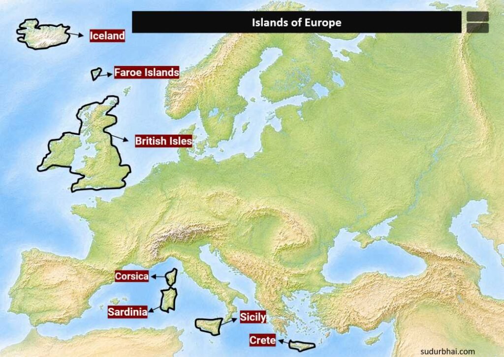
Major Islands
Prominent islands include:
- British Isles
- Iceland
- Sicily
- Sardinia
- Crete
- Corsica
- Faroe Islands
Major Mountain Ranges
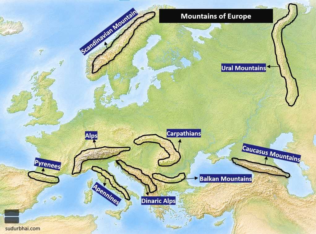
Europe’s major mountain systems include:
- Alps
- Pyrenees
- Apennines
- Carpathians
- Dinaric Alps
- Balkan Mountains
- Caucasus Mountains
- Ural Mountains
- Scandinavian Mountains
Major Plateaus
Important plateaus include:
- Bohemian Plateau
- Spanish Meseta (Central Plateau)
- Central Massif (France)
- Scottish Highlands
Major Rivers
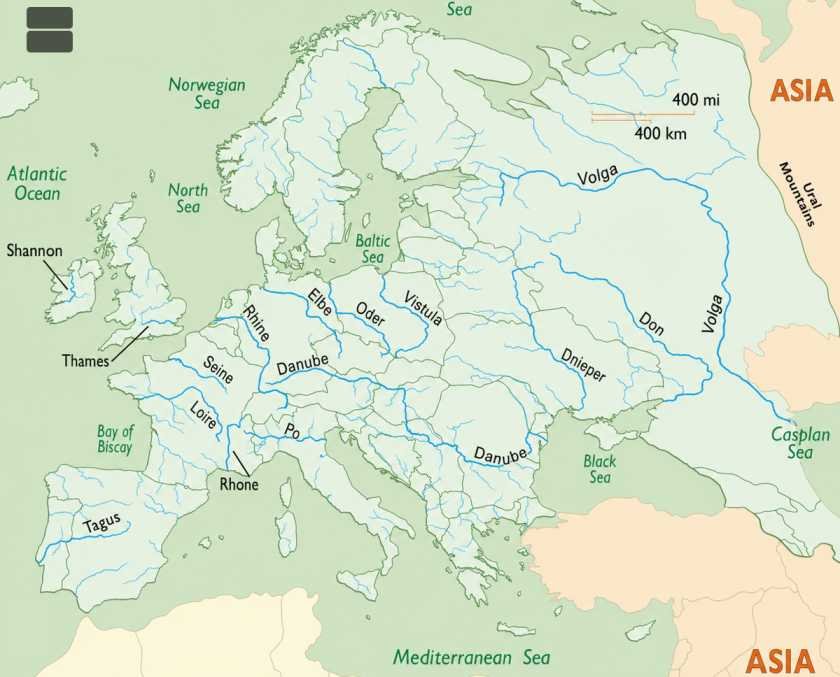
Europe possesses several navigable rivers, including:
- Volga (Longest river in Europe)
- Danube
- Rhine
- Po
- Dnieper
- Don
- Vistula
- Elbe
- Oder
- Seine
- Loire
- Tagus
- Douro
- Thames
- Ural River
Important Cities
Major metropolitan centres include:
- London
- Paris
- Madrid
- Berlin
- Rome
- Moscow
- Amsterdam
- Brussels
- Vienna
- Prague
- Budapest
- Warsaw
- Athens
- Copenhagen
- Oslo
- Stockholm
- Helsinki
- Dublin
- Lisbon
- Munich
- Belgrade
- Frankfurt
- Venice
Climate
Europe experiences a predominantly temperate climate, although considerable regional variation exists due to latitude, oceanic influence, and relief.
Major climatic regions include:
- Marine West Coast Climate
- Mediterranean Climate
- Humid Continental Climate
- Sub-Arctic Climate
- Tundra Climate
- Highland Climate
Facts about Australia
Geographical Location
- Australia is the smallest continent and the largest island in the world.
- Together with New Zealand and the islands of the Pacific Ocean, it forms the geographical region known as Oceania.
- The broader cultural-geographical region comprising Australia, New Zealand, New Guinea, Melanesia, Micronesia, and Polynesia is often referred to as Australasia.
Latitudinal and Longitudinal Extent
- Latitudinal Extent: 12° South to 38° South
- Longitudinal Extent: 114° East to 154° East
Area
- Australia covers approximately 7.69 million sq. km, accounting for nearly 5% of the Earth’s land area.
Population
- Australia (Oceania region) has a population of over 46 million, while Australia alone has a population exceeding 27 million (latest estimates).
Major Oceans and Seas
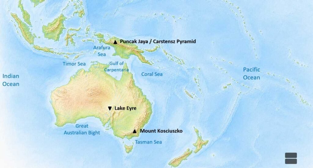
Australia is surrounded by several important water bodies, including:
- Indian Ocean
- Pacific Ocean
- Tasman Sea
- Coral Sea
- Arafura Sea
- Timor Sea
- Gulf of Carpentaria
- Great Australian Bight
Highest and Lowest Points
- Highest Peak (Australia Mainland): Mount Kosciuszko (2,228 m)
- Highest Peak (Oceania): Puncak Jaya / Carstensz Pyramid (4,884 m), New Guinea
- Lowest Point: Lake Eyre (Kati Thanda) – approximately 15 m below sea level
Important Strait
- Bass Strait, separating Tasmania from mainland Australia.
Major Lakes
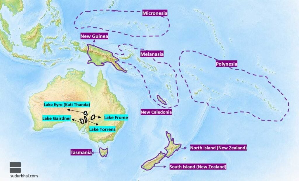
Important lakes include:
- Lake Eyre (Kati Thanda)
- Lake Torrens
- Lake Gairdner
- Lake Frome
Major Islands
Significant islands include:
- Tasmania
- New Guinea
- North Island (New Zealand)
- South Island (New Zealand)
- New Caledonia
Major Mountain Ranges
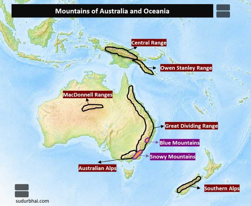
The principal mountain systems are:
- Great Dividing Range
- Australian Alps
- Blue Mountains
- Snowy Mountains
- MacDonnell Ranges
Major Plateaus
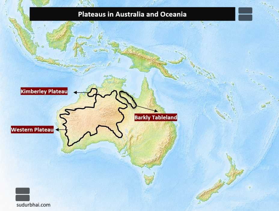
Australia is largely a plateau continent. Important plateaus include:
- Western Plateau
- Kimberley Plateau
- Barkly Tableland
Major Deserts
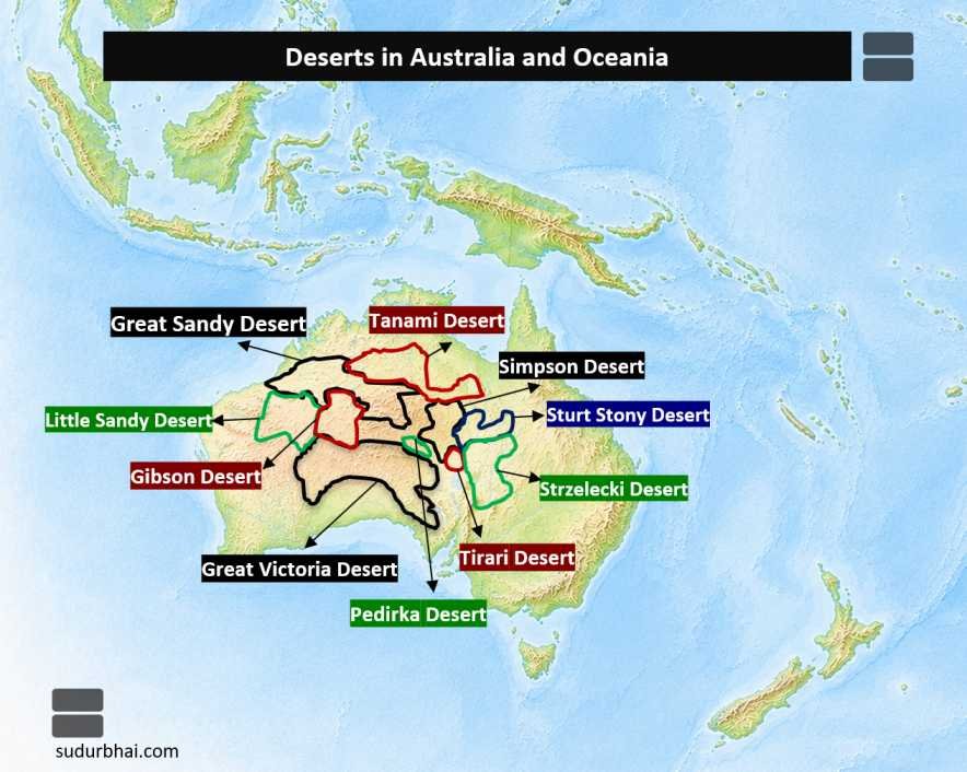
Australia contains several extensive deserts, including:
- Great Victoria Desert
- Great Sandy Desert
- Gibson Desert
- Simpson Desert
- Tanami Desert
- Little Sandy Desert
Important Rivers
Major river systems include:
- Murray River
- Darling River
- Murrumbidgee River
- Cooper Creek
- Lachlan River
Important Cities
Major cities of Australia include:
- Canberra (Capital City)
- Sydney
- Melbourne
- Brisbane
- Perth
- Adelaide
- Hobart
- Darwin
- Gold Coast
Climate
Australia experiences a wide variety of climatic conditions because of its latitudinal extent, oceanic influence, and relief.
Major climatic regions include:
- Tropical Monsoon Climate (Northern Australia)
- Tropical Savanna Climate
- Hot Desert Climate
- Semi-Arid (Steppe) Climate
- Mediterranean Climate (South-western & Southern Australia)
- Humid Subtropical Climate (Eastern Coast)
- Temperate Oceanic Climate (Tasmania & South-east Highlands)
- Alpine Climate (Australian Alps)