
Geographical Location of Assam
Latitudinal Extent of Assam
Assam lies between 24°08′ N to 28°02′ N latitudes
Entirely located in sub-tropical zone
Close proximity to the Tropic of Cancer (23½° N) influences:
- High summer temperatures
- Strong monsoonal rainfall
- Dense vegetation cover
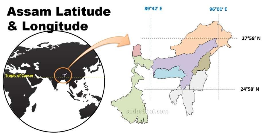
Longitudinal Extent of Assam
Extends from 89°42′ E to 96°02′ E longitudes
Lies in the eastern part of India
Experiences early sunrise compared to western India. [one of the important reason for the demand of adoption of Tea Garden Time (Cha Bagan Time)]
Areal Extent of Assam
Total geographical area: 78,438 sq km
Ranks 14th among Indian states by area
Accounts for about 2.4% of India’s total geographical area
- Among North-East Indian States;
- Area wise, Assam = 2nd Largest state of N-E India
[Area of NE states (decreasing order) : Arunachal Pradesh > Assam > Meghalaya > Manipur > Mizoram > Nagaland > Tripura] - Population wise , Assam = Largest State of N-E India.
[Population of NE states (decreasing order) : Assam > Tripura > Meghalaya > Manipur > Nagaland > Arunachal Pradesh > Mizoram > Sikkim]
- Area wise, Assam = 2nd Largest state of N-E India
Physiographic Setting of Assam
Assam is located in the central part of North-East India
Forms the core of the Brahmaputra Valley
Acts as a transitional zone between:
Indian Peninsular Plateau
Eastern Himalayan Mountain System
Indo-Myanmar ranges
Assam’s Location in Relation to Major Physical Features
Himalayan Influence
Northern Assam influenced by:
Eastern Himalayas
Heavy orographic rainfall
Flash floods
Indo-Myanmar Ranges
Eastern and southern boundaries defined by:
Patkai Hills
Naga Hills
Lushai Hills
Act as:
Climatic barrier
Cultural divide
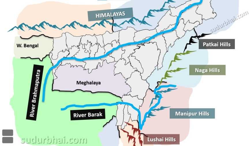
River Systems and Boundaries
Brahmaputra Valley dominates central Assam
Barak Valley lies in southern Assam
Rivers act as:
Natural boundaries
Communication routes
Flood hazards
Today is my first view on your page and honestly it is very helpful 🙏❤️
Thank u …great content
One of the best INITIATIVE that you are doing,, it’s mind blowing and very very important for competitive exams, if possible then create practice MCQ,, otherwise it’s also helpful.