District Overview: Tinsukia
- Location: Northeastern part of Assam, India.
- Established: October 1, 1989.
- Headquarters: Tinsukia town.
- Significance: Known for its cultural heritage, agriculture, and industry.
Tinsukia District – Key Points
Early History
Part of the Chutiya Kingdom during the medieval period.
After the Ahoms defeated the Chutiyas, they appointed the Sadiya-Khowa Gohain as the governor.
The Matak Kingdom emerged after the Moamoria Rebellion.
King Sarbananda Singha, of Chutiya descent, established his capital at Rangagarh on the Guijan River.
In 1791 AD, the capital moved to Bengmara (modern-day Tinsukia), built with the help of Minister Gopinath Barbaruah (Godha).
Captain Hamilton Vetch’s 1841 map referred to much of present-day Dibrugarh and Tinsukia as the “Bengmara Country of the Moamareeya Tribe”.
Development
King Sarbananda Singha commissioned the Tinikunia Pukhuri (triangular pond), from which Tinsukia derives its name.
Several tanks were dug during his reign, including Chauldhuwa Pukhuri, Kadamoni Pukhuri, Na-Pukhuri, Devi Pukhuri, and Rupahi Pukhuri.
Roads like Godha-Borbaruah Road, Rangagarah Road, Rajgor Road, and Hatiali Road were developed in the Matak Kingdom.
The British discovered tea plants in Sadiya (1823), leading to the first tea plantation in Chabua near Tinsukia.
The Dibru–Sadiya Railway (1882), established by the Assam Railway & Trading Company, accelerated economic growth.
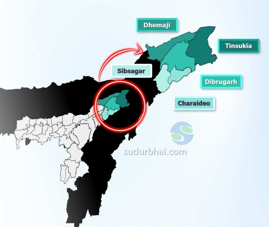
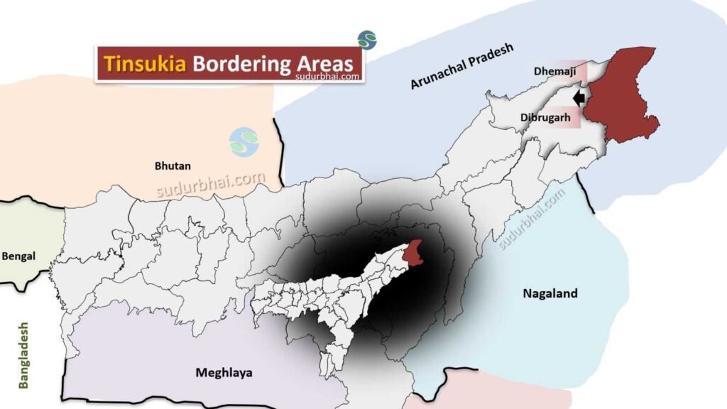
Tinsukia became Assam’s 23rd district on October 1, 1989, after being split from Dibrugarh.
Geography of Tinsukia
- Area: About 3,790 square kilometers.
- Coordinates: From 27°14′ N to 27°48′ N latitude and 95°13′ E to 96°00′ E longitude.
- Boundaries:
- North: Bordered by Dibrugarh district.
- South: Borders the Brahmaputra River.
- East: Adjacent to Changlang district in Arunachal Pradesh.
- West: Bordered by Dibrugarh and Sivasagar districts.
- Topography: Mix of flat plains and hilly terrain, with fertile land for agriculture.
- Rivers: Major rivers include the Brahmaputra, Dibru, and Burhi Dihing.
- Climate: Humid subtropical climate with hot summers and mild winters. Annual rainfall averages 2,323 mm (mostly during the monsoon from June to September).
Socio-Economy of Tinsukia
- Agriculture: Main economic activity. Key crops include rice, tea, oranges, ginger, and citrus fruits. Famous for its tea plantations.
- Livestock: Common activities include cattle, goat, and poultry farming.
- Industry: Tinsukia is home to Digboi, the oldest oil refinery in India. It also has significant coal mining in Margherita and Ledo and a Hindustan Unilever (HUL) cosmetic plant.
- Trade and Commerce: A commercial hub due to its strategic location and industrial activities.
Transport in Tinsukia
- Roadways: Well-connected by National Highway 15 and other roads.
- Railways: The Tinsukia Railway Station is an important junction on the Northeast Frontier Railway network.
- Airways: The nearest airport is in Dibrugarh, around 40 km away, linking Tinsukia to major cities in India.
Demographics of Tinsukia
- Population
- Total Population: 1,327,929
- Male: 680,231
- Female: 647,698
- Tinsukia District population constituted 4.26 percent of total Maharashtra population
- Population Growth: 15.47% (2001-2011)
- Average Literacy Rate: 69.66%
- Male Literacy Rate: 77.19%
- Female Literacy Rate: 61.73%
- Sex Ratio: 952 females per 1000 males
- Child Sex Ratio (0-6 years): 960 girls per 1000 boys
- Total Child Population: 181,826
- Percentage of District Population: 13.69%
- Rural Population: 1,063,186
- Percentage of Total Population: 80.06%
- Urban Population: 264,743
- Percentage of Total Population: 19.94%
- Rural Literacy: 65.05%
- Urban Literacy: 87.22%
- Population: 126,389
- Literacy Rate: 89.03%
- Sex Ratio: 875 females per 1000 males
- Child Population (0-6 age): 12,576
- Population
Administrative Setup of Tinsukia
- District Headquarters: Tinsukia town.
- Sub-Divisions: Tinsukia Sadar, Sadiya, Margherita, and Doomdooma.
- Revenue Circles: Includes Tinsukia Circle and Sadiya Circle.
- Development Blocks: Several development blocks focused on local governance and development.
Rainfall in Tinsukia
- Average Annual Rainfall: Ranges from 2,300 mm to 3,000 mm, with heavy rain during the monsoon season.
- Impact: Rain enhances soil fertility for agriculture, but can also lead to flooding.
Attractive Tourist Places in Tinsukia
Historical Sites
Na-Pukhuri: A group of nine ponds from the Muttock Kingdom, built during King Sarbananda Singha’s reign (1788–1805).
The central pond (11.75 acres) has potential for development into a lake and amusement area.
The surrounding park has been renovated and renamed “Marut Nandan Kanan”.
Ruins of the Ancient Ahom Kingdom: Remnants of structures reflecting the region’s historical significance.
Other Attractions
Dibru-Saikhowa National Park: A biodiversity hotspot with a unique mix of flora and fauna, with potential to become a tiger reserve.
Stilwell Road (Ledo Road): Built during World War II, this historic road starts in Ledo, Tinsukia, and extends to Kunming, China.
Digboi (27 km from Tinsukia):
Home to India’s first oil refinery and oil field.
Features the National Oil Park and Museum.
Ridge Hill viewpoint offers a panoramic view of the oil fields.
Margherita (45 km from Tinsukia): Known for lush tea gardens and scenic beauty.
Tilinga Mandir: A revered temple where devotees tie bells as a symbol of fulfilled wishes.
Languages Spoken in Tinsukia
- Assamese: 47.8%
- Sadan/Sadri: 14.1%
- Bengali: 10.05%
- Hindi: 8.54%
- Nepali: 7.52%
- Bhojpuri: 2.30%
- Odia: 2.11%
- Miri/Mishing: 1.46%
Let us know any further suggestions ,we at sudurbhai.com will be happy to hear from you in our comment section below !