
Earthquake
- An Earthquake is the sudden shaking or vibration of the Earth’s surface caused by the rapid release of stored energy within the Earth’s crust.
- Earthquake results from the release of accumulated tectonic stress (caused by the movement of Lithospheric Plates along geological faults), volcanic activity, or often human-induced causes.
- This energy travels in the form of Seismic Waves, producing ground motion that may result in the destruction of life and property.
- The scientific study of earthquakes is known as Seismology, and the scientist who studies earthquakes is called a Seismologist.
Parts of an Earthquake
Focus (Hypocentre)
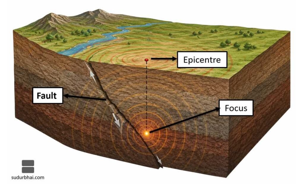
- The Focus is the point inside the Earth where the earthquake originates.
- It is the location where rocks first break and release energy.
Epicentre
- The Epicentre is the point on the Earth’s surface directly above the Focus.
- It usually experiences the maximum intensity of shaking.
Fault
- A Fault is a fracture or crack in the Earth’s crust along which rocks move during an earthquake.
Causes of Earthquakes
Tectonic Earthquakes
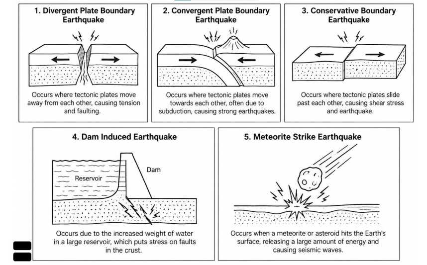
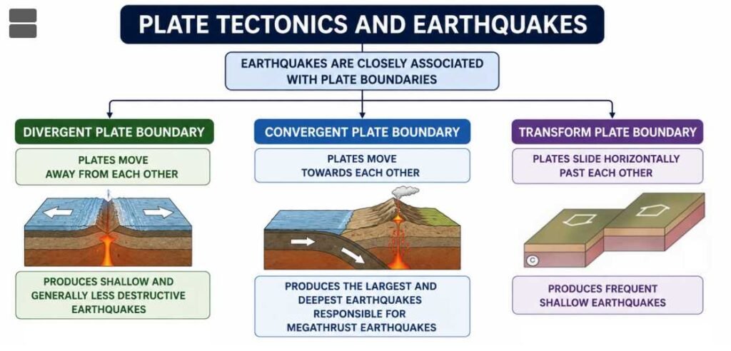
- Caused by the movement of Lithospheric Plates.
- Account for nearly 90–95% of all earthquakes.
- Most common along Plate Boundaries.
Volcanic Earthquakes
- Occur due to the movement of Magma beneath active volcanoes.
- Generally confined to volcanic regions.
Collapse Earthquakes
- Caused by the collapse of underground caves, mines or caverns.
- Usually small in magnitude.
Reservoir-Induced Earthquakes
- Triggered by the construction of large dams and reservoirs.
- The enormous weight of stored water increases pressure on underlying rocks.
Human-induced Earthquakes
Artificial activities that may generate earthquakes include:
- Mining
- Nuclear Explosions
- Deep Drilling
- Hydraulic Fracturing (Fracking)
- Large-scale Blasting
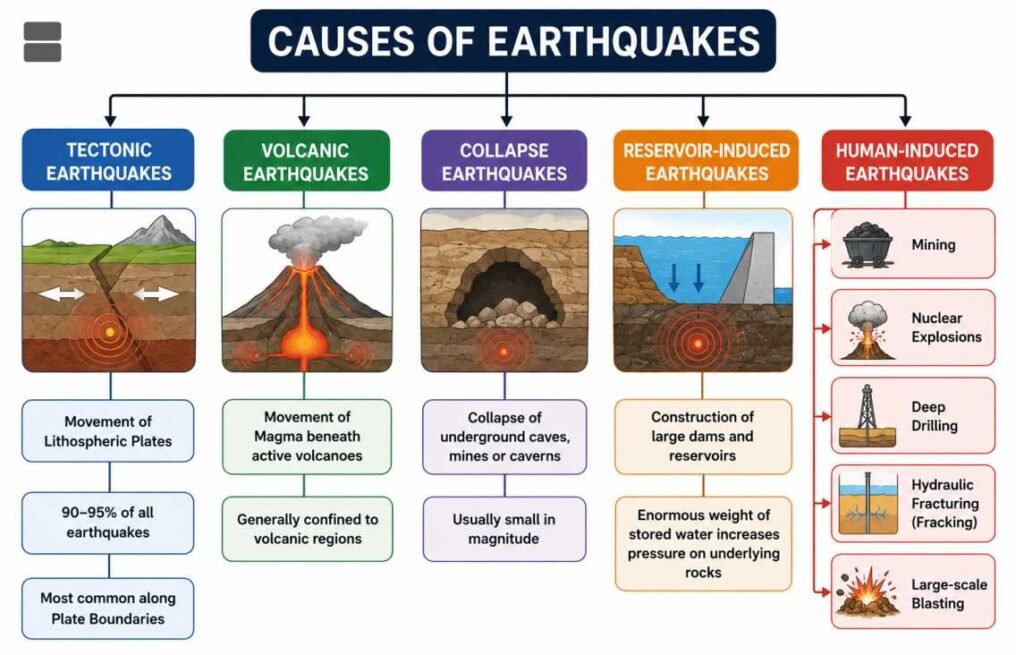
Plate Tectonics and Earthquakes
Earthquakes are closely associated with Plate Boundaries.
Divergent Plate Boundary
- Plates move away from each other.
- Produces shallow and generally less destructive earthquakes.
Example
- Mid-Atlantic Ridge
Convergent Plate Boundary
- Plates move towards each other.
- Produces the largest and deepest earthquakes.
- Responsible for Megathrust Earthquakes.
Examples
- Himalayas
- Japan
- Chile
Transform Plate Boundary
- Plates slide horizontally past each other.
- Produces frequent shallow earthquakes.
Example
- San Andreas Fault (California)
Seismic Waves
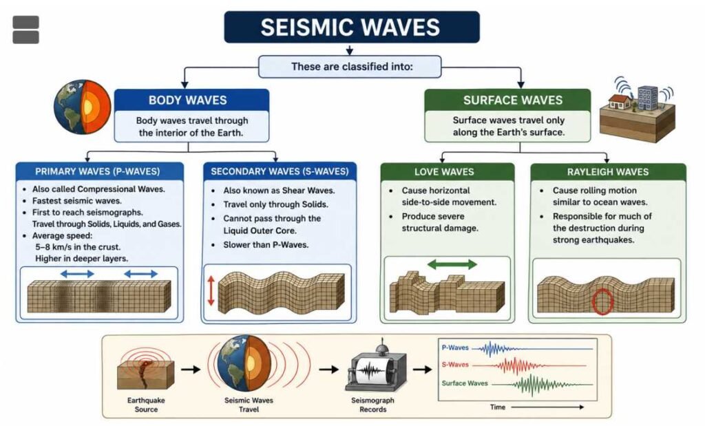
When an earthquake occurs, energy is released in the form of Seismic Waves.
These are classified into:
- Body Waves
- Surface Waves
Body Waves
Body waves travel through the interior of the Earth.
Primary Waves (P-Waves)
- Also called Compressional Waves.
- Fastest seismic waves.
- First to reach seismographs.
- Travel through Solids, Liquids, and Gases.
- Average speed:
- 5–8 km/s in the crust.
- Higher in deeper layers.
Secondary Waves (S-Waves)
- Also known as Shear Waves.
- Travel only through Solids.
- Cannot pass through the Liquid Outer Core.
- Slower than P-Waves.
Surface Waves
Surface waves travel only along the Earth’s surface.
Love Waves
- Cause horizontal side-to-side movement.
- Produce severe structural damage.
Rayleigh Waves
- Cause rolling motion similar to ocean waves.
- Responsible for much of the destruction during strong earthquakes.
Comparison of Seismic Waves
| Feature | P-Waves | S-Waves | Surface Waves |
|---|---|---|---|
| Type | Body Wave | Body Wave | Surface Wave |
| Speed | Fastest | Slower | Slowest |
| Medium | Solids, Liquids & Gases | Solids only | Earth’s Surface |
| Motion | Compressional | Shear | Rolling & Horizontal |
| Damage | Least | Moderate | Maximum |
Measurement of Earthquakes
Magnitude of Earthquakes
- Magnitude measures the total energy released during an earthquake.
Measured by:
- Moment Magnitude Scale (Mw) (Modern Standard)
- Richter Scale (Older Scale)
Characteristics
- Magnitude is expressed on a logarithmic scale.
- Increase of 1 magnitude represents:
- 10 times greater wave amplitude
- About 32 times more energy released.
Intensity of Earthquakes
- Intensity measures the actual effects and damage caused at a particular location.
Measured by:
- Modified Mercalli Intensity (MMI) Scale
Ranges from:
- I (Not Felt) to
- XII (Total Destruction)
Seismograph
- A Seismograph is an instrument used to detect, record, and measure seismic waves.
Seismogram
- The graphical record produced by a seismograph is known as a Seismogram.
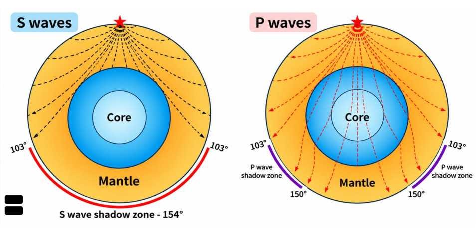
Shadow Zones
P-Wave Shadow Zone
- Extends from approximately 103° to 142° from the epicentre.
- Caused by the refraction of P-Waves at the Outer Core.
S-Wave Shadow Zone
- Extends beyond 103° from the epicentre.
- Exists because S-Waves cannot travel through the Liquid Outer Core.
These shadow zones provide strong evidence that the Outer Core is liquid.

Distribution of Earthquakes
Most earthquakes occur along major Plate Boundaries.
The three major earthquake belts are:
Circum-Pacific Belt
- Also called the Ring of Fire.
- Accounts for nearly 80% of global earthquakes.
Countries include:
- Japan
- Indonesia
- Philippines
- Chile
- Peru
- USA (West Coast)
Mediterranean–Himalayan Belt
- Accounts for approximately 15% of earthquakes.
Extends through:
- Southern Europe
- Turkey
- Iran
- Afghanistan
- Pakistan
- India
- Nepal
- Myanmar
Mid-Oceanic Ridge Belt
- Earthquakes occur along Divergent Plate Boundaries.
- Generally shallow and less destructive.
Earthquake Zones of India
India is divided into four seismic zones.
| Zone | Risk Level |
|---|---|
| Zone II | Low Risk |
| Zone III | Moderate Risk |
| Zone IV | High Risk |
| Zone V | Very High Risk |
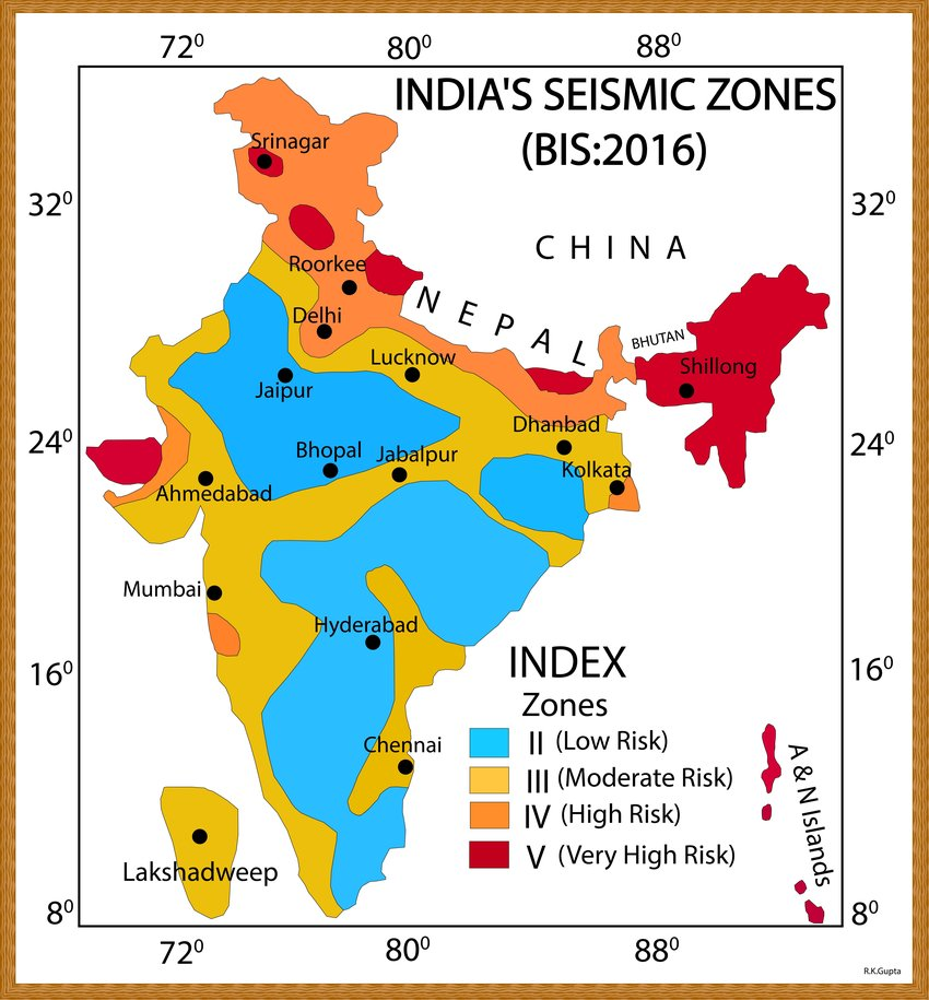
Zone V
Includes:
- Entire North-East India
- Kashmir
- Parts of Himachal Pradesh
- Uttarakhand
- North Bihar
- Rann of Kachchh
- Andaman & Nicobar Islands
Zone IV
Includes:
- Delhi
- Chandigarh
- Northern Punjab
- Parts of Haryana
- Western Uttar Pradesh
- Northern West Bengal
Effects of Earthquakes
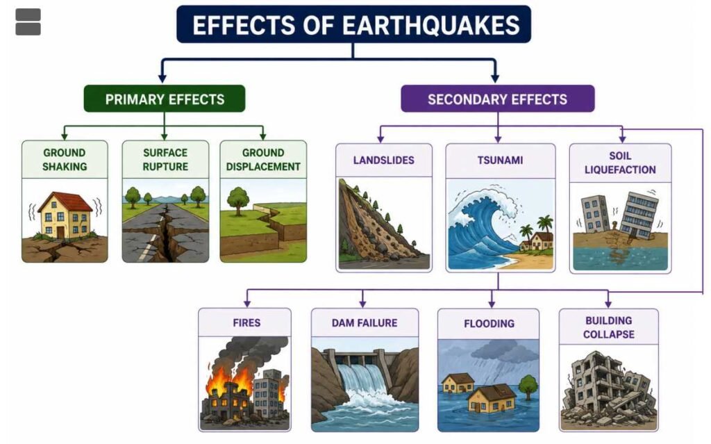
Primary Effects
- Ground shaking
- Surface rupture
- Ground displacement
Secondary Effects
- Landslides
- Tsunami
- Soil Liquefaction
- Fires
- Dam Failure
- Flooding
- Building Collapse
Earthquake Prediction
Although earthquakes cannot yet be predicted accurately, scientists monitor:
- Seismic activity
- GPS measurements
- Ground deformation
- Radon gas emission
- Satellite observations
These methods help in earthquake forecasting and hazard assessment, but not precise prediction.
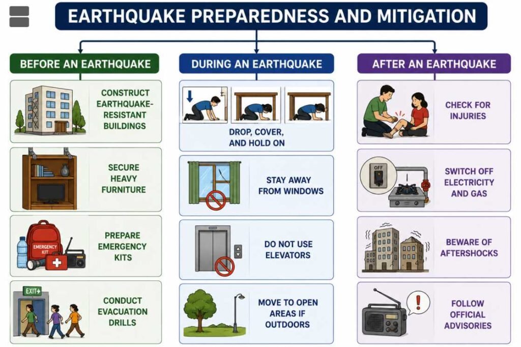
Earthquake Preparedness and Mitigation
Before an Earthquake
- Construct earthquake-resistant buildings.
- Secure heavy furniture.
- Prepare emergency kits.
- Conduct evacuation drills.
During an Earthquake
- Drop, Cover, and Hold On.
- Stay away from windows.
- Do not use elevators.
- Move to open areas if outdoors.
After an Earthquake
- Check for injuries.
- Switch off electricity and gas.
- Beware of aftershocks.
- Follow official advisories.
Important Earthquake-related Terms
| Term | Meaning |
|---|---|
| Focus (Hypocentre) | Origin of earthquake inside Earth |
| Epicentre | Point directly above the Focus |
| Fault | Fracture along which rocks move |
| Foreshock | Small earthquake before the main shock |
| Mainshock | Largest earthquake in a sequence |
| Aftershock | Smaller earthquakes occurring after the mainshock |
| Liquefaction | Water-saturated soil behaves like a liquid during shaking |
| Seismograph | Instrument that records earthquakes |
| Seismogram | Record produced by a seismograph |
Major Earthquakes in the World
| Year | Location | Magnitude (Mw) |
|---|---|---|
| 1960 | Valdivia, Chile | 9.5 (Largest Recorded) |
| 1964 | Alaska, USA | 9.2 |
| 2004 | Sumatra–Andaman | 9.1–9.3 |
| 2011 | Tōhoku, Japan | 9.1 |
| 1952 | Kamchatka, Russia | 9.0 |
Major Earthquakes in India
| Year | Location | Magnitude |
|---|---|---|
| 1897 | Shillong | 8.1 |
| 1905 | Kangra | 7.8 |
| 1934 | Bihar–Nepal | 8.1 |
| 1950 | Assam–Tibet | 8.6 |
| 1993 | Latur | 6.2 |
| 2001 | Bhuj (Gujarat) | 7.7 |
| 2005 | Kashmir | 7.6 |
| 2011 | Sikkim | 6.9 |