West Karbi Anglong District
INDEX
1. District Overview
2. History of West Karbi Anglong District
3. Geography of West Karbi Anglong District
4. Socio-Economy of West Karbi Anglong District
5. Transport in West Karbi Anglong District
6. Demographics of West Karbi Anglong District
7. Administrative Setup of West Karbi Anglong District
8. Tourist Places in West Karbi Anglong District
9. Languages Spoken in West Karbi Anglong District
District Overview of West Karbi Anglong District
- Location: In Assam, India, formed on February 9, 2016, from Karbi Anglong district.
- Headquarters: Hamren.
- Significance: Part of the Karbi Anglong Autonomous Council, governed by the Sixth Schedule of the Indian Constitution.

History of West Karbi Anglong District
Early History & Formation
- The Karbi people, a Tibeto-Burman group, migrated from western China and settled near the Kalang and Kopili rivers before moving into the hills due to Dimasa Kachari rule.
- They later lived under Jaintia suzerainty in the Jaintia Hills.
- Hill tribes of the region, including present-day Karbi Anglong, West Karbi Anglong, and Dima Hasao, remained independent until British colonization.
- As per the Government of India Act, 1935, the region was classified as a “Partially Excluded Area,” administered directly under the Governor’s special powers.
- Semsonsing Ingti and others demanded a separate administrative unit for Karbis, leading to the formation of Karbi-A-Dorbar in 1946.
Post-Independence & District Formation
- November 17, 1951: United Mikir & North Cachar Hills district was created under the Sixth Schedule of the Indian Constitution.
- February 2, 1970: The district was split into Karbi Anglong and North Cachar Hills districts.
- October 14, 1976: Mikir Hills district was renamed Karbi Anglong.
- 2016: Karbi Anglong was further divided, creating West Karbi Anglong, with Hamren as its headquarters.
Geography of West Karbi Anglong District
- Area: 3,035 square kilometers (1,171 square miles).
- Coordinates: Between 25°33′ N and 26°09′ N latitude and 92°08′ E and 93°04′ E longitude.
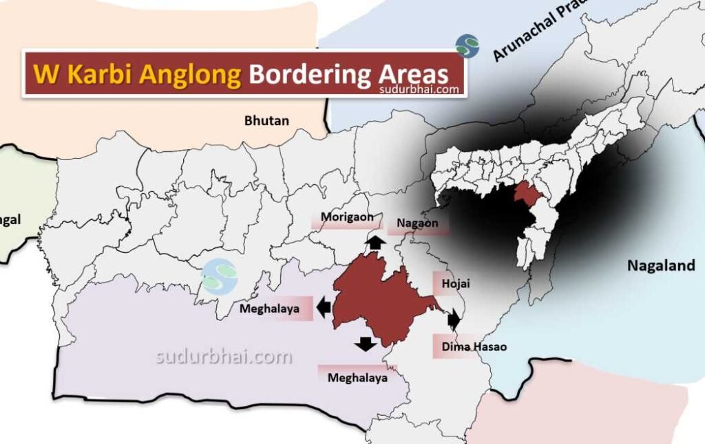
- Boundaries:
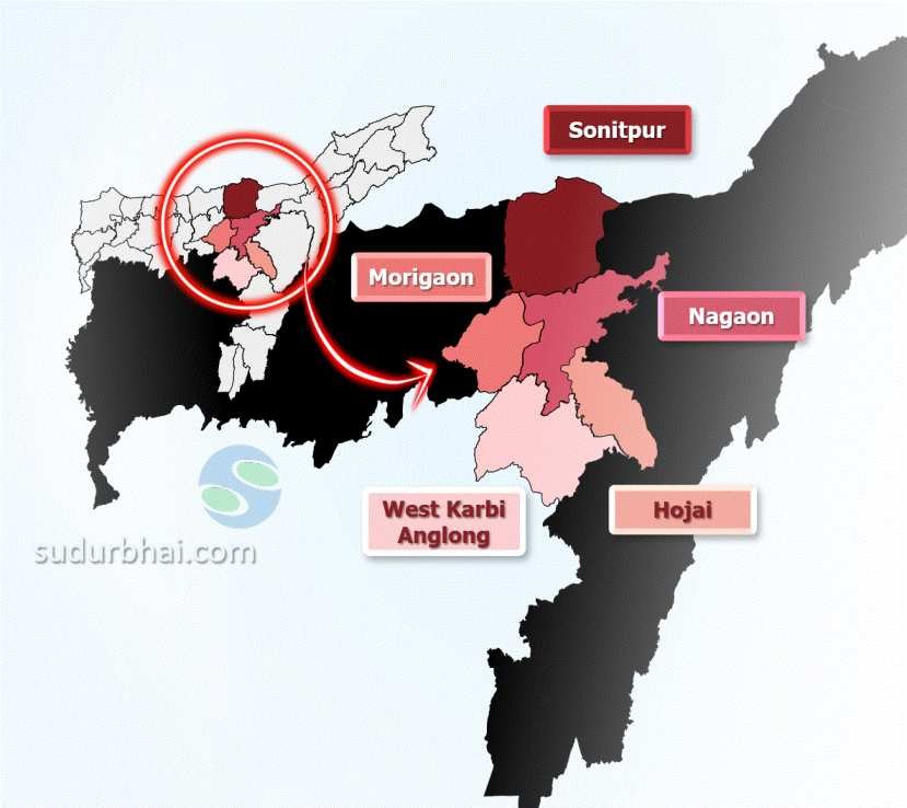
- North: Morigaon , Nagaon
- South: Meghalaya
- East: Hojai , Dima Hasao
- West: Meghalaya
West Karbi Anglong Neighbouring districts - Topography: The district is hilly, with valleys, plateaus, dense forests, and rivers.
- Rivers: Major rivers include Myntriang, Karbi Langpi, Kopili, and Amreng.
- Climate: Subtropical climate with mild winters and warm summers. Average annual rainfall: 2,416 mm (mostly from June to September).
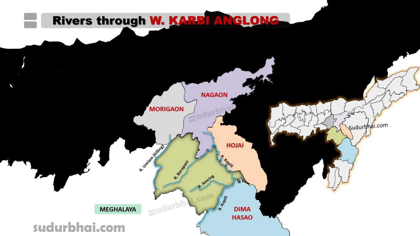
Socio-Economy of West Karbi Anglong District
- Agriculture: The district has ginger, sugarcane, maize, cotton, coconut, chilies, and black pepper as main crops. It is also known for its horticultural products.
- Livestock: Pig farming, poultry, and dairy farming are common.
- Small-scale Industries: Includes food processing, bamboo crafts, and potential for handicrafts and tourism.
- Challenges: Despite good agricultural productivity, the district faces limited infrastructure and market access.
Transport in West Karbi Anglong District
- Roadways: Well-connected by roads to major towns and cities in Assam, including state highways for easier travel.
- Railways: The nearest railway station is Hamren, around 10 km away.
- Airways: The nearest airport is in Dimapur, 90 km from Hamren.
Demographics of West Karbi Anglong District
- Population (2011 Census): Approximately 295,358.
- Sex Ratio: 954 females for every 1,000 males, indicating a slightly imbalanced gender ratio.
- Literacy Rate: 63.35%, with challenges in educational access in rural areas.
- Ethnic Composition: Mainly Karbis, Bodos, and other tribal groups.
Administrative Setup of West Karbi Anglong District
- District Headquarters: Hamren.
- Sub-Division: One sub-division – Hamren.
- Revenue Circles: Multiple revenue circles within the district.
- Development Blocks: The district has four development blocks:
- Amri
- Chinthong
- Rongkhang
- Socheng
Attractive Tourist Places in West Karbi Anglong District
- Karbi Anglong Hills: Known for scenic beauty and opportunities for trekking and eco-tourism.
- Kheroni Jiri Waterfall: A beautiful waterfall popular with nature lovers.
- Traditional Villages: Showcasing indigenous culture and crafts.
Umswai Valley:
- Part of the ancient Karbi-Meghalaya plateau, known for eco-tourism.
- Home to Hill Tiwa tribes, preserving their unique culture.
- Notable villages: Bormarjong, Amsai Pinung, Shikdamakha.
Nothengpi:
- Symbolic Karbi earring, culturally significant since pre-colonial times.
- Karbi Heritage Museum in Taralangso is designed after Nothengpi.
- Venue for the Karbi Youth Festival, showcasing Karbi culture.
Languages Spoken in West Karbi Anglong District
- Karbi : 49.68%
- Bhojpuri : 10.37%
- Nepali : 6.98%
- Bengali : 5.89%
- Garo : 5.73%
- Tiwa : 5.43%
- Assamese : 4.69%
- Khasi : 3.27%
- Hindi : 3.18%
- Dimasa : 1.45%
- Boro : 1.28%
Let us know any further suggestions ,we at sudurbhai.com will be happy to hear from you in our comment section below !