
Road Transport in Assam
- Road transport serves as the primary mode of connectivity in Assam, across its diverse terrain including plains, hills, and the plateau regions.
- It accounts for approximately 60% of the total road length in the Northeast region, making Assam a gateway for regional connectivity and economic integration.
Historical Development of Road Transport in Assam
- Colonial Era: Roads were initially developed for resource extraction like tea, coal, and timber, with limited focus on internal connectivity due to riverine challenges and flood-prone areas.
- Post-Independence:
Expansion under Five-Year Plans
Emphasis on border connectivity
Focus on rural road development
- Gradually, focus shifted to rural roads and national highways under schemes like PMGSY.
- Key milestones include the Saraighat Bridge (1962) as the first major crossing over the Brahmaputra.
- Modern Phase: Accelerated under SARDP-NE (Special Accelerated Road Development Programme for North East) since 2005, focusing on strategic connectivity and border infrastructure.
Current Status and Statistics of Road Transport in Assam
- Total Road Network: Approximately 59,261 km as of March 2022, comprising
- National Highways (3,883 km),
- State Highways (2,540 km),
- Major District Roads (4,310 km),
- Urban Roads (1,739 km), and
- Rural Roads (46,790 km).
- Road density = about 75.6 km per 100 sq km, higher than the national average but unevenly distributed.
- Assam officially operates three Inter-State Bus Terminals (ISBT) located in Guwahati, Jorhat and Silchar.
- Road Accidents: Highest in Northeast with 36,800 incidents from 2019-2023, leading to 15,163 fatalities; factors include over-speeding, poor maintenance, and traffic congestion.
- Total Road Network: Approximately 59,261 km as of March 2022, comprising
Key Infrastructure: Major Highways in Assam
- National Highways: Maintained by National Highways Authority of India. Key routes include ;
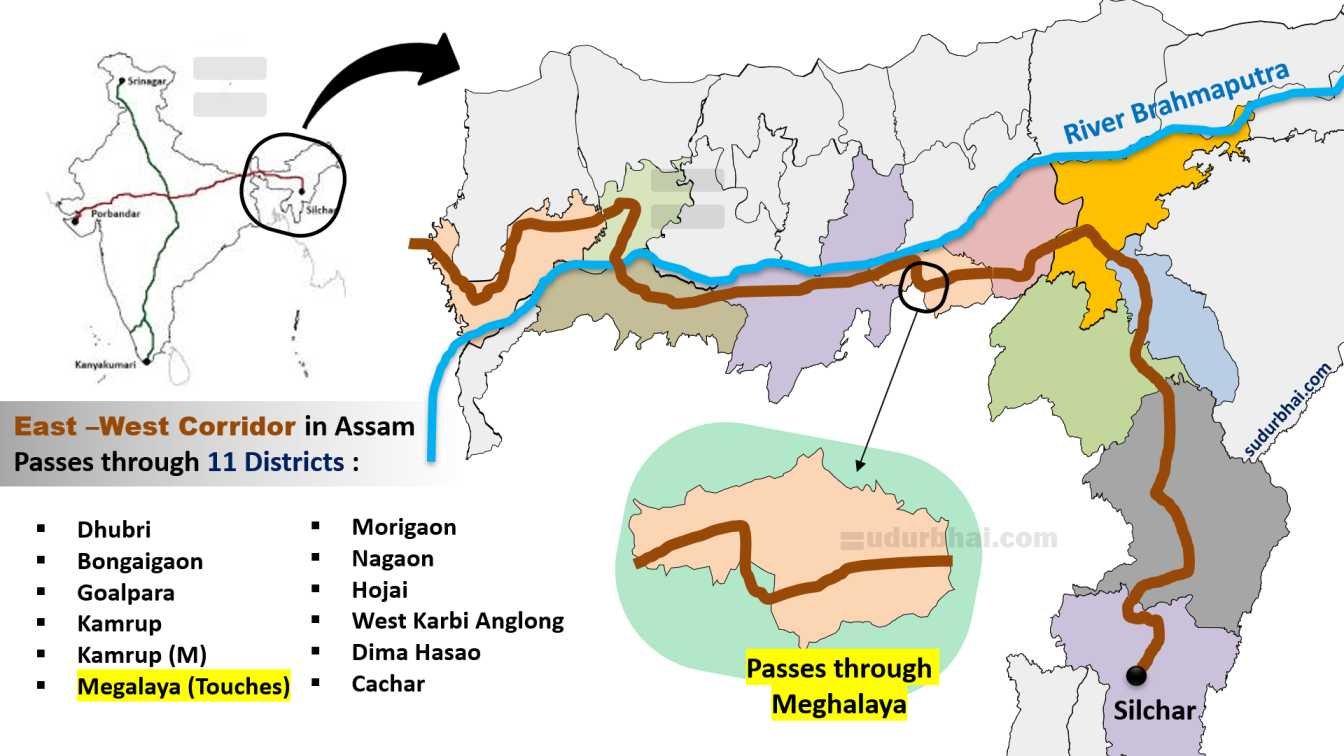
- NH-27 (East-West Corridor) connecting Silchar to Porbandar.
- NH-37 – Runs parallel to Brahmaputra River , connecting Upper and Lower Assam.
NH-17
NH-15
- State Highways:Maintained by Public Works Department (PWD), Assam and upgraded under Asom Mala program for four-laning and climate resilience.
- National Highways: Maintained by National Highways Authority of India. Key routes include ;
Key Infrastructure: Major Bridges over Brahmaputra
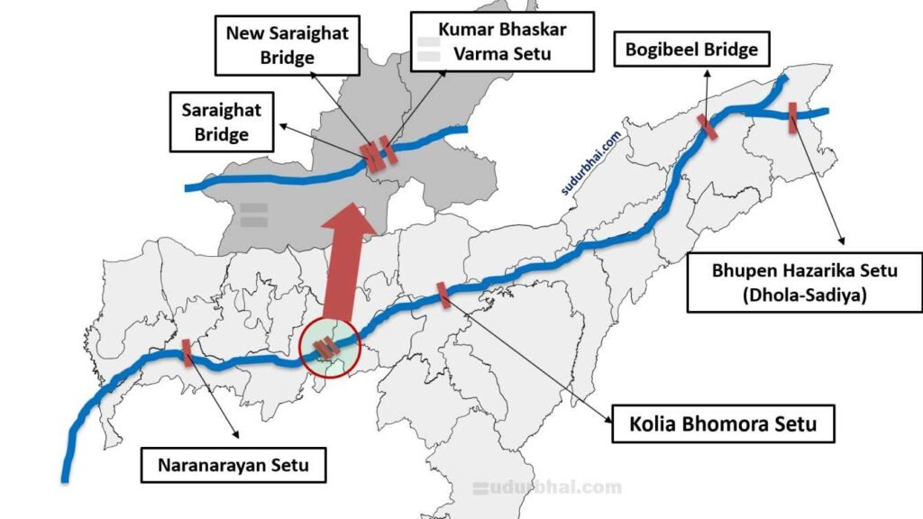
There are 7 bridges presently functional over river Brahmaputra :
- Saraighat Bridge (1962): 1.49 km rail-cum-road bridge near Guwahati, first permanent crossing; connects north and south banks.
- New Saraighat Bridge (2017): Parallel 1.5 km road bridge to ease congestion.
- Kolia Bhomora Setu (1987): 3.015 km near Tezpur, linking Nagaon and Sonitpur.
- Naranarayan Setu (1998): 2.3 km rail-cum-road at Jogighopa, vital for western Assam.
- Bogibeel Bridge (2018): 4.94 km, India’s longest rail-cum-road bridge between Dibrugarh and Dhemaji; earthquake-resistant.
- Bhupen Hazarika Setu (Dhola-Sadiya) (2017): 9.15 km, longest bridge in India over Lohit River, connecting Tinsukia districts; supports defense mobility.
- Kumar Bhaskar Varma Setu : 1.24 km road bridge connecting Guwahati and North Guwahati.
- Government Initiatives and Developments
- SARDP-NE and Bharat Mala: Upgrading NHs to multi-lane standards; Rs 80,000 crore investment for roads in Assam under Bharat Mala by 2029.
- Asom Mala Program: Improving 1,296 km of state highways and Major District Roads (MDRs); includes climate-resilient designs and road safety measures.
- ADB-Funded Projects: 312.5 km upgrades in western, central, and southern Assam for disaster resilience and asset management.
- Ongoing Bridges: New 4-lane bridge from :
- Dhubri to Phulbari (under JICA)
- Palashbari-Sualkuchi bridges under construction.
- PMGSY and Rural Focus: Connecting remote habitations; emphasis on electrification and sustainable transport to align with Act East Policy.
- Guwahati Ring Road Project to deconjest the densly populated Guwahati City.
Railways in Assam
Railways in Assam are the backbone of connectivity in the Northeast.
Assam serves as the Gateway to Northeast India, making railway infrastructure strategically important.
Railways contribute to:
Economic development
Tea & oil transport
Military mobility
National integration
Historical development of Railways in Assam
A. Colonial Period
First railway line introduced in 1881.
Built by the British mainly for:
Transport of tea
Transport of coal
Transport of petroleum
Early railway expansion was done by establishing a metre gauge track linked:
Tea gardens of Upper Assam
Oil fields of Digboi
B. Post-Independence Development
The Assam Rail Link Project (1947-1950) reconnected Assam via the Siliguri Corridor (“Chicken’s Neck”) after partition.
Integration with Indian Railway network.
Conversion from Metre Gauge to Broad Gauge.
Expansion toward:
Border areas
Hilly districts
Strengthening under Act East Policy.
Northeast Frontier Railway (NFR) Formation: Established in 1958 with headquarters in Maligaon, Guwahati, overseeing railways in Assam and all other NE states. One of its major milestones include – construction of Road cum Rail Saraighat Bridge (1962) over Brahmaputra.
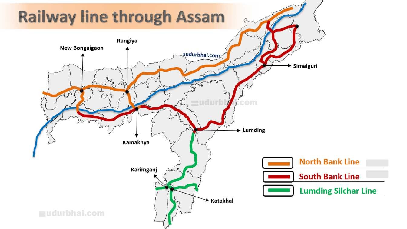
MAJOR RAILWAY ROUTES IN ASSAM
A. North Bank Line
Runs along the north of Brahmaputra River.
Connects:
Rangiya
Rangapara
North Lakhimpur
Tinsukia
B. South Bank Line
Connects:
Guwahati
Lumding
Dibrugarh
Important freight corridor.
C. Lumding–Silchar Line
Connects Barak Valley.
Passes through:
Hill sections
Tunnels & bridges
Engineering significance.
Strategic importance of Railways in Assam
A. Border Security
Connects sensitive border areas:
Arunachal Pradesh
International border with China
Enables:
Rapid troop movement
Military logistics
B. Act East Policy
Railway expansion supports:
India–Myanmar trade routes
Southeast Asian connectivity
C. Disaster Management
Crucial during:
Annual floods
Road disruption
Major Railway infra Projects in Assam
A. Bogibeel Bridge
Rail-cum-road bridge over Brahmaputra River
Connects Dhemaji & Dibrugarh.
Strategic importance.
B. Gauge Conversion
Complete conversion to Broad Gauge.
Improved:
Speed
Freight capacity
C. Electrification
Ongoing electrification of railway lines.
Reduces:
Fuel cost
Carbon emissions
Over 2,500 route km electrified in NE since 2014
D. New Railway Projects
Connectivity to:
Arunachal Pradesh (Naharlagun)
Agartala via Assam
Border railway expansion.
E. High-Speed and Strategic Projects: Vande Bharat services
F. Railway Station Redevelopment:
- Under Amrit Bharat Station Scheme, 60 stations in NE (many in Assam) like Guwahati and Dibrugarh are being modernized with world-class amenities.
Waterways in Assam
Assam possesses one of the most extensive inland water transport (IWT) networks in India due to its mighty river systems. The state’s waterways are not only important for transport and trade, but also for culture, ecology, disaster management, and strategic security.
Assam accounts for over 16% of India’s navigable waterways.
The waterways are primarily dominated by the Brahmaputra and Barak river systems.
Inland Water Transport (IWT) is considered cost-effective, eco-friendly, and fuel-efficient.
Historical Development of Waterways in Assam
- Colonial Era: Waterways were extensively used for transporting tea, coal, timber, and oil; the Brahmaputra served as a major route connecting Assam to Bengal and beyond, with ferries and steamers operated by British companies.
- Post-Independence Decline: Shift to road and rail transport due to partition (loss of access to Chittagong port), floods, and lack of investment; however, Inland Water Transport Department was established in 1958 to manage ferries.
- Revival Phase: Post-2014, focus on National Waterways declaration and integration with Maritime India Vision 2030; key milestones include operationalization of NW-57 (Kopili) in 2025.
Current Status and Statistics of Waterways in Assam
- Navigable Length:
- Total navigable length : 1,985 km.
- Brahmaputra (NW-2) navigable length : 891 km
- Barak (NW-16) navigable length : 121 km.
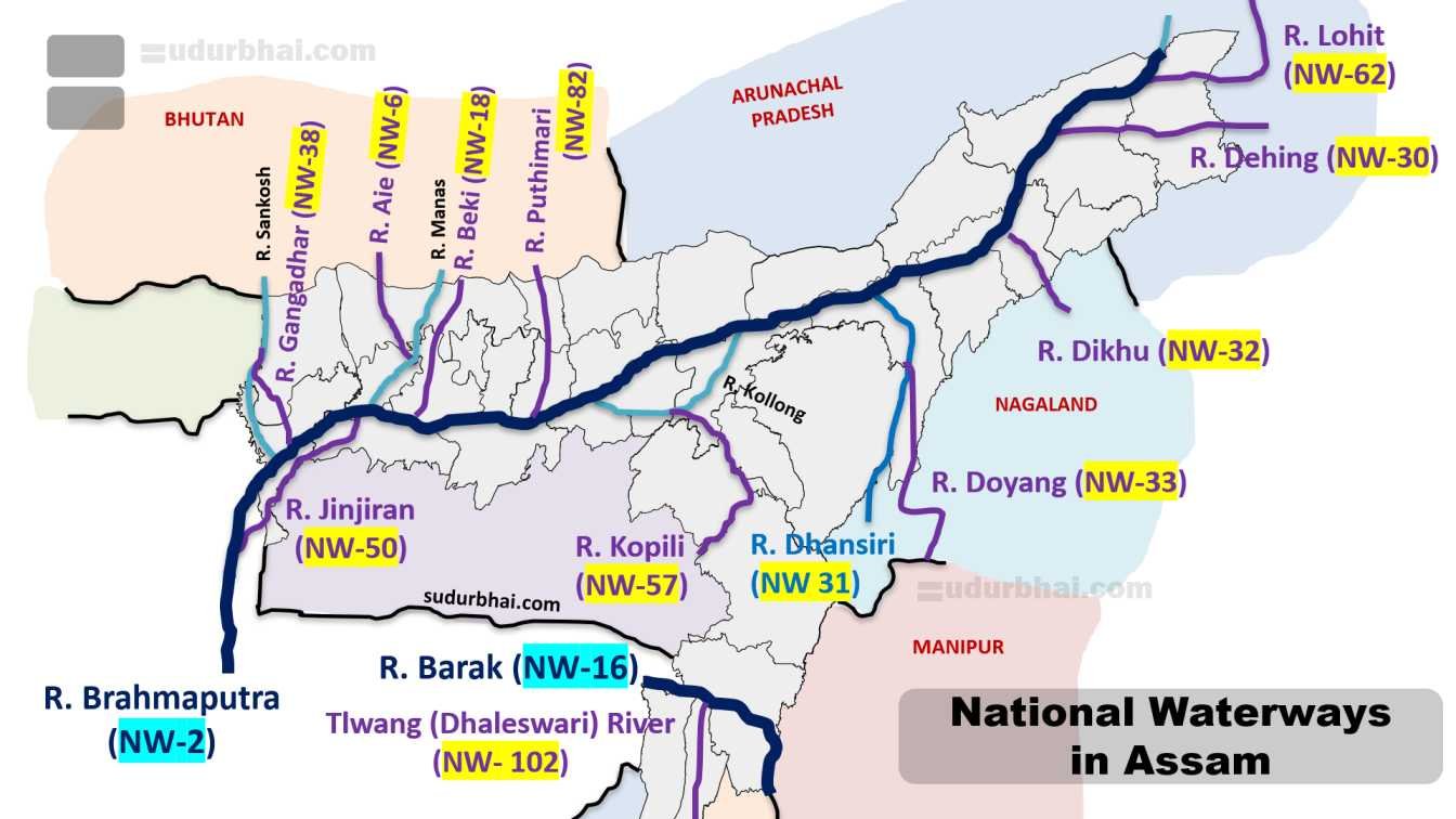
- Total National Waterways in Assam: 15.
- Operational Waterways: Four fully functional National Waterways—
- NW-2 : Brahmaputra River
- NW-16 : Barak River
- NW-31 : Dhansiri River
- NW-57 : Kopili River
- Other Waterways include :
- NW-6: Aai River
- NW-18: Beki River
- NW-30: Dehing River
- NW-31: Dhansiri River
- NW-32: Dikhu River
- NW-33: Doyans River
- NW-57: Kopili River
- NW-82: Puthimari River
- NW-38: Gangadhar River (Assam+ West Bengal)
- NW-50: Jinjiram River (Assam+ Meghalaya)
- NW-62: Lohit River (Assam+ Arunachal Pradesh)
- NW-102: Tlwang (Dhaleswari) River
- Navigable Length:
National Waterways in Assam - Infrastructure: Managed by Inland Waterways Authority of India (IWAI) and Assam Inland Water Transport Development Society (AIWTDS).
- The infrastructure also includes 74 ferry routes, floating terminals, night navigation aids, and vessels for passengers and cargo.
- Cargo and Passenger Traffic:
- Cargo Traffic : Primarily transports bulk goods like coal, cement, food grains, fertilizers, and petroleum;
- Passenger Traffic : Passenger ferries connect remote areas, with growing cruise tourism on Brahmaputra.
Key Waterways in Assam
Brahmaputra River (NW-2)
- Route and Length:
- From Sadiya to Dhubri (891 km),
- Forms the longest inland waterway in India.
- Connects Assam to West Bengal and Bangladesh via Protocol Routes.
- Significance:
- Vital for Northeast connectivity,
- Trade with neighboring countries, and tourism.
- Supports Majuli Island ferries and cargo terminals at Pandu and Dhubri.
- Ongoing developments along NW-2:
- Dredging,
- Channel stabilization, and multi-modal terminals under Jal Marg Vikas Project.
- Plans for 20 new ports.
- Route and Length:
Barak River (NW-16)
- Route and Length:
- From Lakhipur to Bhanga (121 km).
- Flowing through Silchar and connecting to Meghalaya and Bangladesh.
- Significance:
- Enhances cross-border trade and regional ties.
- Used for cargo like fly ash and food grains.
- Developments in NW-16:
- Dredging and terminals.
- Integration with Eastern Waterway Grid.
- Route and Length:
Other Waterways
- Kopili (NW-57): Recently operationalized (2025), from Dakshin Lumding to confluence with Brahmaputra; boosts IWT under PM Gati Shakti.
- Dhansiri (NW-31), Aai, Beki, Lohit, Subansiri: Shorter tributaries supporting local transport and eco-tourism.
Challenges faced by Waterways in Assam
- Geographical and Environmental Challenges:
- Seasonal variations in water levels,
- floods, erosion, and siltation reduce navigability.
- Their optimum use – requires constant dredging.
- Infrastructure Gaps:
- Limited terminals.
- Difficulty in night navigation, and vessel capacity.
- High maintenance costs due to river morphology.
- Economic and Regulatory:
- Low modal share (only 2% of cargo),
- Competition from other transport modes like roads/rail.
- Cross-border issues with Bangladesh.
- Other Issues:
- Slow speed.
- Environmental impact on biodiversity (e.g., Gangetic dolphins).
- land acquisition for ports.
- Geographical and Environmental Challenges:
Government Initiatives and Developments of Waterways in Assam
- National Waterways Act, 2016: Declared 111 NWs nationwide, with focus on Northeast; IWAI oversees development.
- Jal Marg Vikas Project: World Bank-funded for NW-2 and NW-16, including multi-modal terminals, fairway development, and navigation aids; aims for year-round navigation.
- Jalvahak Scheme:
- Incentives for cargo movement on NW-2 and NW-16.
- Promotes private investment and green transport.
- Maritime India Vision 2030 and PM Gati Shakti:
- Targets 200 million tonnes cargo by 2030.
- Integrates with Eastern Waterway Grid for seamless connectivity.
- Other Efforts:
- Ro-Ro/Ro-Pax services
- Cruise vessels, and cross-border protocols with Bangladesh.
- State-level Assam Inland Water Transport Project (AIWT) Project with World Bank aid.
Socio-Economic Impact of Waterways in Assam
- Economic Benefits:
- Reduces transport costs (up to 30% cheaper).
- Boosts trade in commodities and supports industries like tea and oil.
- Enhances connectivity to ASEAN via Act East Policy.
- Social and Employment:
- Improves access to remote areas.
- Generates jobs in shipping, tourism, and maintenance.
- Promotes eco-tourism through river cruises.
- Environmental Advantages:
- Lowers carbon emissions (5 times less than road).
- Aligns with Blue Economy and sustainable development goals.
- Economic Benefits:
Airways in Assam
- Air transport in Assam plays a pivotal role in connecting the Northeast region to the rest of India and internationally, overcoming geographical isolation caused by hilly terrain, rivers, and flood-prone areas.
- It supports economic growth through tourism, trade, medical emergencies, and defense logistics, with Guwahati serving as the primary hub for the Northeast.
Historical Development of Airways in Assam
- Colonial Origins: Air services in Assam began in the early 20th century for transporting tea and other resources; the first airport was Rowriah Airport in Jorhat (established 1928), marking the start of aviation in the Northeast.
- Post-Independence Growth: Lokpriya Gopinath Bordoloi International Airport (Guwahati) was developed in 1958; initial focus on domestic connectivity amid partition challenges and insurgency.
- Modern Era: Post-2014, rapid expansion under UDAN (Ude Desh ka Aam Nagrik) scheme; aircraft movements in Northeast increased with Assam leading the surge.
Current Status and Statistics of Airways in Assam
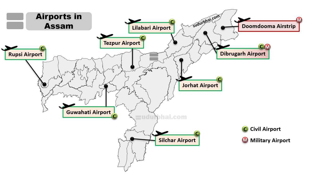
- Number of Airports:
- Assam has 7 operational civil airports (Guwahati, Tezpur, Jorhat, Dibrugarh, Lilabari, Silchar, Rupsi).
- Additionally, military airfields like Tezpur and Chabua support civil operations.
- Passenger Traffic: Over 10 million passengers annually across Assam airports (2024-25 estimates); Guwahati handles 7-8 million, showing a five-fold increase since 2014.
- Aircraft Movements: Assam recorded over 50,000 movements in 2024-25, contributing to Northeast’s growth.
- Connectivity: Domestic flights + Limited international routes from Guwahati to Singapore, Bangkok, and Paro (Bhutan).
- Number of Airports:
Key Airports in Assam
Lokpriya Gopinath Bordoloi International Airport (Guwahati)
- Location and Status: Situated in Borjhar, it’s the 11th busiest airport in India and the only international airport in Assam; handles over 7 million passengers annually.
- Features: New terminal (inaugurated 2025) with nature-themed design, capacity for 13 million passengers.
- Connectivity: Hub for Northeast, with flights to 20+ destinations; international links under Act East Policy.
Dibrugarh Airport (Mohanbari)
- Location and Status: In Upper Assam, serves Dibrugarh and surrounding districts; handles over 500,000 passengers annually.
- Features: Upgraded terminal with night landing facilities; focus on oil and tea industry logistics.
- Connectivity: Flights to Guwahati, Delhi, Kolkata; UDAN routes to smaller towns.
Jorhat Airport (Rowriah)
- Location and Status: Historic airport in Jorhat, operational since 1928; serves central Assam, with 200,000+ passengers.
- Features: Military + civil use; ongoing upgrades for instrument landing system (ILS).
- Connectivity: Links to Guwahati, Kolkata; supports tourism to Majuli.
Silchar Airport
- Location and Status: In Barak Valley, serves southern Assam; handles over 400,000 passengers.
- Features: New terminal under construction; focus on connectivity to Manipur and Tripura.
- Connectivity: Flights to Guwahati, Delhi, Imphal.
Other Airports
- Tezpur Airport (Salonibari): Shared with Indian Air Force; serves Sonitpur district, with UDAN flights.
- Lilabari Airport (North Lakhimpur): Connects Lower Dibang Valley; under development for expanded operations.
- Rupsi Airport (Dhubri): Revived in 2021 under UDAN; serves western Assam and Bangladesh border areas.
Developments and Initiatives
- UDAN Scheme: Launched in 2016, connected underserved airports like Rupsi and Tezpur; over 2.8 lakh flights operated nationally, with Assam benefiting from affordable fares and new routes.
- Infrastructure Upgrades: Rs 4,500 crore allocated for Northeast airports; new terminals in Guwahati, Dibrugarh, and Jorhat.
- International Expansion: Guwahati’s new terminal boosts capacity; plans for more ASEAN links under Act East Policy.
- Sustainability Efforts: Adoption of solar energy and green building norms; integration with multi-modal transport.
Challenges for Airways in Assam
- Geographical and Weather Issues:
- Fog, monsoons, and hilly terrain cause flight delays and cancellations.
- Limited night operations in smaller airports.
- Infrastructure Gaps:
- Overburdened terminals, high operational costs, and limited cargo facilities.
- Northeast airports face low viability due to sparse population.
- Environmental Concerns: Pollution from airports, flooding of runways, and sewerage issues; need for sustainable practices.
- Economic and Regulatory: High fuel taxes, insurgency residues, and slow international clearances hinder growth.
- Geographical and Weather Issues:
Socio-Economic Impact
- Economic Boost: Enhances tourism to Kaziranga, Majuli, and tea estates; supports trade in perishables and handicrafts; generates employment in aviation and ancillary sectors.
- Social Connectivity: Reduces isolation for remote communities, improves access to healthcare and education; fosters cultural exchange in diverse Northeast.
- Strategic Importance: Aids defense along borders; aligns with Viksit Bharat by promoting inclusive growth.
Pipelines in Assam
- Pipelines in Assam are crucial for the transportation of oil and natural gas, making the state a key player in India’s energy sector due to its rich hydrocarbon reserves in the Brahmaputra Valley and Barak Valley.
- These infrastructure networks support refineries, industries, and household consumption, aligning with national goals like increasing natural gas share to 15% in the energy mix by 2030 under India’s NDC.
Historical Development
- Colonial Beginnings: Oil discovery in Digboi (1889) led to early pipeline infrastructure for crude transport. Assam became India’s first oil-producing state of India.
- Post-Independence Expansion: Oil India Limited (OIL) commissioned the Naharkatiya-Barauni Pipeline in 1962, marking the start of large-scale crude oil transportation; natural gas pipelines emerged in the 1960s with fields in Assam and Gujarat.
- Modern Phase: Post-2014, focus on gas grids like Indradhanush Gas Grid (2019) to connect Northeast states, driven by Urja Ganga Scheme and Petroleum and Natural Gas Regulatory Board (PNGRB) regulations.
Current Status and Statistics
- Network Length: For distribution, Assam overall hosts around :
- 2,000 km of oil pipelines
- 1,000 km of steel gas pipelines.
- 30,000 km of PE pipelines.
- Operators: Key players in this sector include :
- Oil India Limited (OIL),
- ONGC
- GAIL
- Assam Gas Company Ltd (AGCL)
- Joint ventures like Indradhanush Gas Grid Ltd (IGGL) and Purba Bharati Gas Pvt Ltd (PBGPL).
- Production Share: Assam contributes :
- 12.29% of India’s crude oil
- 26.48% of natural gas onshore production.
- Network Length: For distribution, Assam overall hosts around :
Key Oil Pipelines
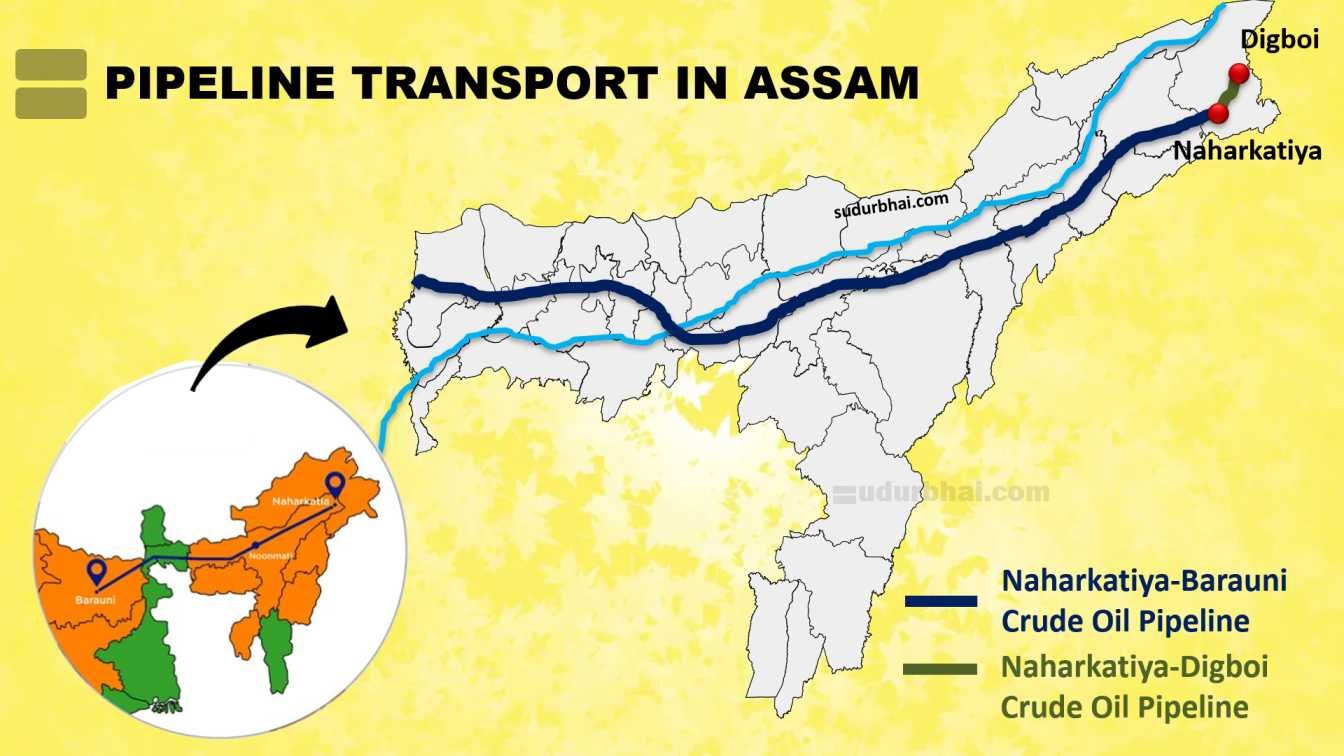
Naharkatiya-Barauni Crude Oil Pipeline
- Route and Length: From Naharkatiya/Duliajan (Assam) to Barauni (Bihar), spanning 1,157-1,247 km across Assam, West Bengal, and Bihar with 78 river crossings.
- Features: Fully automated with 11 pumping stations and 17 repeater stations; bidirectional flow in Bongaigaon-Barauni segment for imported crude.
- Operator and Upgrades: Managed by OIL; recent upgradation projects (Phase I & II, 2012-2021) enhanced capacity and efficiency.
Naharkatiya-Digboi Crude Oil Pipeline
- Route and Length: From Naharkatiya to Digboi Refinery (Assam), 35 km long.
- Features: Transports crude to India’s oldest refinery.
- Operator: Oil India Limited (OIL).
Paradip-Numaligarh Crude Oil Pipeline
- Route and Length: From Paradip (Odisha) to Numaligarh Refinery (Assam), 1,635 km in length, crosses Subansiri River .
- Capacity and Features: Supports refinery expansion; handles imported crude.
- Operator: Numaligarh Refinery Limited (NRL).
Other Oil Pipelines
- Geleki Pipeline: 425 km network for ONGC in Sivasagar district.
- Duliajan-Digboi: Extension for local crude transport.
Key Gas Pipelines
North East Gas Grid (Indradhanush Gas Grid)
- Route and Length: 1,656 km connecting Guwahati to major Northeast cities like Itanagar, Dimapur, Imphal, Aizawl, Agartala, Shillong, Silchar, and Numaligarh.
- Capacity and Features: Designed for bidirectional flow; integrates with Barauni-Guwahati Pipeline under Urja Ganga Scheme.
- Operator and Status: JV of IOCL, ONGC, GAIL, OIL, NRL; expected completion by 2025.
Assam Regional Gas Network (AGCL)
- Route and Length: 1,000 km steel pipelines and 30,000 km PE pipelines across Assam.
- Capacity and Features: Compressor station at Duliajan with 7 MMSCMD capacity; supplies PNG (Piped Natural Gas) and CNG.
- Operator: Assam Gas Company Ltd (AGCL); focuses on domestic and industrial supply.
Purba Bharati Gas Network
- Route and Length: Covers Cachar, Hailakandi, and Karimganj districts in southern Assam.
- Capacity and Features: Provides CNG and PNG for vehicles and households.
- Operator: JV of AGCL, OIL, and GAIL Gas.
Challenges
- Environmental Impacts: Pipelines through protected forests like Kaziranga and Hollongapar Gibbon Sanctuary cause habitat fragmentation and threats to wildlife (e.g., elephants, tigers).
- Geographical Issues: Floods, erosion, and seismic activity in Brahmaputra Valley lead to leaks and maintenance challenges.
- Security and Social: Insurgency risks, land acquisition disputes, and community opposition delay projects.
- Economic: High construction costs in hilly terrain; dependence on imported crude affects efficiency.
Government Initiatives and Developments
- National Policies: Hydrocarbon Vision 2030 for Northeast promotes pipeline expansion. Petroleum and Natural Gas Regulatory Board (PNGRB) regulates networks.
- Projects:
- North East Gas Grid under Maritime India Vision 2030.
- Paradip-Numaligarh Pipeline for refinery expansion.
- Sustainability: Focus on leak detection systems, Horizontal Directional Drilling (HDD) techniques (to install underground pipelines) , and environmental clearances to minimize impacts.
- PNG National Drive 2024 (launched by PNGRB) – Promotes clean energy adoption in Assam.
Socio-Economic Impact
- Economic Benefits:
- Boosts refineries like Numaligarh, Digboi, and Bongaigaon
- Supports employment in upstream and midstream sectors.
- Helps in enhancing trade with ASEAN via Act East Policy.
- Social Advantages:
- Provides PNG for households and CNG for vehicles.
- Reduces pollution and LPG dependency.
- Improves energy access in remote areas.
- Strategic Role:
- Ensures energy security.
- Contributes to India’s natural gas goals by connecting indigenous sources
- Economic Benefits: