
Sun is the major source of atmospheric temperature. In fact, the atmosphere receives a very low amount of heat energy directly from the Sun. This may sound surprising, but most of the Sun’s energy first heats the Earth’s surface, and then the surface sends this heat back into the atmosphere in the form of long-wave terrestrial radiation. This is why the atmosphere is mainly heated from below, not directly from above.
The heating and cooling of the atmosphere take place through two main ways:
- Direct solar radiation reaching the Earth
- Transfer of heat from the Earth’s surface through processes like conduction, convection, and radiation
In simple terms, the Sun heats the land and oceans, and then the land and oceans heat the air around them.
Temperature belts of world
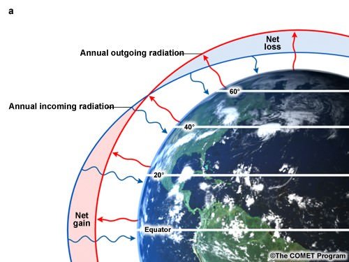
The Earth is divided into different temperature belts (heat zones) based on how much sunlight different regions receive. This mainly depends on their distance from the Equator, because the Equator receives the most direct sunlight.
The three major heat zones of the Earth are:
- Temperate Zone
- Torrid Zone
- Frigid Zone

Torrid Zone (Tropical Zone)
- The Torrid Zone is the hottest region of the Earth because it receives the most direct sunlight.
- It lies between the Tropic of Cancer (23.5°N) and the Tropic of Capricorn (23.5°S)
- The Equator (0° latitude) runs through the center of this zone
- The Sun’s rays fall vertically (directly overhead) at least once every year
- Because the sunlight is direct and concentrated:
- Heat is intense and consistent throughout the year
- There is very little variation in temperature between seasons
Temperate Zone
- The Temperate Zone is considered the most comfortable and suitable region for human living.
- It lies between 23½° and 66½° latitude in both hemispheres
- These areas receive moderate sunlight
- As a result:
- Temperatures are neither extremely hot nor extremely cold
- There are distinct seasons such as summer, winter, spring, and autumn
- Weather conditions are generally more stable and predictable
Frigid Zone
- The Frigid Zone is the coldest region on Earth.
- It lies beyond the Arctic Circle (66.5°N) in the Northern Hemisphere
- And beyond the Antarctic Circle (66.5°S) in the Southern Hemisphere
- Key characteristics:
- Receives very little sunlight, especially during winter
- Experiences long periods of darkness (polar night)
- Temperatures remain extremely low, often below freezing
- Large areas are covered with ice and snow
Importance of the Heat Zones
- Dividing the Earth into heat zones is very useful because it helps us:
- Understand global climate patterns
- Study weather conditions in different regions
- Identify areas suitable for agriculture, settlement, and biodiversity
Factors affecting Temperature patterns on the globe
The temperature at any location on Earth is influenced by several important factors:
- Latitude
- Transparency of Atmosphere
- Land Sea Differential Temperature
- Earth’s distance from Sun
- Sunspots
- Altitude
- Distance from ocean and Seas
- Ocean Currents
- Type of Land Surface
- Effect of slope aspect
Latitude
Latitude is the distance of a place from the Equator, and it plays a major role in determining temperature.
- Areas near the Equator → High temperature
- Areas near the poles → Low temperature
Reason:
- The Earth is spherical (curved)
- At the Equator, the Sun’s rays fall at a 90° angle (vertical), concentrating heat in a small area
- Towards the poles, the rays fall at a slant, spreading the same energy over a larger area, reducing heat intensity
Transparency of Atmosphere
- The transparency of the atmosphere determines how much sunlight can pass through it and reach the Earth.
- Factors that reduce transparency:
- Dust and smoke (aerosols)
- Water vapour
- Clouds
- How radiation behaves in the atmosphere:
- If radiation wavelength is larger than particles, it gets scattered
- If it is smaller than particles, it gets reflected
- Gases like water vapour, ozone, and carbon dioxide absorb radiation
- Because of these processes, most of the light reaching Earth is actually scattered light, not direct sunlight.

Land-Sea Differential
- Land and water behave differently when they receive heat, which affects temperature patterns.
- Land has a higher albedo (reflectivity) than water
- Snow-covered areas can reflect up to 70–90% of sunlight
- Key differences:
- Land heats up and cools down quickly
- Water heats up and cools down slowly
- Reason:
- Sunlight can penetrate deeper into water (up to 20 meters)
- On land, it penetrates only about 1 meter
- Water continuously circulates (convection), distributing heat evenly
- Because of this, coastal areas have moderate temperatures, while inland areas experience extreme temperatures.

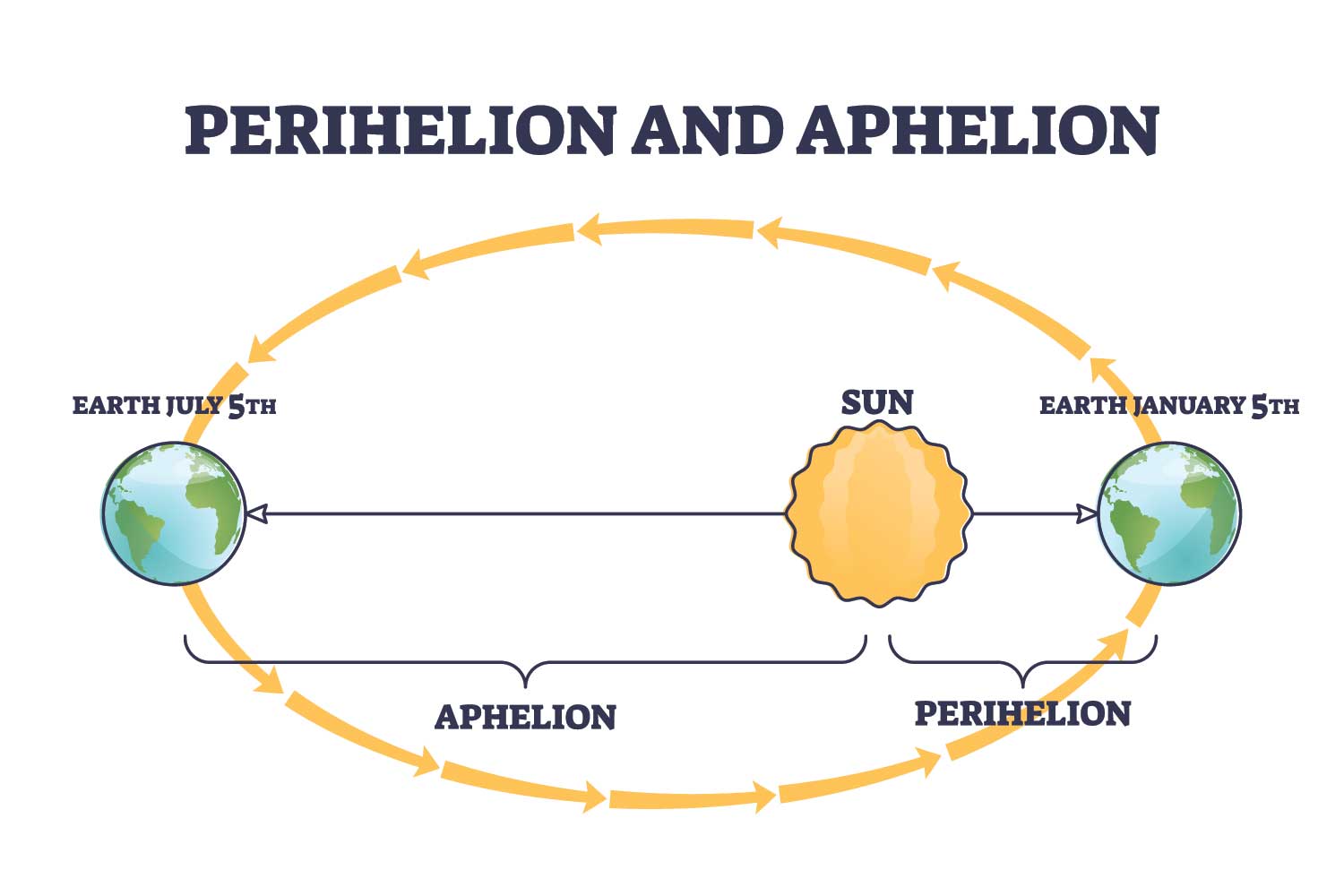
Earth’s Distance form Sun
The Earth’s distance from the Sun changes slightly during its orbit:
| Position | Distance | Time |
|---|---|---|
| Aphelion (farthest) | 152 million km | Around 4th July |
| Perihelion (nearest) | 147 million km | Around 3rd January |
- Earth receives slightly more solar energy in January
- However, this difference has very little impact on weather, because other factors are more important.
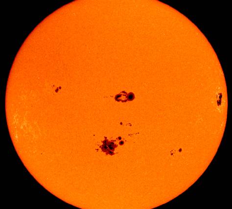
Sunspots
- Sunspots are dark regions on the Sun caused by disturbances and explosions on its surface.
- They follow a cycle of about 11 years
- When sunspots increase, the Sun emits more energy
- This can slightly increase insolation on Earth
Altitude
- Altitude means the height of a place above sea level.
- High altitude (mountains) → Low temperature
- Low altitude (plains) → High temperature
- Reasons:
- Air becomes thinner at higher altitudes
- There is less water vapour to absorb heat
- Therefore, less heat is retained, making high places cooler
Distance from the Sea
- The distance from the sea greatly affects temperature.
- Maritime Influence :
- Coastal areas are influenced by nearby oceans
- In summer → sea keeps temperature cooler
- In winter → sea keeps temperature warmer
- This results in a moderate climate near the coastal regions.
- Continental Influence
- Inland areas are far from the sea
- Experience extreme temperatures
- Summers → very hot
- Winters → very cold
Ocean Currents
- Ocean currents are large streams of moving water in oceans.
- Types:
- Warm currents → bring warm water
- Cold currents → bring cold water
- Effects:
- Warm currents make nearby areas warmer
- Cold currents make nearby areas cooler
Types of land surface
- Different surfaces absorb heat differently:
- Dense forests
- Block sunlight
- Keep ground cool
- Urban areas (cities)
- Concrete absorbs and stores heat
- Makes cities warmer, especially at night
- This is known as the urban heat island effect
- Dense forests
- Aspect – Aspect refers to the direction a slope faces in relation to the Sun.
- In tropical regions → less important
- In temperate regions → very important
- Example:
- In the Northern Hemisphere:
- South-facing slopes receive more sunlight → warmer
- North-facing slopes receive less sunlight → cooler
- In the Northern Hemisphere:
Mean Annual Temperature Distribution
- Isotherm – An imaginary line joining places having the same temperature.
- Used to represent temperature patterns on maps
- Helps in understanding heat distribution across Earth
- General characteristics of isotherms:
- Usually follow lines of latitude
- Bend near land and ocean boundaries
- Close spacing → rapid temperature change
- Wide spacing → slow temperature change
- General Temperature Distribution
- Highest temperatures occur in tropical and subtropical regions
- Lowest temperatures occur in polar regions
- Continental interiors show high variation in temperature
- Oceans show low variation due to water’s heat capacity
- Other key observations:
- Tropics have low temperature variation
- Middle and high latitudes have high variation
- Eastern coasts are warmer due to warm currents
- Western coasts are cooler due to cold currents
- Mountains also affect temperature by blocking air movement and influencing wind patterns.
Inter Tropical Convergence Zone
- The Inter-Tropical Convergence Zone (ITCZ) is a region near the Equator where:
- Trade winds from both hemispheres meet
- Air rises, creating low pressure and heavy rainfall
- This zone shifts north and south with the apparent movement of the Sun.
Seasonal Temperature Distribution
Temperature distribution changes with seasons and can be studied using isotherm maps for January and July.
Seasonal Temperature Distribution – January
- Northern Hemisphere → Winter
- Southern Hemisphere → Summer
Northern Hemisphere
- Oceans remain warmer than land
- Warm currents raise temperatures
- Cold winds cool land areas significantly
- Extremely low temperatures occur in Siberia and Greenland
Southern Hemisphere
- Temperature variation is more uniform
- Isotherms are mostly parallel
- High-temperature belt lies near 30°S
- Thermal equator shifts southward
Seasonal Temperature Distribution – July
- Northern Hemisphere → Summer
- Southern Hemisphere → Winter
Northern Hemisphere
- Land becomes very hot
- Isotherms bend toward the poles
- High temperatures occur in continental interiors
Southern Hemisphere
- Temperature distribution remains more regular
- Thermal equator shifts northward
Vertical Distribution of Temperature
- Temperature decreases with height in the troposphere
- This decrease is called the lapse rate (decrease of temperature by 6.4°C with 1 km altitude)
- At the tropopause, temperature becomes constant
- In higher layers, temperature may increase again
Temperature Anomaly
- A temperature anomaly is the difference between the actual temperature of a place and the average temperature of its latitude.
- Larger anomalies occur in the Northern Hemisphere
- Smaller anomalies occur in the Southern Hemisphere
Vertical Distribution of Temperature
- The thermal equator is an imaginary line connecting places with the highest average annual temperature.
- It does not exactly match the geographical Equator
- It usually lies around 5°N latitude

- Reasons:
- Uneven distribution of land and water
- Ocean currents and wind systems
- Seasonal movement of the Sun
The thermal equator shifts north and south throughout the year but generally stays slightly north of the Equator, mainly because the Northern Hemisphere has more land, which heats up faster than water.