Sribhumi (Karimganj) District

District Overview: Sribhumi (Karimganj) District

    • Location: Situated in the southern part of Assam, India.
    • Established: 1983.
    • Significance: Known for its cultural diversity, agricultural economy, and strategic position near the Bangladesh border. It plays an important role in trade and commerce in the region.

History of Karimganj (Sribhumi)

1. Early History and Formation

    • Medieval Era:

      • In the Middle Ages, Karimganj was part of Bangla Suba (the Bengal Province under the Mughal Empire) and the Sylhet Sarkar.

    • British Colonial Rule:

      • The British East India Company gained control over Sylhet (including Karimganj) in 1765, but full authority was only established by 1786.

      • In 1778, Karimganj became a subdivision of Sylhet district, initially consisting of 40 parganas (administrative units).

    • Origin of the Name “Karimganj”:

      • The name is derived from Muhammad Karim Chowdhury, a Bengali Muslim landowner who founded a local market.

      • Originally located near the Natikhal and Kushiyara rivers, the market was later shifted to its present location (district HQ) in the 1870s, due to the Natikhal River drying up in autumn.

2. Partition and Reorganization

    • Partition of India (1947):

      • A plebiscite was held to decide whether Sylhet (including Karimganj) would remain in India or join Pakistan.

      • Sylhet voted to join Pakistan, but some areas (including Karimganj) remained in India to maintain connectivity with Tripura.

      • The Kushiyara River became the new international border between India and East Pakistan (now Bangladesh).

    • Formation of Karimganj District (1983):

      • July 13, 1983: Karimganj was upgraded from a subdivision to a full-fledged district.

3. Renaming as “Sribhumi” (2024)

    • November 21, 2024: Karimganj was officially renamed “Sribhumi”.

    • The renaming honors Rabindranath Tagore, who viewed the region as the land of the goddess Lakshmi (Sribhumi = “Auspicious Land”).

    • The change also recognizes the district’s cultural and historical significance.


Geography of Sribhumi (Karimganj) District

    • Area: About 1,828 square kilometers.
    • Coordinates: Approximately 24°52′ N latitude and 92°22′ E longitude.
    • Boundaries:
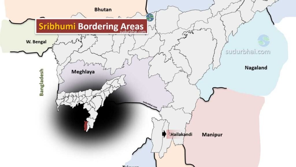
      • North: Borders Hailakandi and Cachar districts.
      • South: Shares its boundary with Bangladesh.
      • East: Adjacent to Karimganj district.
      • West: Borders Hailakandi and Dima Hasao districts.
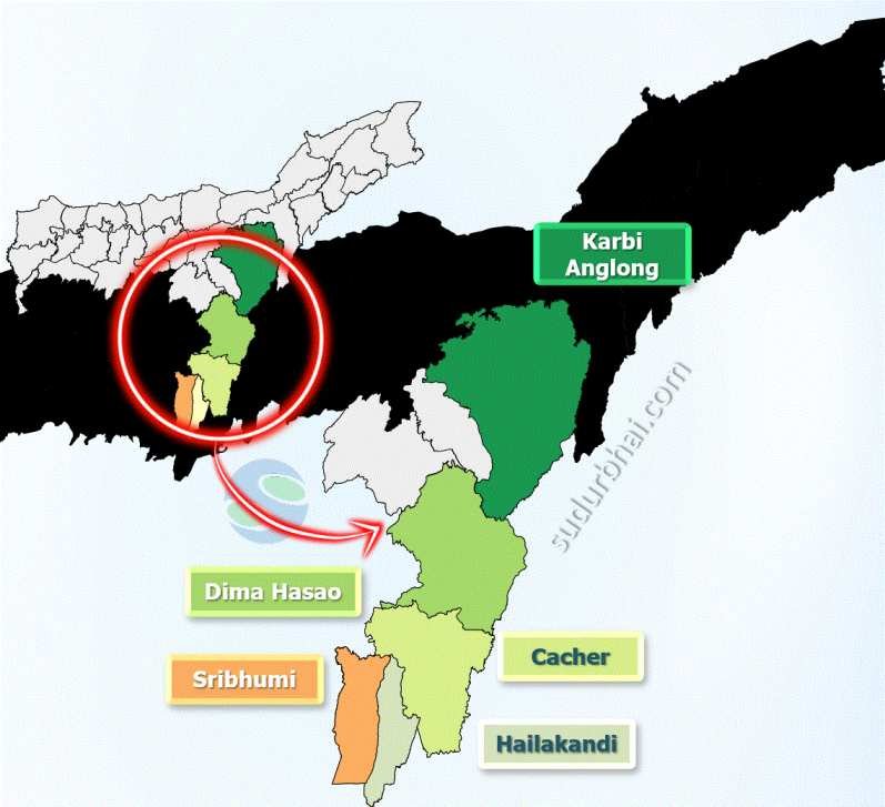
    • Topography: Features fertile plains and hilly terrains, shaped by the Brahmaputra River and its tributaries.
    • Rivers: Major rivers include Kushiara, Dudhpatil, and Piyang.
    • Climate:
      • Humid subtropical with heavy rainfall (average 2,500 mm annually) from June to September.
      • Rain contributes to soil fertility but may cause flooding.
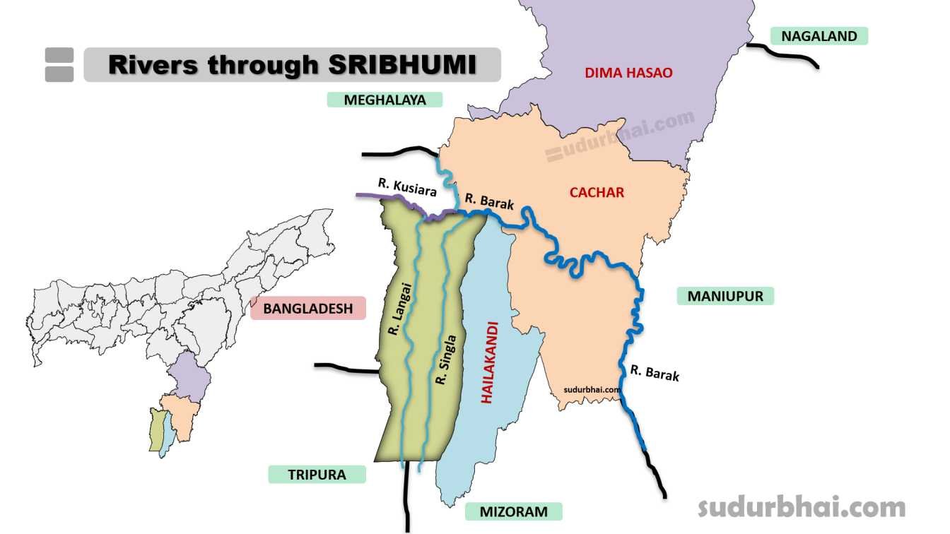
Socio-Economy of Sribhumi (Karimganj) District

    • Agriculture: Main source of livelihood with crops like rice, jute, mustard, tea, and banana.
    • Livestock: Farming of cattle, goats, and poultry is common.
    • Trade & Commerce:
      • Karimganj is a border trade hub with Bangladesh, especially at the Sutarkandi border point.
      • Trade includes goods like food items and textiles.
    • Small-Scale Industries: The district has industries like food processing, bamboo crafts, and handicrafts.

Transport in Sribhumi (Karimganj) District

    • Roadways: Well-connected by National Highway 44, linking Karimganj to other cities in Assam.
    • Railways: The Karimganj Railway Station connects the district to other regions.
    • Airways: The nearest airport is in Silchar, about 70 km from Karimganj town.

Demographics of Sribhumi (Karimganj) District

    • Population: The total population of Karimganj District was 1,228,686
      • Male: 625,864
      • Female: 602,822
    • Urban vs. Rural Population:
      • Urban: 8.93%
      • Rural: 91.07%
    • Sex Ratio: 963 females per 1000 males
    • Child Sex Ratio (0-6 years): 969 girls per 1000 boys
    • Children (Age 0-6): 17% of the total population
    • Literacy Rate: 78.22%.
      • Urban: 92.8%
      • Rural: 76.7%
    • Scheduled Castes: 12.9% of the total population
    • Scheduled Tribes: 0.2% of the total population
    • Religion:
      • Muslims: 56.36%
      • Hindus: 42.48%
      • Christians: 0.98%
      • Sikhs: 0.01%
      • Buddhists: 0.04%
      • Jains: 0.04%
      • Others: 0.01%
      • Not Available: 0.09%
    • Population Density: 679 people per square kilometer
    • Population Growth Rate (2001-2011): 21.90%

Administrative Setup of Sribhumi (Karimganj) District

    • District Headquarters: Karimganj town.
    • Sub-Divisions: Includes Karimganj Sadar and Badarpur.
    • Revenue Circles: Several circles including Karimganj Circle and Badarpur Circle.
    • Development Blocks: Multiple blocks for local governance and development.

Rainfall in Sribhumi (Karimganj) District

    • Average Annual Rainfall: Between 2,500 mm to 3,000 mm, with most rain falling from June to September.
    • Flooding Risk: Heavy rain can cause flooding but also improves soil fertility for agriculture.

Tourist Places in Sribhumi (karimganj)

Nature and Scenery:

    • Chhatachura Range: Located in the southeastern part of Karimganj, this range is known for its scenic beauty. The highest peak is at 2087 feet
    • Son Beel: This is the largest wetland in Karimganj and Southern Assam, offering a picturesque landscape with hills to its east and west. The Shingla River passes through it
    • River Kushiara: Take a boat ride on the scenic River Kushiara
    • Eolabari Tea Estate: A great place to relax and connect with nature, located 15 km from Karimganj
    • Maibong Hill Station: Explore the lush landscapes of Maibong Hill Station
    • Adamail Range & Duhalia Range: Karimganj has various hill ranges namely Adamail range, Duhalia range

Historical Sites:

    • Badarpurghat: A historical fort built by the British, located on the banks of the Barak River
    • Malegarh Crematorium: A memorial to soldiers who lost their lives during the Sepoy Mutiny of 1857

Other Attractions:

    • Kachakanti Temple: Visit the ancient Kachakanti Temple
    • Assam State Zoo and Botanical Garden: Experience the wildlife

Languages Spoken in Sribhumi (Karimganj) District

    • Bengali: 86.84%
    • Hindi: 5.70%
    • Bishnupriya: 2.00%
    • Bhojpuri: 1.65%

Let us know any further suggestions ,we at sudurbhai.com will be happy to hear from you in our comment section below ! 

Leave a Comment

Your email address will not be published. Required fields are marked *

Scroll to Top