Nagaon District

Nagaon District

  District Overview of Nagaon District

    • Location: Central Assam, India.
    • Significance: Known for agricultural richness, cultural diversity, and historical importance. Nagaon plays a key role in the socio-economic landscape of Assam.
    • Administrative Headquarters: Nagaon town.
Nagaon District

  History of Nagaon District

Early History:
    • The name “Nagaon” derives from “Na” (new) + “Gaon” (village) → meaning “New Village.”

    • Eastern, western, and southern fringes were ruled by small feudal kings or their agents.

Under Burmese Rule:
    • Nagaon remained under Burmese rule until 1826.

British Rule:
    • Came under British control after the Treaty of Yandaboo (1826).

    • Nagaon was established as a separate administrative district in 1832 (or 1833, as per another source).

    • 1839: Present-day Nagaon town, initially called Khagorijan, was settled as district HQ, later renamed Nowgong.

    • 1893: Became a municipality.

Recent History:
    • Judicial activity began in 1967 with the formation of the District Judge Court.

    • August 15, 2016: Three tehsils were separated to form the Hojai district.

  Geography of Nagaon District

    • Area: Covers about 2,287 square kilometers.
    • Coordinates: Between 25°45′ N to 26°45′ N latitude and 91°50′ E to 93°20′ E longitude.
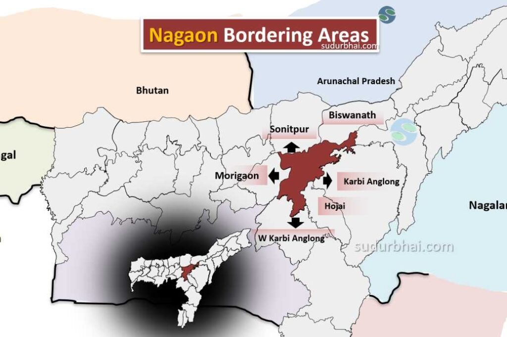
    • Boundaries:
      • North: Sonitpur , Bishwanath district.
      • South: West Karbi Anglong.
      • East: HojaiKarbi Anglong districts.
      • West: Morigaon district.
  • Nagaon Nearby districts
    Nagaon Neighbouring districts
    • Topography: Mostly fertile alluvial plains with some hilly areas. The district has numerous rivers and wetlands.
    • Rivers: Major rivers include Kopili, Kalong, Sonai, and Dikrong.
    • Climate: Humid subtropical climate with an average annual rainfall of about 1,500 mm, mostly between June to September.
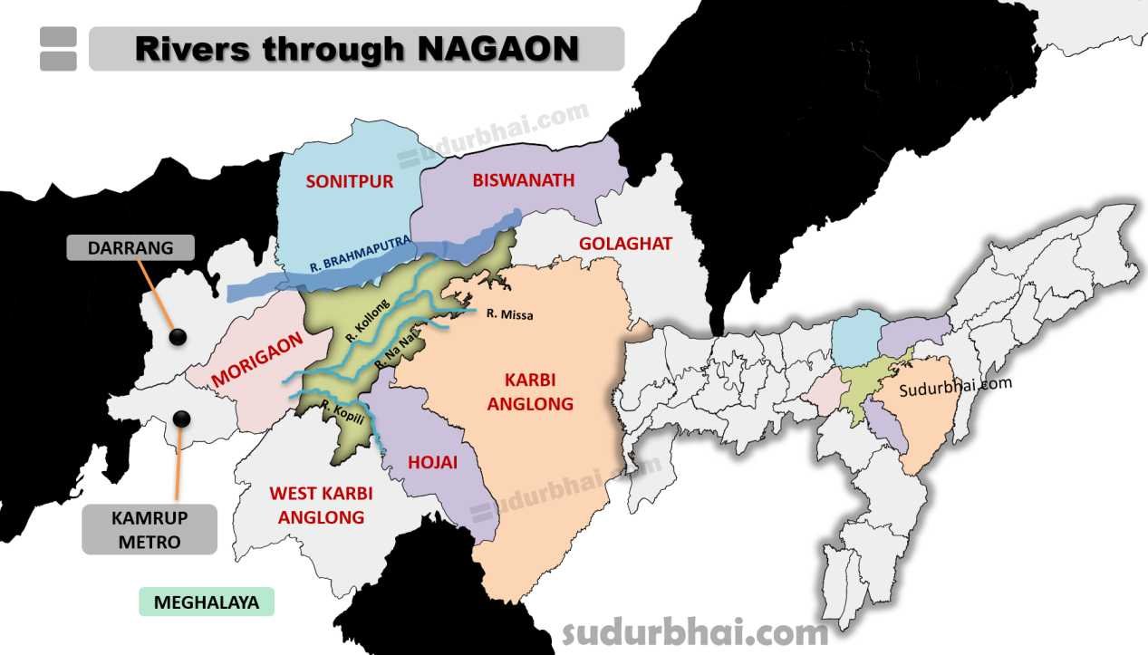
 Socio-Economy of Nagaon District

    • Agriculture: The district’s economy is largely agrarian. Major crops include rice, jute, mustard, potatoes, and various vegetables.
    • Livestock Farming: Cattle, goats, and poultry farming play an important role in the economy.
    • Small-scale Industries: Includes industries focused on food processing, jute manufacturing, and bamboo crafts.
    • Trade and Commerce: Nagaon is a trade hub for agricultural products and handicrafts, with a strong presence of jute mills.

 Transport in Nagaon District

    • Roadways: Well-connected with roads, including National Highways 36 and 37, making travel easy within the state.
    • Railways: Nearest railway stations are in Chaparmukh and Lumding, providing connections to other regions.
    • Airways: The nearest airport is in Guwahati, about 120 km away, linking Nagaon to major Indian cities.

 Demographics of Nagaon District

Population Overview
    • Total Population: 2,823,768

      • Males: 1,439,112 (50.94%)

      • Females: 1,384,656 (49.06%)

    • Sex Ratio: 962 females per 1000 males

    • Child Population (0-6 years): 459,940 (16.29% of total population)

      • Male Children: 234,203

      • Female Children: 225,737

    • Child Sex Ratio: 964 girls per 1000 boys

Rural and Urban Distribution
    • Rural Population: 2,454,234 (86.91%)

      • Males: 1,250,985

      • Females: 1,203,249

    • Urban Population: 369,534 (13.09%)

      • Males: 188,127

      • Females: 181,407

Literacy Rates
    • Overall Literacy Rate: 72.37%

      • Male Literacy Rate: 76.51%

      • Female Literacy Rate: 68.07%

    • Urban Literacy Rate:

      • Average: 87.23%

        • Male: 90.58%

        • Female: 83.76%

    • Rural Literacy Rate:

      • Average: 69.96%

        • Male: 74.22%

        • Female: 65.52%

Caste Composition
    • Scheduled Castes (SC): Constitute approximately 9.4% of the population.

    • Scheduled Tribes (ST): Constitute about 4.1% of the population.

 Administrative Setup of Nagaon District

    • District Headquarters: Nagaon town.
    • Sub-Divisions: The district has three sub-divisionsNagaon Sadar, Kaliabor, and Raha.
    • Revenue Circles: Seven revenue circles in the district.
    • Development Blocks: Thirteen blocks for local governance and development.

 Attractive Tourist Places in Nagaon

    • Kaziranga National Park: A UNESCO World Heritage site, home to the Indian one-horned rhinoceros.
    • Lowkhowa Wildlife Sanctuary: A protected area with diverse flora and fauna.
    • Champawati Kunda Waterfall: A scenic waterfall near Chapanala.
    • Temples: Including Bratadowa Than (Baishanvi Temple), showcasing Assamese traditions.
    • Historical Sites: Relating to the Ahom dynasty and local folklore.
    • Samaguri Beel: An ox-bow shaped wetland and lake, also known as Pokhi Tirtha (bird pilgrimage). It is a haven for migratory birds, especially during the winter months.
    • Samaguri Satra: A religious and cultural center preserving the tradition of mask-making and local artworks.
    • Laokhowa Wildlife Sanctuary: Home to the great Indian one-horned rhino, leopard, tiger, hog deer, and wild cat.
    • Silghat: Known for its ancient temples and a river port along the Brahmaputra River. The Trishuldhari Silghat Temple offers a panoramic view of the Brahmaputra.
    • Jungal Balahu Garh: This site features a statue of the Tiwa king and brave warrior, Jungal Balahu, and a departmental fishery.
    • Hodhodi: A natural waterfall in Lung Chung, approximately 35 km from Nagaon, surrounded by tea gardens and hills

 Languages Spoken in Nagaon District

    • Assamese: 77.17%
    • Bengali: 16.75%
    • Hindi: 1.31%

Let us know any further suggestions ,we at sudurbhai.com will be happy to hear from you in our comment section below ! 

Leave a Comment

Your email address will not be published. Required fields are marked *

Scroll to Top