Kokrajhar District

District Overview: Kokrajhar District

    • Location: In the Bodoland Territorial Region of Assam, India.
    • Significance: Known for its rich cultural heritage, diverse ethnic communities, and being a gateway to northeastern India. The district has both historical and economic importance.
    • Geographical Area: About 3,169.22 square kilometers.

     History of Kokrajhar District

1. Early History

    • Bhutanese Rule (17th Century – 1865):

      • The present-day Kokrajhar district was under the control of the Kingdom of Bhutan until the Duar Wars (1865).

      • After the war, the British removed Bhutanese influence and merged the region into the undivided Goalpara district in 1949.

    • Koch Rajbongshi Influence:

      • Kokrajhar was historically part of the Bijni kingdom, ruled by Koch Rajbongshi kings.

2. Development as a District

    • 1957: Kokrajhar was carved out of Goalpara district for administrative purposes.

    • 1983: Kokrajhar was upgraded to a full-fledged district, with four police stations:

      • Bijni, Sidli, Kokrajhar, and Gossaigaon

      • The total area was 4,065.88 sq. km.

    • 1989: Bongaigaon district was created, taking parts from Kokrajhar and Goalpara.

    • 2009:

      • Chirang district was created, reducing Kokrajhar’s size.

      • Parts of Dhubri district were merged into Kokrajhar.

      • The present area of the district stands at 3,169.22 sq. km.

3. Additional Historical Facts

    • Cultural & Administrative Development:

      • Kokrajhar District Museum was officially declared a District Museum in 1986.

      • 1951: The Court of Kokrajhar was established as EAC and Magistrate Court.

      • 1954 (October 16): The Munsiff Court was opened.

    • Urban & Educational Growth:

      • 1956: Kokrajhar Town Committee was formed.

      • 1970: The town committee was upgraded to a Municipal Board.

      • 1957 (August 15): Electricity was introduced in Kokrajhar.

      • Educational Institutions:

        • Kokrajhar College – Established in 1959.

        • B.T. College – Founded in 1971.

        • Law & Commerce Colleges – Started in 1986.


Geography of Kokrajhar District

    • Coordinates: Between 26°19′ N to 26°54′ N latitude and 89°46′ E to 90°38′ E longitude.
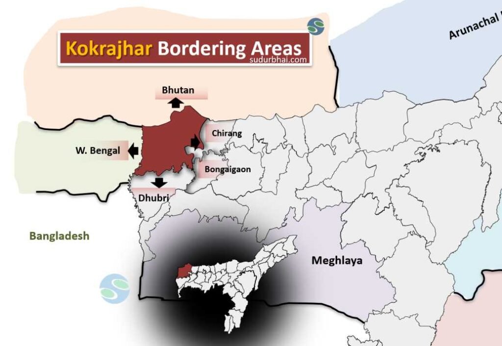
    • Boundaries:
      • North: Borders Bhutan.
      • South: Borders Dhubri district.
      • East: Adjacent to Chirang district.
      • West: Borders West Bengal.
    • Topography: A mix of hills (Bodoland Hills) and fertile plains.
    • Rivers: Major rivers include Champamati, Gaurang, Tipkai, and Sankosh.
    • Climate: Humid subtropical with heavy rainfall (2,500 mm annually), especially during the monsoon season (June to September).

Socio-Economy of Kokrajhar District

    • Agriculture: Main livelihood with crops like rice, jute, mustard, and tea.
    • Livestock: Cattle, goats, and poultry farming are common.
    • Small-scale Industries: Includes bamboo crafts, weaving, and food processing.
    • Tourism Potential: The district has a rich cultural heritage and natural beauty, attracting tourists interested in indigenous cultures and scenic landscapes.

Transport in Kokrajhar District

    • Roadways: Well-connected by National Highway 31(C), linking Kokrajhar to other parts of Assam.
    • Railways: The Kokrajhar Railway Station provides connectivity to other regions.
    • Airways: The nearest airport is in Bagdogra, West Bengal, about 150 km away from Kokrajhar town.

Demographics of Kokrajhar District

    • Population and Urban/Rural Distribution:
      • Total Population: 887,142
      • Rural Population: 93.81%
      • Urban Population: 6.19%
      • Population Density: 280 per Sq. Km
      • Population Growth Rate (2001-2011): 5.19%
      • Kokrajhar District population constituted 2.84 percent of total Maharashtra population

      Sex Ratio:

      • Average Sex Ratio: 959 females per 1000 males
      • Urban Sex Ratio: 931 females per 1000 males
      • Rural Sex Ratio: 961 females per 1000 males
      • Child Sex Ratio (0-6 years): 954 girls per 1000 boys
      • Urban Child Sex Ratio (0-6 years): 947 girls per 1000 boys

      Literacy:

      • Literacy Rate: 66.63%
      • Urban Literacy Rate: 87.9%
      • Rural Literacy Rate: 63.6%
      • Male Literacy: 73.44%
      • Female Literacy: 59.54%
      • Urban Male Literacy: 91.97%
      • Urban Female Literacy: 83.44%
      • Rural Male Literacy: 70.45%
      • Rural Female Literacy: 56.53%

      Children (0-6 years):

      • Child Population (0-6 years): 15% of the total population
      • Child Population in rural areas is 15.84% of the total rural population

      Caste and Religion:

      • Scheduled Castes: 3.33% of the population
      • Scheduled Tribes: 31.41% of the population

Administrative Setup of Kokrajhar District

    • District Headquarters: Kokrajhar town.
    • Sub-Divisions: Kokrajhar Sadar, Gossaigaon, and Parbatjhora.
    • Revenue Circles: Kokrajhar, Dotma, Bhowraguri, Gossaigaon, and Bagribari.
    • Development Blocks: Includes Kokrajhar (Titaguri), Dotma, Kachugaon, Gossaigaon, and others.

Rainfall in Kokrajhar District

    • Average Annual Rainfall: Between 2,500 mm and 3,000 mm.
    • Monsoon Impact: Heavy rainfall can cause flooding, but it also helps improve soil fertility for farming.

Tourist Places in Kokrajhar

    • Chakrashila Wildlife Sanctuary: Known for its rich biodiversity and home to endangered species like the golden langur and Bengal Florican. The sanctuary is spread over Chakrashilla Hill, covering an area of 45.568 square kilometers
    • Raimona National Park: This park is known for its scenic landscapes and diverse flora and fauna. It is part of the Manas Biosphere Reserve, a UNESCO World Heritage site, and home to endangered species like the Bengal tiger, Indian elephant, and clouded leopard. 
    • Saralpara Picnic Spot: Near the India-Bhutan border, this spot offers scenic beauty with waterfalls, rivulets, and mountains. It’s a popular place for picnics, especially in winter and summer.
    • Mwsha Hokdao Picnic Spot: Located near Alayaran Anath Ashram, close to Chakrashila Wildlife Sanctuary. It is about 12 km from Kokrajhar town.
    • Gaurang Park: A family park located in Chandamari where visitors of all ages can enjoy. It offers scenic views of the nearby Gaurang River
    • Diplai Beel: A natural wetland and bird sanctuary with a variety of local and endangered bird species. It is located 22 kilometers away from Kokrajhar town
    • Dheer Beel: A freshwater lake within Chakrashila Wildlife Sanctuary that is a popular picnic spot
    • Yamao Chara Boating Park: Located in Chandamari near a tea garden, this park is known for its natural beauty and calmness
    • Pepsu Picnic Spot: Located 55 km away from Kokrajhar town, near the Bhutan border

Languages Spoken in Kokrajhar District

    • Boro: 28.39%
    • Assamese: 19.92%
    • Bengali: 17.78%
    • Santali: 11.90%
    • Rajbongshi: 7.62%
    • Rabha: 2.58%
    • Hindi: 1.76%
    • Nepali: 1.65%
    • Kurukh: 1.42%
    • Garo: 1.21%

Let us know any further suggestions ,we at sudurbhai.com will be happy to hear from you in our comment section below ! 

Leave a Comment

Your email address will not be published. Required fields are marked *

Scroll to Top