District Overview: Karbi Anglong District
- Location: In the central part of Assam, India.
- Established: 1951.
- Significance: Known for its cultural diversity, tribal communities, and scenic landscapes. It is an autonomous district under the Sixth Schedule of the Indian Constitution.
History of Karbi Anglong District
1. Early History and Formation
Before British colonization, the hill tribes of the region, including the Karbi people, lived in autonomous tribal states with little external interference.
British Rule & Administrative Changes:
1884: The Mikir Hills tract was integrated into the Nowgong (Nagaon) district.
1893: It was transferred to the Sivasagar district for administrative purposes.
1935: Declared a “Backward Tract” under the Government of India Act, 1919.
Later, classified as a “Partially Excluded Area” under the Government of India Act, 1935, restricting political influence from mainstream India.
2. Post-Independence and District Reorganization
November 17, 1951: The United Mikir Hills and North Cachar Hills district was formed, merging parts of present-day Golaghat, Nagaon, Cachar, and portions of Meghalaya’s Khasi & Jaintia Hills.
February 2, 1970: The district was bifurcated, creating two separate districts:
Mikir Hills District
North Cachar Hills District (now Dima Hasao)
October 14, 1976: Mikir Hills was renamed Karbi Anglong, with Diphu as its headquarters.
2016: The district was further divided to create West Karbi Anglong District, with Hamren as its headquarters.
Geography of Karbi Anglong District
- Area: About 10,434 square kilometers, making it the largest district in Assam.
- Coordinates: Approximately 25°33′ N to 26°09′ N latitude and 92°08′ E to 93°04′ E longitude.
- Boundaries:
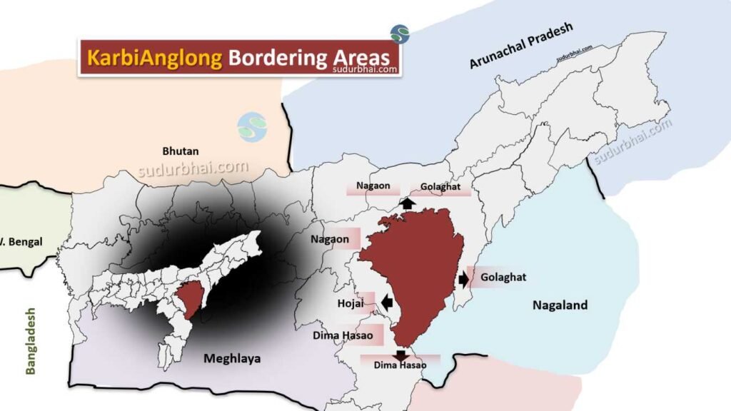
- North: Dima Hasao district.
- South: Meghalaya.
- East: Karimganj and Nagaon districts.
- West: Golaghat district.
- Topography: The landscape is dominated by Karbi Hills, with valleys and plains. The Laru Peak is the highest point at 1,290 meters.
- Rivers: Major rivers include Kopili, Amreng, Karbi Langpi, Amtereng, and Sinani.
- Climate:
- Winter: Temperatures range from 6°C to 12°C.
- Summer: Temperatures range from 23°C to 32°C.
- Rainfall: Average of 2,416 mm annually, mainly during the monsoon season.
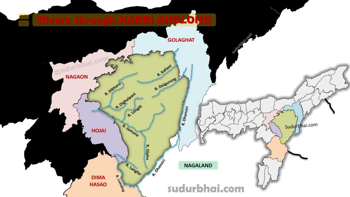
Socio-Economy of Karbi Anglong District
- Agriculture: The main source of livelihood. Crops include rice, maize, ginger, turmeric, and fruits.
- Livestock: Farming of cattle, goats, and poultry is common.
- Small-Scale Industries: Includes weaving, bamboo and cane products, and food processing.
- Tourism: The district has tourism potential due to its natural beauty and cultural heritage.
Transport in Karbi Anglong District
- Roadways: The district is connected by National Highway 39, linking it to other parts of Assam.
- Railways: The nearest stations are in nearby districts, with plans for expanding rail connectivity.
- Airways: The closest airport is in Dimapur (Nagaland), 70 km from Diphu (district headquarters).
Demographics of Karbi Anglong District
- Total Population: 956,313
- Males: 490,167
- Females: 466,146
- Decadal Growth (2001-2011): 17.58%
- Rural Population: 88.19%
- Urban Population: 11.81%
- Sex Ratio: 951 females per 1000 males
- Rural: 953 females per 1000 males
- Urban: 940 females per 1000 males
- Child Sex Ratio (0-6 years): 959 girls per 1000 boys
- Children (0-6 years): 16% of the total population
- Density: 92 people per square kilometer
Literacy (2011 Census):
- Total Literacy Rate: 69.25%
- Male Literacy Rate: 64.11%
- Female Literacy Rate: 52.12%
- Rural Literacy Rate: 66.69%3
- Male Literacy Rate (Rural): 73.95%
- Female Literacy Rate (Rural): 59.05%
- Urban Literacy Rate: 87.4%
Caste & Religion (2011 Census):
- Scheduled Castes (SC): 4.7% of the total population
- Scheduled Tribes (ST): 56.3% of the total population
- Religion:
- Hinduism: 80.10% or 80.36%
- Christianity: 16.50% or 15.32%
- Islam: 2.12% or 2.88%
- Buddhism: 0.65% or 0.87%
- Other or not stated: 1.00%
- Total Population: 956,313
Administrative Setup of Karbi Anglong District
- District Headquarters: Diphu.
- Autonomous Council: The Karbi Anglong Autonomous Council (KAAC) governs the district under the Sixth Schedule.
- Sub-Divisions: Includes Diphu and Bokajan.
- Development Blocks: Includes Howraghat, Bokajan, and others.
Rainfall in Karbi Anglong District
- Average Annual Rainfall: 2,000 mm to 2,500 mm, with most precipitation during the monsoon season (June to September).
- Flooding Risk: Heavy rainfall can lead to flooding, but it also enhances soil fertility.
Tourist Places in Karbi Anglong District
- Garampani: A sanctuary within the Nambor Reserve Forest that features a hot water spring near the national highway
- Khanduli: A village near the Assam-Meghalaya border known for its landscapes, indigenous cattle breeding, and traditional farming
- Koko Falls: A popular waterfall to visit
- Kokatheikhun Waterfall: Known for its cascading waterfalls and dense forests. It is ideal for nature lovers, trekkers, and photography enthusiasts
- Longkam Ronghangpi Cave: This natural cave offers a spelunking experience with interesting rock formations, stalactites, and stalagmites.
- Paklongkam Waterfalls: Located near the Bhelughat region, these waterfalls are surrounded by lush greenery and cliffs, with a natural pool at the base
- Umwang: An enchanting grassland on top of a table mountain surrounded by a large river, offering small trekking paths
Languages Spoken in Karbi Anglong District
- Karbi/Mikir: 45.72%
- Bengali: 10.82%
- Assamese: 7.63%
- Nepali: 5.38%
- Bhojpuri: 4.70%
- Bodo/Boro: 4.50%
- Hindi: 3.54%
- Garo: 2.61%
- Dimasa: 2.28%
- Lalung: 1.80%
- Sadan/Sadri: 1.32%
- Kuki: 0.96%
- Khasi: 0.81%
- Odia: 0.51%
Let us know any further suggestions ,we at sudurbhai.com will be happy to hear from you in our comment section below !