Kamrup District

District Overview: Kamrup District

    • Location: Central part of Assam, India.
    • Formed: In 2003 after being bifurcated from the undivided Kamrup district, creating Kamrup Metropolitan district.
    • Significance: Known for its rich cultural heritage, historical importance, and agricultural productivity.

History of Kamrup 

1. Ancient Kamrup (350–1140 CE)

    • Rulers: The region was ruled by three major dynasties: Varman (350–650 CE), Mlechchha (650–900 CE), and Pala (900–1140 CE).

    • Capitals:

      • The Varman dynasty established its capital at Pragjyotishpura (modern Guwahati).

      • The Pala rulers later shifted the capital to Durjaya (near present-day North Guwahati).

    • Identity: Kings referred to themselves as “Pragjyotishadhipati” (Rulers of Pragjyotisha) rather than Kamrupa, indicating an older identity associated with the region.

2. Medieval Kamrup (1250–1820 CE)

    • Kamata Kingdom (1250–1581): After the decline of the Pala dynasty, the region lost unified rule and became known as Kamata-Kamrup under local rulers.

    • Koch Hajo (1581–1612):

      • Viswa Singha, the founder of the Koch dynasty, established rule over the Baro-Bhuyan chieftains, unifying much of Kamrup.

      • The region became part of the Koch Kingdom, later divided between Koch Bihar (western part) and Koch Hajo (eastern part, including Kamrup).

    • Sarkar Kamrup (1612–1682):

      • The Mughals invaded Assam and established administrative divisions called Sarkars. Kamrup was one of four Sarkars and was renamed Shujabad.

      • However, the Ahoms defeated the Mughals in 1682 at the Battle of Itakhuli, reclaiming Kamrup.

    • Borphukan’s Domain (1682–1820):

      • Under Ahom rule, Sarkar Kamrup became the domain of the Borphukan, the Ahom viceroy, based in Guwahati.

    • Burmese Rule (1821–1824):

      • The Burmese empire occupied Assam, including Kamrup, during their invasions, leading to widespread devastation.

3. Colonial Kamrup (1833–1947 CE)

    • British Annexation (1824–1833):

      • Following the Anglo-Burmese War (1824–1826), the British took control of Assam.

      • In 1833, the Kamrup district was formally established by the British, largely following the boundaries of the Mughal Sarkar Kamrup of 1639.

      • The British introduced administrative and revenue reforms, significantly impacting the region’s economy and governance.

4. Modern Kamrup (Post-1947)

    • Post-Independence (1947–Present):

      • After India’s independence in 1947, Kamrup district continued to exist in its British-era form.

      • However, due to administrative reorganization, the district was gradually divided from 1983 onwards, forming multiple smaller districts.

      • The term “Undivided Kamrup District” is often used to refer to its original pre-division boundaries.

    • Economic and Industrial Growth:

      • In 1907, the Kamrup Industrial & Trading Company Limited was established in Guwahati, marking the beginning of Assam’s industrial growth. It was the first indigenous joint-stock company in Assam.

    • South Kamrup:

      • The southern bank of the Brahmaputra River in Kamrup district is referred to as South Kamrup, a region known for its agricultural and cultural significance.


Geography of Kamrup District

    • Area: 4,345 square kilometers.
    • Coordinates: Approximately 26°28′ N latitude and 91°38′ E longitude.
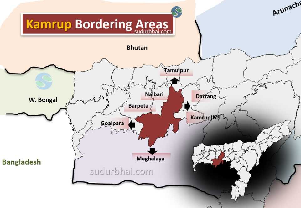
    • Boundaries:
      • North: Brahmaputra River, Darrang, and Sonitpur districts.
      • South: Meghalaya.
      • East: Karbi Anglong district.
      • West: Baksa and Barpeta districts.
    • Topography: Mix of flat plains and hilly terrains. The Brahmaputra River flows through the district, contributing to fertile land.
    • Climate: Humid subtropical with 2,500 mm average annual rainfall (mainly during the monsoon season from June to September).
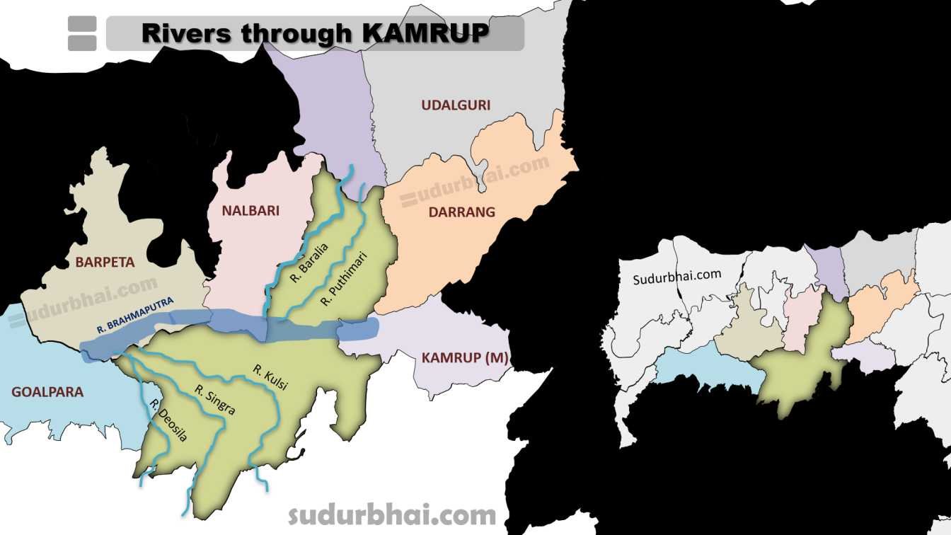
Socio-Economy of Kamrup District

    • Economy: Primarily agrarian, with agriculture as the main source of livelihood.
    • Major Crops: Rice, jute, mustard, tea, and various fruits. Jute production is particularly important.
    • Livestock Farming: Includes cattle, goats, and poultry.
    • Small-scale Industries: Handicrafts, bamboo products, and food processing.
    • Tourism Potential: The district has various archaeological sites and natural attractions.

Transport in Kamrup District

    • Roadways: Well-connected via National Highway 27, linking Kamrup to major cities.
    • Railways: Nearby railway stations in Guwahati and Rangiya offer connectivity to other parts of Assam and beyond.
    • Airways: Lokpriya Gopinath Bordoloi International Airport (in Guwahati) connects Kamrup to major cities in India.

Demographics of Kamrup District

    • Population: 1,517,542
      • Male: 778,461
      • Female: 739,081
    • Sex Ratio: 949 females per 1000 males
      • Rural: 947 females per 1000 males
      • Urban: 969 females per 1000 males
    • Child Sex Ratio (0-6 years): 967 girls per 1000 boys
    • Child Population (0-6 years): 13.18% of total population
    • Urban Population: 9.38% of total population
    • Rural Population: 90.62% of total population
    • Literacy Rate: 75.55%
      • Male: 81.30%
      • Female: 69.47%
      • Urban: 87.89%
      • Rural: 74.21%
    • Language Spoken:
      • Assamese: 74.43%
      • Bengali: 19.90%
      • Garo: 1.86%
      • Boro: 1.41%
      • Hindi: 1.17%
    • Scheduled Castes: 7.11% of the population
    • Scheduled Tribes: 12.00% of the population
    • Population Growth Rate (2001-2011): 15.67%

Administrative Setup of Kamrup District

    • Sub-Divisions: Includes Rangia and Boko.
    • Revenue Circles: Twelve revenue circles in the district.
    • Development Blocks: Multiple development blocks focused on local governance and development.
    • Administrative Headquarters: Located at Amingaon.

Rainfall in Kamrup District

    • Average Annual Rainfall: Around 2,000 mm to 3,000 mm, mostly during the monsoon.
    • Heavy rainfall can cause flooding in low-lying areas, but it also enriches the soil, benefiting agriculture.

Attractive Tourist Places

    • Hajo: A historical and pilgrimage site with temples significant to Hindus and Buddhists.
    • Kamakhya Temple: Famous Shakti Peeth on Nilachal Hill in Guwahati, dedicated to Goddess Kamakhya.
    • Sualkuchi: Known as the “Manchester of Assam,” famous for its silk weaving industry.
    • Other religious sites like Poa Mecca and Hayagriva Madhava Temple attract visitors for their cultural and religious significance.

Languages Spoken in Kamrup District

    • Assamese: 74.43%
    • Bengali: 19.90%
    • Garo: 1.86%
    • Boro: 1.41%
    • Hindi: 1.17%

Let us know any further suggestions ,we at sudurbhai.com will be happy to hear from you in our comment section below ! 

Leave a Comment

Your email address will not be published. Required fields are marked *

Scroll to Top