District Overview: Jorhat District
- Location: In the northeastern state of Assam, India.
- Established: 1983.
- Significance: Known as the “Cultural Capital of Assam” with a rich cultural heritage, agriculture, and historical importance.
History of Jorhat
1. Early History & Ahom Rule
Chutiya Kingdom (Before 16th Century):
Jorhat was originally part of the Chutiya Kingdom, an important kingdom in Assam.
The Ahoms defeated the Chutiyas in the 16th century, bringing Jorhat under their rule.
Ahom Capital Shift (1794):
King Gaurinath Singha of the Ahom dynasty moved the capital from Sibsagar to Jorhat.
Jorhat became a political and commercial hub, with new roads, tanks (ponds), and markets.
The city flourished under Ahom rule, attracting traders and settlers.
2. Burmese Invasions & British Rule
Burmese Invasions (1817–1825):
Jorhat was repeatedly attacked and destroyed by the Burmese army.
The local population suffered, and the once-thriving city was in ruins.
In 1825, the British defeated the Burmese and took control of Jorhat.
British Administration & Revolts (1858):
Under British rule, Jorhat saw new administration and infrastructure development.
Local revolutionaries like Piyali Phukan, Gomdhar Konwar, and Jeuram Medhi resisted British rule.
During the 1858 Sepoy Mutiny, Maniram Dewan and Piyali Phukan were publicly executed for opposing the British.
This period shaped Jorhat’s historical significance, from being a powerful Ahom capital to a center of resistance against British rule.
Geography of Jorhat District
- Area: 2,851 square kilometers.
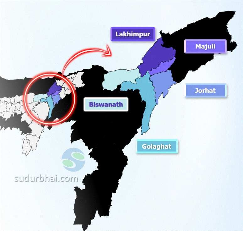
- Coordinates: Approximately 26°45′ N latitude and 94°13′ E longitude.
- Boundaries:
- North: Majuli district and bordering Brahmaputra River.
- South: Nagaland.
- East: Sivasagar district.
- West: Golaghat district.
- Topography: Mainly flat plains with some hilly areas, and fertile alluvial soil along the Brahmaputra River that supports agriculture.
- Rivers : Brahmaputra, Bhogdoi, Kakodonga, Jhanji, Teok.
- Climate: Humid subtropical with 1,867 mm of annual rainfall (mostly during the monsoon, June to September).
Socio-Economy of Jorhat District
- Economy: Primarily agrarian, with tea production being a major industry.
- Major Crops: Rice, tea, jute, mustard, and various fruits.
- Jorhat is a significant center for tea cultivation, home to Tocklai Experimental Station (a major tea research center).
- Livestock: Includes cattle, goats, and poultry.
- Small-scale Industries: Includes handicrafts, particularly bamboo and cane products.
- Tourism: Jorhat has potential for tourism, with archaeological sites and natural attractions.
Transport in Jorhat District
- Roadways: The district is well-connected via National Highway 37, linking it to major cities.
- Railways: The Jorhat railway station provides connectivity within Assam and beyond.
- Airways: Rowriah Airport (Jorhat Airport) connects the district to Guwahati and other cities.
Demographics of Jorhat District
Population Statistics
Total Population: 1,092,256
Male Population: 556,805 (50.93%)
Female Population: 535,451 (49.07%)
Population Density: 383 inhabitants per square kilometer
Urban Population: 220,534 (20.17%)
Rural Population: 871,722 (79.83%)
Sex Ratio
Overall Sex Ratio: 956 females per 1000 males
Urban Sex Ratio: 963 females per 1000 males
Rural Sex Ratio: 968 females per 1000 males
Literacy Rate
Overall Literacy Rate: 83.42%
Male Literacy Rate: 86.24%
Female Literacy Rate: 80.01%
Age Distribution
Children (0-6 years): 103,394 (9.45% of total population)
Child Sex Ratio: 968 girls per 1000 boys
Scheduled Castes and Scheduled Tribes
Scheduled Castes (SC): 64,787 (7.00%)
- Scheduled Tribes (ST): 62,368 (6.74%)
Religious CompositionReligion
Percentage
Hinduism
91.09%
Islam
5.85%
Christianity
2.25%
Other/Not Stated
0.81%
- Ethnic Composition: Mainly Assamese communities, including Tea tribes (Adivasi), Ahom, Chutia, Sonowal Kacharis, and Thengal Kachari.
Administrative Setup of Jorhat District
- Sub-Divisions: Two sub-divisions – Jorhat and Majuli.
- Revenue Circles: Five revenue circles – Jorhat, Teok, Golaghat, Majuli, and Mariani.
- Development Blocks: Six blocks – Jorhat, Teok, Golaghat, Majuli (partially), Mariani (partially), and Bhogdoi.
- Administrative Headquarters: Located in Jorhat city.
Rainfall in Jorhat District
- Average Annual Rainfall: Between 1,800 mm to 2,200 mm.
- Rainfall mainly occurs during the monsoon season (June to September), helping agriculture thrive in the region.
Attractive Tourist Places
- Historical and Cultural Sites:
- Thengal Bhavan Built in 1880, this historical mansion belonged to Assamese writer Rai Bahadur Siva Prasad Barooah and now serves as a heritage site
- Lachit Borphukan’s Maidam Constructed to honor Lachit Barophukan, who defeated the Mughal army in 1672
- Burigosain Devalay An ancient temple dedicated to the goddess Burigosain, an incarnation of the goddess Kali
- Hatibaruah Namghar A significant religious and cultural center and historical temple
- Gazpur An ancient historical site near Jorhat, famous for its archaeological remains and ancient temples
- Bangalpukhari A historic water tank believed to have been created during the reign of the Ahom king, Swargadeo Rudra Singha
- Ladai Garh A historical fort known for its strategic importance during the Ahom rule
- Raja Maidam A historical landmark
- Sukapha Samannay Kshetra Another historical site/memorial to visit
- Dhekiakhowa Bornamghar Jorhat A religious site
- Hoollongapar Gibbon Sanctuary A wildlife sanctuary
- Molai Forest A man-made forest on Majuli Island, home to diverse flora and fauna
- Majuli Island The world’s largest river island, also a center of neo-Vaishnavite pilgrimage
- Kakochange Waterfall Known for its scenic beauty
- Kaziranga National Park Features diverse animal life, including one-horned rhinoceroses, tigers, bisons, and elephants
- Historical and Cultural Sites:
Languages Spoken in Jorhat District
- Assamese: 88.65%
- Bengali: 3.77%
- Hindi: 3.04%
- Mising: 1.63%
Let us know any further suggestions ,we at sudurbhai.com will be happy to hear from you in our comment section below !