
Glaciers
- A glacier is a massive body of ice that forms on land and moves very slowly over time. The word “glacier” comes from the French word glace, meaning ice. Because they flow gradually, glaciers are often described as “rivers of ice.”
- Although glaciers are solid, they behave like a very slow-moving fluid due to the immense pressure of accumulated snow above them. Over time, layers of snow compress into ice, and gravity causes this ice mass to move downhill.
- Key features of glacier movement:
- Glaciers usually have a tongue-like shape, wider at the top and narrower as they move downhill
- The center of the glacier moves faster because there is less friction
- The sides and bottom move more slowly due to contact with valley walls and the ground
- If markers are placed across a glacier, they eventually form a curved pattern, proving faster movement at the center
- Even in places where glaciers no longer exist, the land may still show evidence of past glacial activity, known as glacial landforms.
- Glaciers fall into two groups: alpine glaciers and ice sheets
Alpine glaciers
- Alpine glaciers form in mountain regions and move downward through valleys under the influence of gravity.
- Important points about alpine glaciers:
- They flow through valleys, shaping and modifying them over time
- As they move, they push and carry rocks, soil, and debris, deepening the valleys
- They are found on high mountains across most continents, except mainland Australia (though present in New Zealand)
- Examples include:
- The Gorner Glacier in Switzerland
- The Furtwängler Glacier in Tanzania
- These glaciers are also known as valley glaciers or mountain glaciers because of their location.
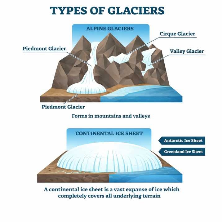
Types of glaciers
Ice sheets
- Ice sheets are much larger than alpine glaciers and are not confined to mountains. They form vast, dome-shaped masses of ice that spread outward in all directions.
- Key characteristics:
- They cover large areas of land, including plains, valleys, and even mountains
- The largest types, called continental glaciers, exist today in:
- Antarctica
- Greenland
- During the Pleistocene Ice Age, huge ice sheets covered large parts of North America and Europe. At their peak around 18,000 years ago, they reshaped the Earth’s surface by eroding and depositing materials.
Comparison of glacier types:
| Feature | Alpine Glaciers | Ice Sheets |
|---|---|---|
| Location | Mountain regions | Large continental areas |
| Size | Smaller | Extremely large |
| Movement | Along valleys | Spreads in all directions |
| Coverage | Limited | Covers vast regions |
The Ice-Age and Ice masses
- An ice age is a long period during which Earth’s temperature decreases significantly, leading to the formation and expansion of glaciers and ice sheets.
- Key concepts explained simply:
- Earth naturally shifts between cold periods (ice ages) and warmer periods
- We are currently in a phase known as the Quaternary glaciation
- Today, major ice caps exist mainly in:
- Antarctica
- Greenland
- Important processes:
- Ice from central ice caps flows outward to form glaciers
- When glaciers reach the ocean, they may form floating ice shelves
- Large pieces that break off are called icebergs
- Interesting fact:
- Only about one-ninth of an iceberg is visible above water, the rest remains submerged
- As icebergs drift into warmer waters:
- They melt gradually
- They release rocks and debris onto the ocean floor
- Formation of glacier ice:
- Snow accumulates in winter and does not fully melt in summer
- Melted snow refreezes repeatedly, forming a dense, granular substance called firn (or neve)
- Over time, this transforms into solid ice and begins to flow downhill under gravity, forming a glacier
Glacial Cycle of Erosion
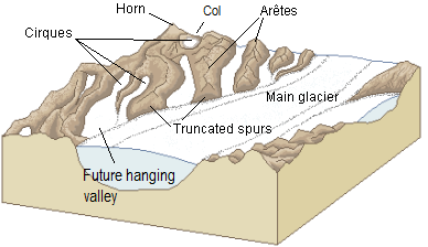
Youth:
- In the early stage, glaciers actively cut into mountain slopes, forming bowl-shaped depressions called cirques. Features like arêtes (sharp ridges) and horns (pointed peaks) begin to develop, but hanging valleys are not yet well formed.
Maturity:
- At this stage:
- Smaller glaciers merge into a main trunk glacier
- Hanging valleys start to appear
- Cirques on opposite sides grow closer
- The valley develops a more uniform and stepped profile
Old Age:
- This stage is marked by:
- Formation of U-shaped valleys with wide floors and steep sides
- Development of depositional features such as drumlins and outwash plains
- Reduction in mountain height as peaks become rounded and smooth
Glacial Landforms
- Glaciation creates two main types of landforms:
- Erosional landforms in highland areas
- Depositional landforms in lowland areas
- Glaciers shape the land mainly through two processes:
- Plucking: Ice freezes onto rocks, pulls them out, and carries them away
- Abrasion: Rocks embedded in ice scrape and polish the surface beneath
Glacial Landforms – Erosional
Snout or Glacier terminus
- The snout (or terminus) is the end point of a glacier. It is usually the lowest part and changes position depending on whether the glacier is advancing or retreating.
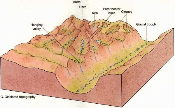
Corrie, Cirque or cwm
- A cirque is a bowl-shaped hollow formed at the head of a glacier due to intense erosion.
- It has steep sides and a rounded base
- When filled with water after ice melts, it forms a tarn (corrie lake)
- Plucking & abrasion further deepen the depression into a steep horse shoe-shaped basin called Cirque (in French), cwm (in wales) & Corrie (in Scotland)
Cols
- Cols are low points or passes formed between two cirques on opposite sides of a mountain.
Horns
- Horns are sharp, pyramid-shaped peaks formed when several cirques erode a mountain from different sides.
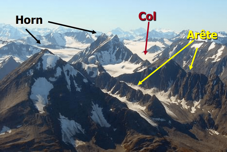
Aretes and Pyramidal Peaks
- Arêtes are narrow, knife-edged ridges formed between two cirques
- When multiple cirques erode a peak, they form a pyramidal peak (horn)
Bergschrund
- A bergschrund is a deep crack that forms near the top of a glacier where moving ice separates from stationary ice.
- It becomes prominent in summer
- It can be dangerous for climbers
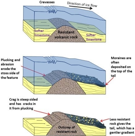
Roche moutonnée
- This is a smooth, rounded rock formation shaped by glacier movement.
- The front side is smooth due to abrasion
- The back side is rough and steep due to plucking
Crag and tail
- A crag and tail consists of:
- A hard rock mass (crag) that resists erosion
- A gentle slope (tail) formed by deposited material behind it
Nunatak
- A nunatak is a mountain peak that sticks out above a glacier or ice sheet, appearing like an island in a sea of ice.
Paternoster Lakes
- These are a series of small lakes connected by a stream, formed in glacial valleys due to uneven erosion and deposition.
U shaped glacial Troughs & Ribbon lakes
- Glaciers transform V-shaped river valleys into U-shaped valleys:
- Wide, flat floors
- Steep sides
- After glaciers melt, water may fill deeper sections to form ribbon lakes, which are long and narrow.
Hanging Valleys
- Smaller valleys that join a main valley are left suspended above it after glacier melting.
- Water falls from these as waterfalls
- They can be useful for hydropower generation
Rock Basins and Rock Steps
- Irregular erosion creates:
- Rock basins, which later fill with water
- Rock steps, formed due to uneven erosion
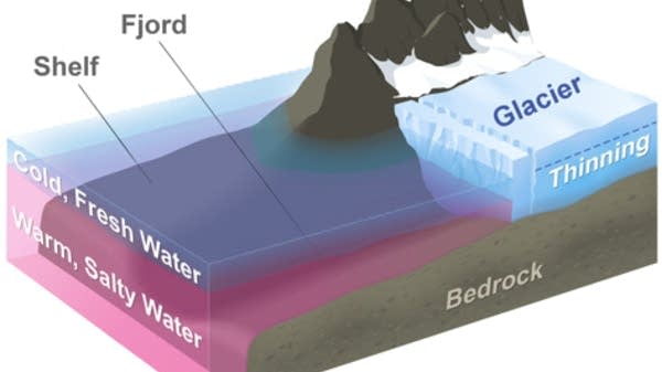
Fjord
- A fjord is a deep, narrow sea inlet formed when a glacial valley is submerged by seawater.
- Common in regions like Norway and Greenland
Glacial Landforms – Depositional
Boulder clay or Glacial till
- This is a mixture of materials deposited by glaciers, including:
- Large rocks (boulders)
- Clay
- Fine sediments
- It is unsorted and spreads across large areas, forming gently rolling plains.
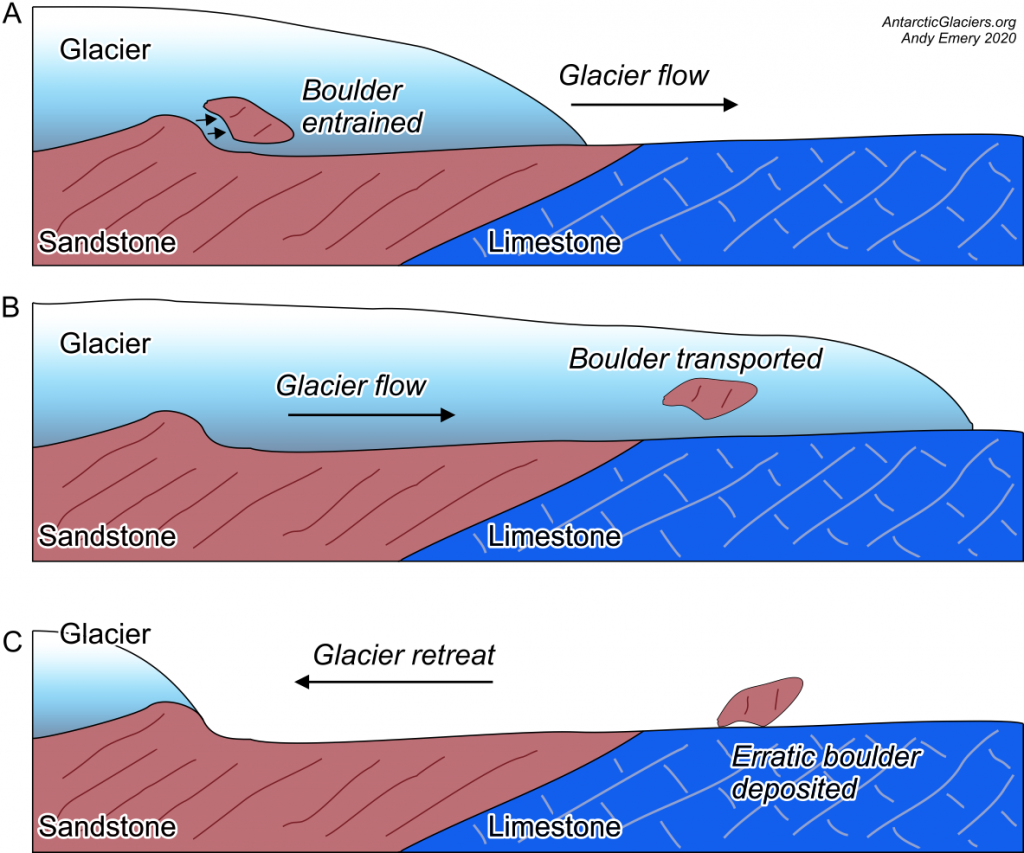
Erratics
- Erratics are large rocks transported by glaciers and deposited far from their original location.
- They help scientists trace glacier movement
- They may obstruct farming
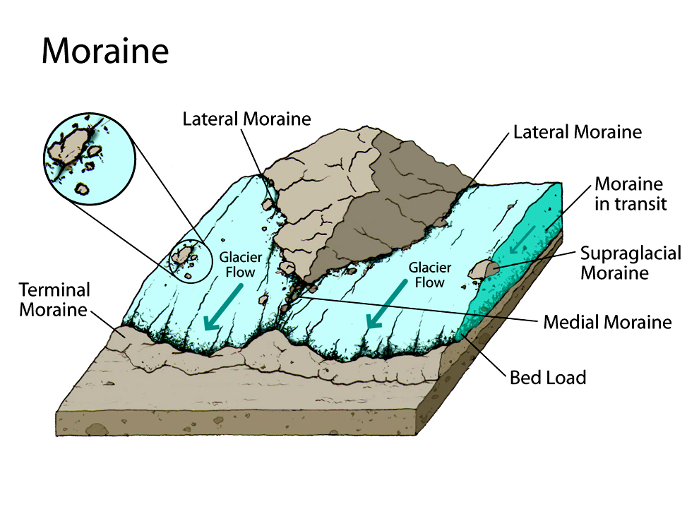
Moraines
- Moraines are accumulations of rock debris carried and deposited by glaciers.
- Types include:
- Lateral moraine: along glacier sides
- Medial moraine: formed when two glaciers meet
- Ground moraine: spread across valley floor
- Terminal moraine: deposited at the glacier’s end
Drumlins
- Drumlins are elongated hills formed beneath glaciers.
- They have a steep side facing the ice movement
- A gentle slope on the opposite side
- Often appear in groups, called drumlin fields
Eskers
- Eskers are long, winding ridges made of sand and gravel deposited by meltwater flowing under glaciers.
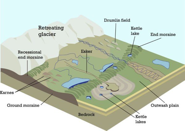
Kames
- Kames are small hills of sand and gravel formed by glacial deposits.
Outwash Plains
- These are flat areas formed by meltwater depositing sorted sediments like sand and silt.
- Often used for agriculture, especially crops like potatoes
Kettle lake
- Kettle lakes form when blocks of ice melt, leaving behind water-filled depressions.
Kames
- These are also known as hummocks, small rounded hills often found with kettle lakes, forming kame and kettle topography