Fluvial landforms
Fluvial landforms are features on the Earth’s surface created by the action of running water, mainly rivers. The word fluvial comes from the Latin term “fluvius”, which means river.
- These landforms range from very small features like tiny channels to large systems such as major rivers and their drainage basins
- Rivers flowing into oceans drain about 68% of the Earth’s land surface, making them a dominant force in shaping landscapes
- Origin of rivers
- Rivers usually begin in highland or mountainous areas where water flows downward due to gravity
- These highlands act as catchment areas, collecting rainwater
- The highest points (like mountain ridges) form divides or watersheds, separating different river systems
- Key terms explained:
- Consequent stream: The initial stream that forms naturally along the slope
- Tributaries: Smaller streams that join the main river
- Drainage basin: The entire area drained by a river and its tributaries
- Drainage basin as a system:
- Acts like a funnel, collecting water and directing it to a main river
- Includes both land surface and water channels
- Various aspects of fluvial erosive action include:
- Hydration
- The force of flowing water gradually weakens and breaks rocks
- Corrosion / Solution
- Chemical action dissolves minerals in rocks
- Attrition
- Rock fragments collide with each other, becoming smaller and smoother
- Corrasion (Abrasion)
- Rocks carried by water scrape against the river bed, causing erosion
- Downcutting (Vertical erosion)
- Deepens the river channel, forming valleys
- Lateral erosion
- Widens the river valley by eroding its sides
- Headward erosion
- Extends the river backward, increasing its length
- Hydraulic action
- Water enters cracks, loosens rock particles, and removes them
- Braiding
- A river splits into multiple channels, forming small islands called braid bars
- Common in rivers with high sediment load and gentle slopes
- Hydration
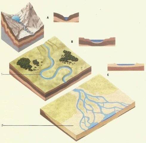
River course
Rivers pass through different stages during their journey, and each stage creates distinct landforms.
Youth
- Rivers flow over steep slopes with high speed
- Few streams exist, and they are poorly connected
- Valley features:
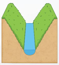
- Deep, narrow, V-shaped valleys
- Little or no floodplain
- Dominant process:
- Vertical erosion (downcutting)
- Common landforms created:
- Gorges and canyons
- Waterfalls and rapids
- River capture
Mature
- Rivers have many tributaries and are well connected
- Changes observed:
- Lateral erosion increases, replacing vertical erosion
- Valleys become wider and deeper
- Features:
- Development of floodplains
- Formation of meanders (bends in rivers)
- Other changes:
- Waterfalls and rapids gradually disappear
- Inter-stream areas become more defined
Old
- River flows over a broad, flat plain
- Carries a large amount of sediment
- Dominant process:
- Deposition becomes more important than erosion
- Characteristics:
- Extensive meandering
- Wide floodplains
- Very gentle slopes
- Common landforms:
- Oxbow lakes
- Natural levees
- Deltas
Fluvial Erosional Landforms
Fluvial Landforms (Erosional)
These landforms are created mainly by the erosive action of running water.
Splash Erosion
- Caused by the impact of raindrops on bare soil
- Raindrops act like tiny explosions, dislodging soil particles

Sheet Erosion
- Occurs when water flows as a thin layer over the surface
- Removes a uniform layer of soil
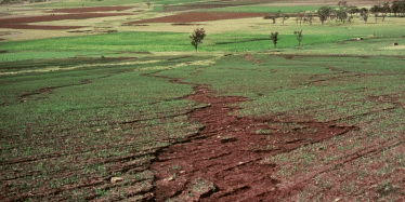
Rills, and Gully
- Rills: Small, shallow channels formed by flowing water
- Gullies: Larger channels that cannot be easily removed

Nala or Rivulet
- A rivulet is a small stream or minor water channel

Ravine
- A ravine is a deep, narrow landform, larger than a gully but smaller than a valley
- Formed mainly due to erosion along river banks

River Valleys
- A river valley is a long depression through which a river flows.
- Formation process:
- Starts as small rills
- Develops into gullies
- Eventually forms large valleys
- Types of valleys:
- V-shaped valleys
- Gorges
- Canyons
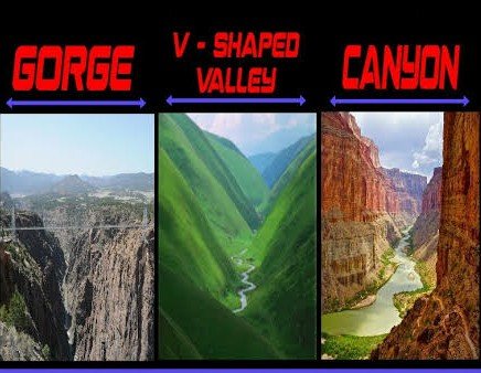
I-shaped valley/Gorge
- A gorge is a deep and narrow valley with steep sides
- It appears almost uniform in width from top to bottom
- Usually formed in hard rocks

Canyon
- A canyon is similar to a gorge but:
- Wider at the top
- Has step-like sides
- Common in horizontal sedimentary rocks

V-shape valley
- Formed by rapid downward erosion
- Characterized by steep slopes and narrow base
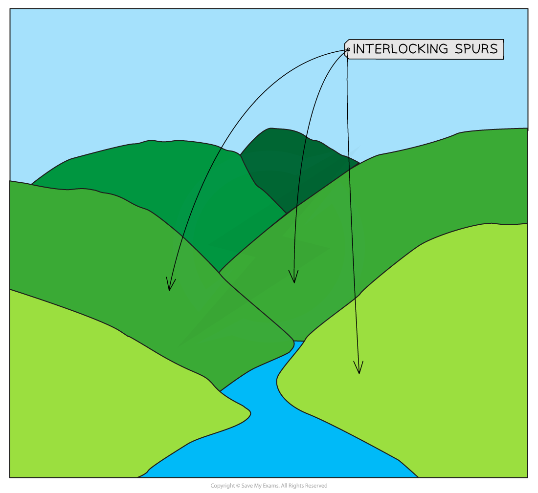
Interlocking spurs
- Alternating projections of land on either side of a valley
- Common in young river stages

Waterfalls & Rapid
- Waterfalls occur when water drops suddenly from a height
- Strong force creates a plunge pool at the base
- Rapids form where there is a sudden change in slope or rock resistance
- Important concept:
- Waterfalls gradually move backward (recede) over time

- Waterfalls gradually move backward (recede) over time
Potholes & Plunge Pool
- Potholes are circular depressions formed in river beds
- Created by rotating pebbles and stones
- Plunge pools are deep holes at the base of waterfalls
- Formed due to strong water impact

Cataract
- A cataract is a large and powerful waterfall
- When the slope is less steep, it is called a cascade
Ait/Eyot
- A small river island formed by sediment deposition
- Usually long and narrow
- Can grow with vegetation or erode over time
Incised or Entrenched Meanders
- Deep, winding river bends cut into hard rock
- Formation:
- Occur when rivers cut downward rapidly
- Original meanders become deeply embedded
- Significance:
- Indicate changes in land elevation or river energy

- Indicate changes in land elevation or river energy
Structural Benches
- Step-like landforms formed due to uneven erosion of hard and soft rocks
- Also known as terraces formed by rock structure differences

River Terraces
- Flat surfaces representing old river beds or floodplains
- Types:
- Rock terraces (without sediment cover)
- Alluvial terraces (with deposited materials)
- Found at different heights, showing previous river levels

Peneplain
- A nearly flat land surface formed after prolonged erosion
- Represents an advanced stage of landscape leveling
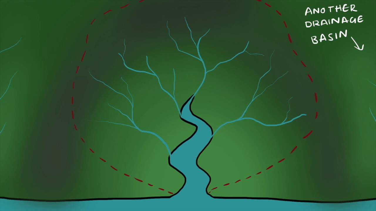
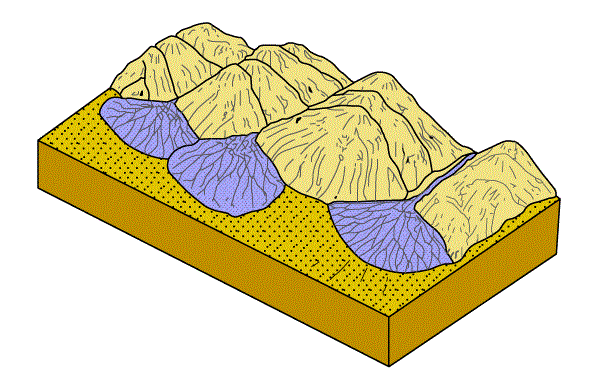
Drainage Basin
- Also called catchment area or river basin
- Includes all land and water contributing to a river
- Special case:
- In closed basins, water collects in a lake or disappears underground
Drainage Divide
- A high land or ridge separating two drainage basins
- Clearly visible in mountain regions, less distinct in plains
Drainage Patterns
- Drainage patterns refer to the arrangement of rivers and streams in an area. These patterns depend on:
- Slope of land
- Rock type and structure
- Geological conditions
- Major types of drainage patterns:
- Dendritic pattern
- Resembles tree branches
- Most common type
- Trellis pattern
- Parallel main streams with right-angle tributaries
- Found in folded mountains
- Parallel pattern
- Streams run parallel due to steep slopes
- Rectangular pattern
- Rivers follow right-angle bends due to rock joints
- Angular pattern
- Tributaries join at acute angles
- Radial pattern
- Rivers flow outward from a central high point (like a volcano)
- Centripetal pattern
- Rivers flow towards a central depression or lake
- Annular pattern
- Streams follow a circular path, forming ring-like patterns

- Streams follow a circular path, forming ring-like patterns
- Dendritic pattern
Fluvial Landforms (Depositional)
Fluvial depositional landforms are created by the accumulation of sediments carried by rivers. These sediments mainly originate from erosion in the upper (youthful) course of a river.
- In the upper course, rocks and slopes are continuously eroded
- As the river flows downstream onto gentle plains, its speed decreases
- This reduction in velocity lowers the river’s carrying capacity, leading to deposition of sediments
Important concept of deposition:
- Heavier and coarser materials are deposited first
- Finer particles (silt and clay) are carried further downstream
This process results in the formation of various landforms such as floodplains, deltas, levees, and more.
Alluvial Fans and Cones
- An alluvial fan is a cone-shaped deposit of sediments formed where a fast-flowing stream exits a mountainous region and enters a flat plain.
- Formation process:
- Streams carry large and coarse materials from steep slopes
- When they reach a gentler gradient, their speed decreases
- The heavy load is deposited, spreading outward in a fan-like shape
- Characteristics:
- Broad and gently sloping in humid regions
- Steeper and more pronounced in arid and semi-arid regions
- Often appear as a series of overlapping fans
Floodplains
- A floodplain is a wide, flat area adjacent to a river, formed mainly by deposition.
- How it forms:
- In the lower course, rivers carry large amounts of sediment
- During floods, water overflows the banks and spreads sediments across nearby land
- Repeated flooding deposits layers of silt and clay, gradually building the floodplain
- Key features:
- Channels may shift position over time
- Old channels may get filled with sediments
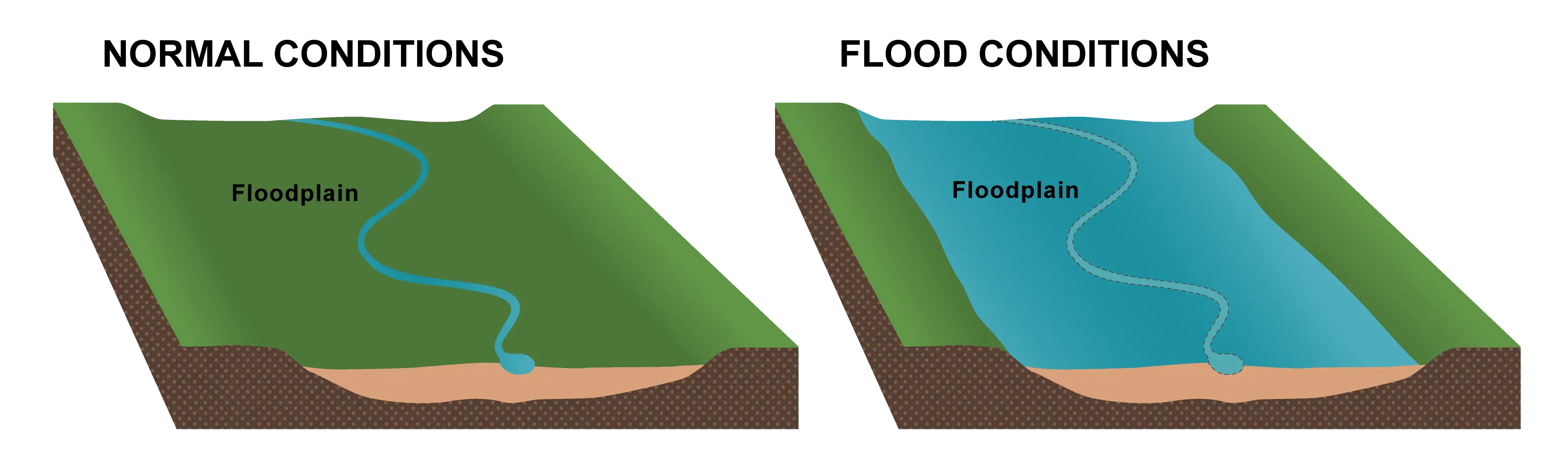
- Types of floodplains:
- Active floodplain
- The current riverbed area, regularly affected by floods
- Inactive floodplain
- Higher areas beyond the banks, flooded only occasionally
- Contains both channel deposits and flood deposits
- Delta plains
- Floodplains found in delta regions near river mouths
- Active floodplain
Doab
- A doab is a land area between two rivers.
- The term is widely used in South Asia (India and Pakistan)
- It refers to a fertile tract of land formed by river deposition

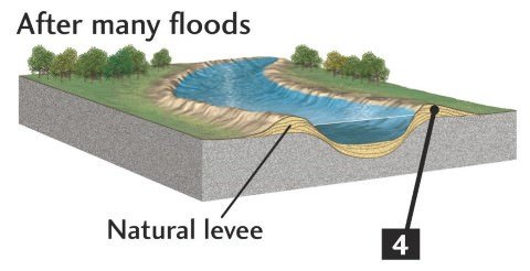
Natural Levees
- Natural levees are raised ridges of sediment formed along river banks.
- Formation process:
- During floods, water spills over the banks
- As velocity decreases, coarse sediments are deposited near the banks
- Over time, this forms elevated embankments
- Key characteristics:
- Higher near the river and slope gently outward
- Made mainly of coarse materials
- Important points:
- Rivers may form multiple levees due to shifting channels
- Artificial embankments are often built on levees to control floods
- However, sudden breaches can cause severe flooding
Point Bars & Cut Banks
- These features are associated with river bends (meanders).
- Point Bars (Depositional feature):
- Form on the inner (convex) side of bends
- Created by the accumulation of sediments (alluvium)
- Usually smooth and gently sloping
- Cut Banks (Erosional feature):
- Found on the outer (concave) side of bends
- Formed by erosion due to faster water flow
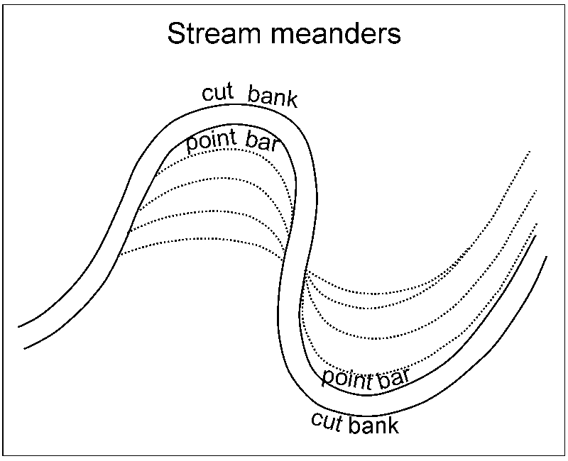
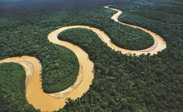
Meanders
- Meanders are loop-like bends in a river channel, commonly seen in plains.
- Formation:
- Caused by a combination of:
- Deposition on the inner bank
- Erosion on the outer bank
- Caused by a combination of:
- Key terms:
- Concave bank (cut bank) → steep and eroded
- Convex bank (slip-off slope) → gentle and depositional
Oxbow Lake
- An oxbow lake is a crescent-shaped water body formed from a cut-off meander.
- Formation steps:
- Meanders become more pronounced
- Erosion cuts through the narrow neck of the loop
- The loop is isolated from the main river
- Later changes:
- Gradually fills with sediments
- May turn into a marsh or swamp, and eventually dry up
Riffle and Pool
- Rivers often show alternating sections of riffles and pools.
- Pools
- Deep sections with slow-moving water
- Formed by strong downward erosion
- Provide calm water zones
- Riffles
- Shallow areas with fast, turbulent flow
- Created by rocks disturbing water flow
- Rich in oxygen and nutrients

Bluff
- A bluff is a steep slope or small cliff overlooking a river or water body.
- Represents a raised edge of land
- Often formed due to erosion and deposition processes

Braided Channels
- A braided channel consists of multiple interwoven river channels separated by small islands.
- Formation conditions:
- High sediment load
- Low water velocity
- Process:
- Coarse sediments form bars or islands
- These divide the river into several channels

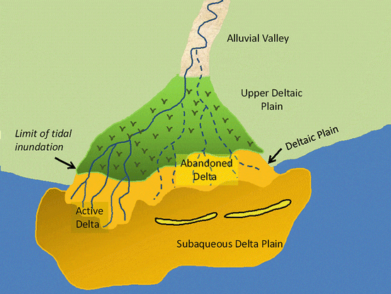
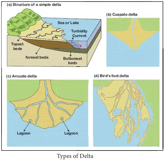
Delta
- A delta is a fan-shaped deposit of sediments at the mouth of a river where it enters a sea or ocean.
- Formation process:
- River slows down upon meeting the sea
- Deposits its sediment load
- Sediments spread outward and build up over time
- Key features:
- Well-sorted and layered sediments
- Expands both outward (seaward) and sideways
- River divides into distributaries
| Type of Delta | Description | Example |
|---|---|---|
| Bird’s Foot Delta | Long, finger-like distributaries resembling a bird’s foot | Mississippi River |
| Arcuate Delta | Fan-shaped with a curved outline | Nile, Ganges |
| Cuspate Delta | Pointed, tooth-like projection | Ebro River |
| Estuarine Delta | Partially submerged due to rising sea level | Amazon River |
Conditions favorable for the formation of delta
- For a delta to form effectively, certain conditions must be met:
- Abundant sediment supply from upper river erosion
- A calm and sheltered coastline
- Shallow sea near the river mouth
- Absence of large lakes that trap sediments upstream
- Lack of strong ocean currents that could wash away sediments