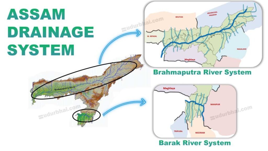
Drainage system refers to the network of rivers and their tributaries that drain water from the land into larger water bodies. In Assam, the drainage is dominated by :
A. The Brahmaputra system (in northern Assam)
B. The Barak system (in southern Assam).
Assam’s drainage plays a crucial role in shaping its physiography, ecology, agriculture, transport, economy, settlement and natural hazards.
- Assam has over 50 major tributaries joining these two master streams.
- Total length of all rivers in Assam: ~4,000 km ( Few rivers are navigable in parts)
- Drainage pattern: Largely dendritic in plains.
- Unique features: World’s largest river island (Majuli), extensive wetlands (beels), and chars/chaporis (riverine islands) formation.
Drainage Features & Patterns in Assam
| Feature | Details |
|---|---|
| Drainage Pattern | Mainly dendritic with antecedent nature for large rivers. |
| Channel Type | Braided (Brahmaputra), meandering (Barak). |
| Riverine Islands | Majuli (shrinking due to erosion), Umananda. |
| Floodplains & Beels | Extensive alluvial plains with wetlands (‘beels’). |
| Sediment Load | High from Himalayas, slows river flow, causes deposition. |
Major Drainage Systems of Assam
A. Brahmaputra River System
B. Barak River System
A. Brahmaputra River System
The Brahmaputra is the dominant drainage system of Assam. It is a transboundary Himalayan river with a huge catchment and sediment load.
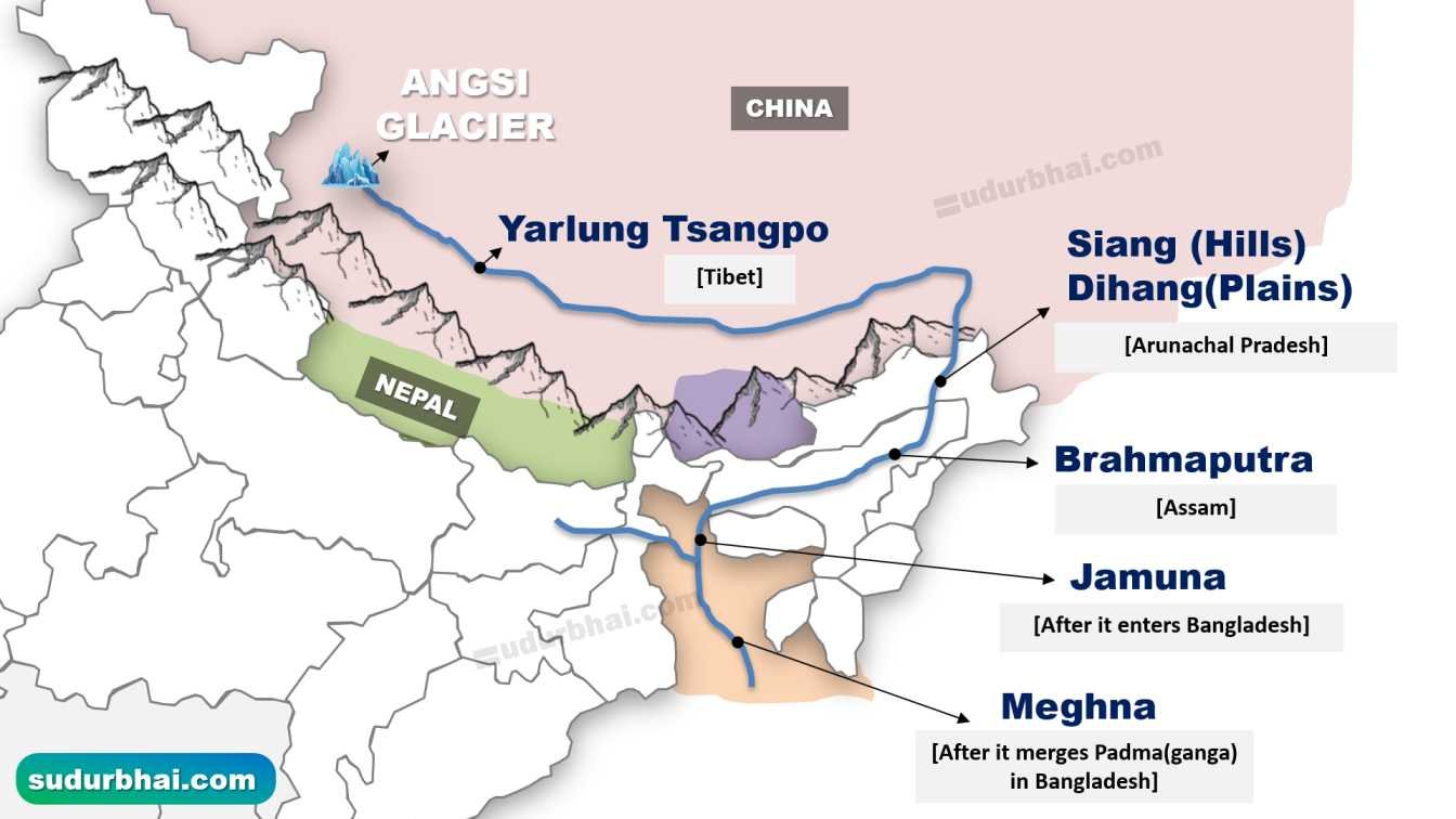
Origin & Course of Brahmaputra River
Origin: Chemayungdung/Angsi Glacier in the Kailash Range, Tibet (at an altitude of ~5,150–5,300 m).
Stage of River
Name of River
Location / Description
Upper Course (Tibet)
Yarlung Tsangpo / Tsangpo
In the Tibetan Plateau (china).
Flows along East.
Entry into India (Arunachal Pradesh)
Siang / Dihang
Called as Siang (in Hills)
Called as Dihang (in plains)
In Assam near Sadiya (Formation of Brahmaputra)
Brahmaputra proper
Near Sadiya in Assam, the Siang/Dihang is joined by the Lohit and Dibang . Then it becomes Brahmaputra .
Along the lower course
Jamuna
Meghna
As it enters Bangladesh
After it gets confluence with Padma (ganga)
- Locally, Brahmaputra is known locally as Luit
- Average width in Assam: 8-10 km (widest ~20 km near Dhubri).
- Flows ~640–700 km across Assam towards Dhubri, entering Bangladesh as the Jamuna; finally joins Padma (Ganga)–Meghna to reach the Bay of Bengal.
Season
Typical Depth of Brahmaputra River (in mts.)
Dry/Winter (Dec-Feb)
18-30 (avg. 30m max)
Pre-Monsoon/Summer (Mar-May)
20-38 (avg. 38m)
Monsoon (Jun-Oct)
27-135 (max 135m at Sadiya)
Post-Monsoon (Nov)
25-40
Key Characteristics of Brahmaputra River System
- Braided river system with shifting channels, multiple bars and islands.
- Majuli – world’s largest inhabited river island within Brahmaputra (Majuli area ~350 sq km)
- Maximum width varies from 5-16 km (seasonal).
- Carries high sediment load from the Himalayas.
- Prone to bank erosion and frequent floods.
- Average annual discharge: ~20,000 m³/s (dry season ~4,420) ; peaks >1,00,000 m³/s during floods.
- Slope: Gentle slope , leading to meandering and floods.
Physiographic Importance of Brahmaputra River System
Brahmaputra shapes the Assam Valley plain between the foothills and the hills to the south.
The braided channels and heavy sediment deposition frequently change river course and flood plains.
Major riverine islands like Majuli (world’s largest river island) and Umananda exist due to braiding.
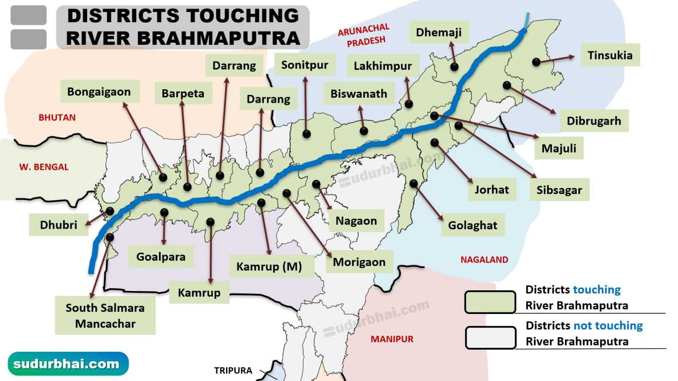
Major Tributaries of river Brahmaputra:
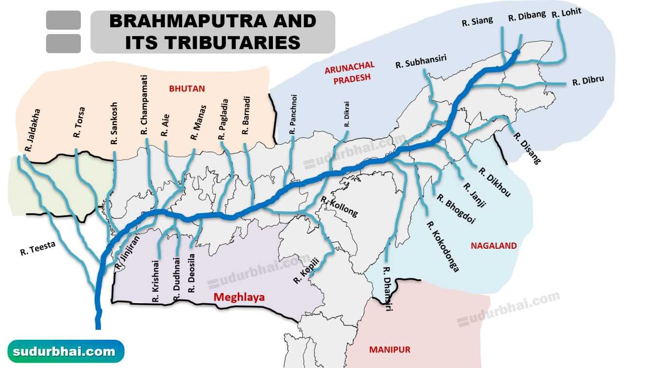
Brahmaputra touches the following districts : 21 Districts
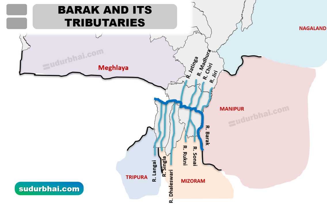
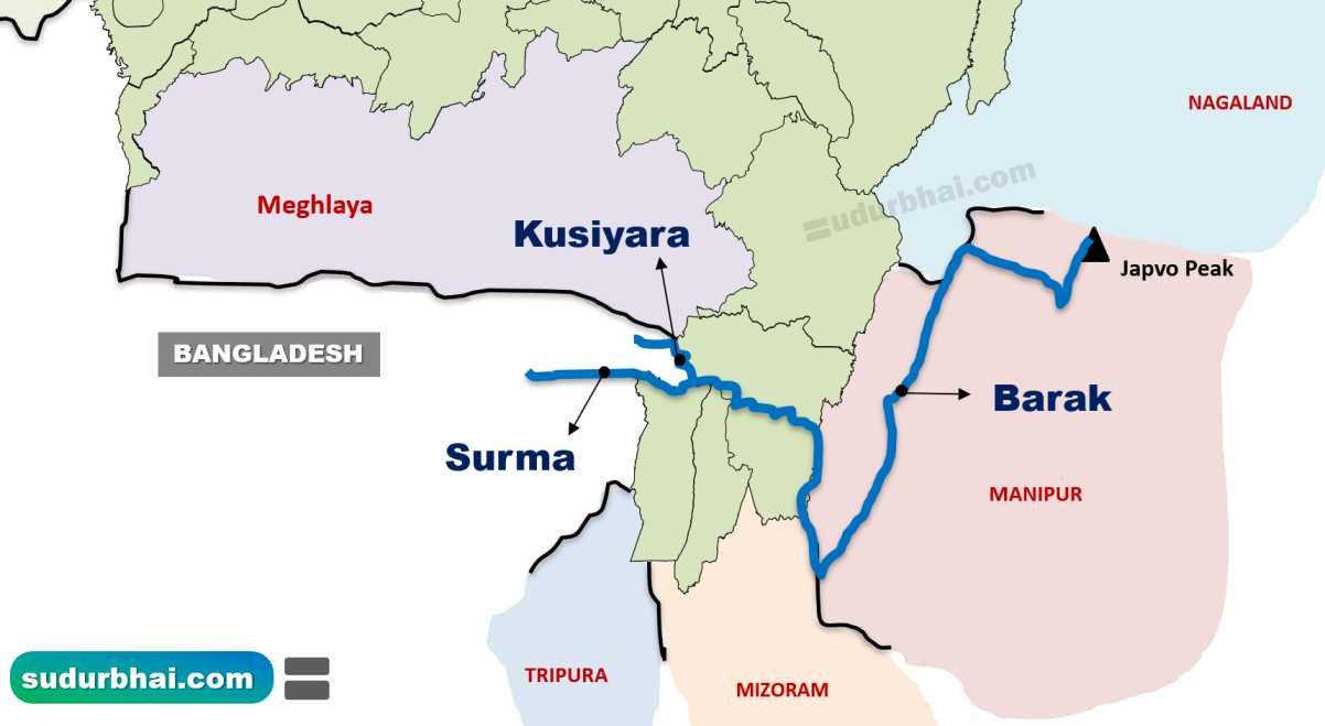
B. Barak River System
A separate drainage system of southern Assam (Barak Valley: Cachar, Hailakandi, Sribhumi). Unlike Brahmaputra, it does not join Brahmaputra within India.
Origin & Course of Barak River
Origin: Japvo Peak (at Manipur hills), flows west through Barak Valley.
- Enters Assam in Cachar district
Total length ~900 km (about 524 km within Assam).
It bifurcates into Surma and Kushiyara before entering Bangladesh.
It eventually merges with river Meghna in Bangladesh.
Features & Drainage of Barak River
- Less braided than Brahmaputra; more meandering with broad floodplains.
- Lower discharge but causes severe floods in Barak valley (reason -rainfall and runoff from adjacent hills).
- Supports irrigation in Cachar, Sribhumi and Hailakandi districts.
- Separate hydrological unit from Brahmaputra — with distinct cultural and ecological landscape.
Major Tributaries of Barak River
- Jiri, Chiri, Madhura (north bank).
- Sonai, Katakhal, Dhaleswari (south bank).