

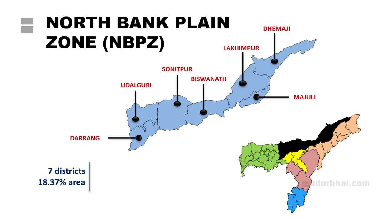
1. North Bank Plain Zone (NBPZ)
Location
Lies north of the Brahmaputra River (Hence, North Bank)
Includes 7 districts like Dhemaji, Lakhimpur,Majuli, Biswanath, Sonitpur, Udalguri and Darrang.
Covers 18.37% of state’s area
Climatic characteristics
Humid subtropical climate.
High Humidity (73–99%, peaking inmonsoon).
Annual rainfall: 2500–3000 mm (varies by district; e.g., Dhemaji 2600–3200 mm, Sonitpur ~2318 mm, Udalguri ~1972 mm).
Rainfall Distribution: Erratic pattern → pre-monsoon showers, intense monsoon (Heavy SW monsoon (June–September)), low post-monsoon/winter rain.
Temperature: Sub-tropical; hot humid summers (max 30–32°C), mild winters (min 10–15°C)
Frequent floods and riverbank erosion
Soil & Topography
Topography: Mostly plain/alluvial plains; foothills in north (gentle slopes), central old alluvium belt, low-lying riverine areas near Brahmaputra.
- Soils: Predominantly new and old alluvial (fertile); variations include:
- Clay and clay loam (high organic matter, good water/nutrient retention; medium N, P, K).
- Alluvial (medium fertility).
- Sandy loam/sandy in patches (low organic matter, low NPK).
- Soil fertility: Medium to high in lowlands; acidic tendencies in some areas; high C:N ratio in clayey soils.
- Issues: Flood-prone lowlands, erosion in foothills, sand casting post-floods.
Major Crops
- Dominant Crop: Paddy/rice (60–70% of cropped area); sali (winter rice) dominant; autumn (ahu), summer (boro) also grown.
- Other Field Crops: Jute, potato, pulses (black gram), oilseeds (rapeseed-mustard), maize.
- Horticulture: Wide potential due to diverse conditions; banana, Assam lemon, pineapple, citrus, vegetables, tuber crops, spices (ginger, turmeric, chilli, garlic), plantation crops (coconut, arecanut, betel vine).
- Allied Activities: Piggery, poultry, goat rearing, fishery, sericulture.
- Cropping Intensity: Moderate (e.g., ~144% in Dhemaji); mostly rainfed.
Major Farming Systems and Constraints
- Major Systems:
- Dominant – Rice-based (mono-cropping),
- Plains – rice + pulses/oilseeds,
- Uplands – horticulture + plantation ,
- Most common – integrated farming (crops + livestock + fishery).
- Constraints:
- Frequent flash floods (from Arunachal streams) and seasonal droughts.
- Erratic monsoon → 40% probability of adverse crop production.
- Low irrigation (~6–7% in some districts); high rainfed dependence.
- Resource-poor farmers; limited mechanization; shifting cultivation fringes.
- Pests/diseases (e.g., stem borer, leaf folder, blast in rice)
- Soil erosion – along riverbanks.
- Vulnerabilities: Climate change → increased flash floods, droughts; makes rainfed agriculture risky/unprofitable.
- Major Systems:
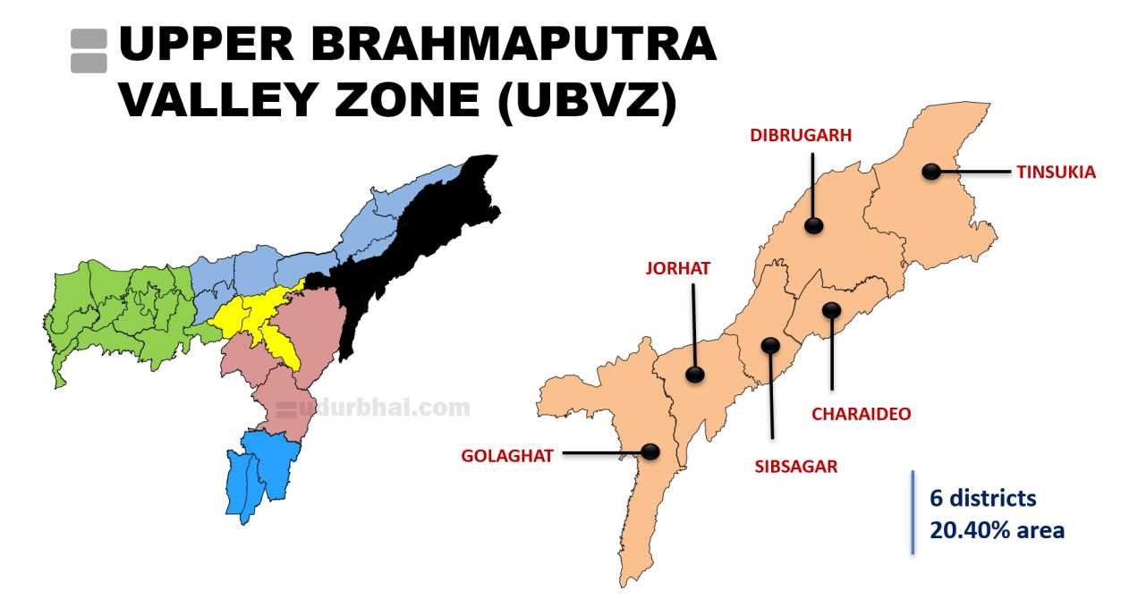
2. Upper Brahmaputra Valley Zone (UBVZ)
Location :
- Covers the upper (eastern) reaches of the Brahmaputra Valley (along the southern bank of river Brahmputra).
- 6 Districts: Golaghat, Jorhat, Sivasagar, Charaideo, Dibrugarh, Tinsukia.
- Covers 20.40% of state’s area
- Terrain: Mostly flat to moderately undulating alluvial plains; gentle slopes; some char (riverine) lands; tea garden uplands in foothills.
Climatic Characteristics
- Annual Rainfall: High; 2000–3500 mm (e.g., ~2400 mm in Charaideo/Sivasagar, 2600–3200 mm in parts of Dhemaji fringes, average ~2295–3000 mm across zone).
- Rainfall Distribution: Heavy SW monsoon (June–September); pre-monsoon showers; relatively lower post-monsoon/winter rain; erratic pattern in some years.
- Temperature: Sub-tropical humid; hot summers (max 30–35°C), mild winters (min 9–15°C).
- Relative Humidity: High (especially monsoon); supports lush vegetation and tea estates.
- Key Features: Flood-prone due to Brahmaputra and tributaries (e.g., Burhi Dihing, Dikhow); occasional flash floods; suitable for rainfed + irrigated cropping (mostly rainfed).
Soil Types and Topography
- Topography: Predominantly flat alluvial plains; moderately undulating in parts; char lands (river islands) with variable stability.
- Soils: Rich alluvial soils (new and old); highly fertile due to annual silt deposition; deep to moderately deep loamy to clay loam.
- Characteristics: High organic matter, nitrogen-rich; good phosphoric content; slightly acidic to neutral in uplands.
- Variations: Sandy loam in patches; red loamy in some elevated areas; laterite fringes.
- Soil fertility: Excellent for rice, tea, and plantation crops; flood replenishment enhances productivity.
- Issues: Soil acidity in tea estates (managed with lime); sand casting in chars; erosion in unstable riverine areas.
Major Crops and Cropping Patterns
- Dominant Crop: Paddy/rice (sali/winter rice major; also autumn/ahu and summer/boro); covers large area.
- Plantation Crops: Tea (world-famous Assam tea; major economic driver in Dibrugarh, Tinsukia, Jorhat, Sivasagar); arecanut, coconut, rubber in parts.
- Other Field Crops: Black gram (pulses), oilseeds (rapeseed-mustard), jute (limited), maize.
- Horticulture: Banana, orange, pineapple, papaya, vegetables; spices (ginger, turmeric, chilli).
- Cropping Intensity: Moderate to high in stable areas; rainfed dominant but irrigation supports boro rice.
- Special: Tea estates dominate landscape; integrated systems (tea + shade crops); potential for off-season vegetables.
Major Farming Systems and Constraints
- Major Systems: Rice-based mono-cropping; rice + pulses/oilseeds; tea plantation dominant; horticulture + plantation in uplands; integrated (crops + livestock + fishery in chars).
- Constraints:
- Annual flooding and river erosion (Brahmaputra chars unstable → low crop cultivation in large islands).
- High rainfed dependence; erratic monsoon affects rainfed planning.
- Pests/diseases in rice (blast, stem borer) and tea (red spider mite, blister blight).
- Soil management in acidic tea soils; low mechanization in smallholdings.
- Climate vulnerabilities: Increasing drought trends in some analyses; flood-drought alternation.
- Vulnerabilities: Most vulnerable to climate change among some zones (declining SPI/SPEI trends); flood risks high.
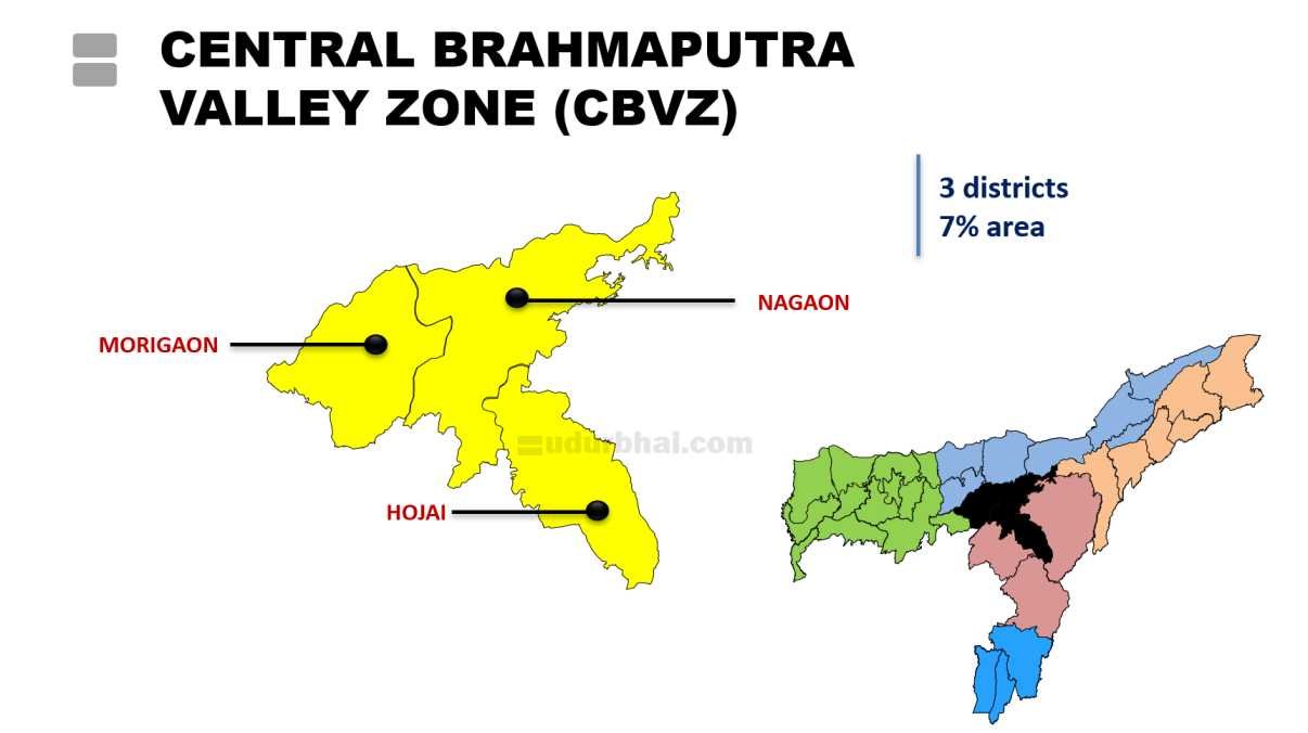
3. Central Brahmaputra Valley Zone (CBVZ)
Location :
- Covers the central plains of the Brahmaputra Valley.
- 3 Districts: Nagaon, Hojai, Morigaon.
- Covers 7% of state’s area
- Terrain: Vast plainlands dotted with fewer hilly terrains; alluvial floodplains; some char (riverine) areas; gentle slopes.
Climatic Characteristics
- Annual Rainfall: Moderate to moderate-high; ~1800–2500 mm (e.g., Nagaon ~1880 mm, Morigaon ~1245–1880 mm range; some sources average around 2000 mm).
- Rainfall Distribution: SW monsoon dominant (June–September); pre-monsoon showers; relatively balanced but with pockets of erratic patterns leading to occasional droughts in uplands.
- Temperature: Sub-tropical humid; hot summers (max 30–35°C), mild winters (min 10–20°C); supports double/triple cropping in irrigated areas.
- Relative Humidity: High during monsoon; conducive to rice and vegetable growth.
- Key Features: Lower drought risk ; flood-prone in lowlands but less severe than Lower Brahmaputra Valley; some rain-shadow effects in uplands.
Soil Types and Topography
- Topography: Mostly flat to gently undulating alluvial plains; vast open lands suitable for mechanization; fewer hills compared to northern/southern zones.
- Soils: Predominantly fertile alluvial (new and old); deep loamy to clay loam; high organic matter from Brahmaputra silt deposition.
- Characteristics: Good nutrient retention (medium to high N, P, K); slightly acidic in parts; excellent for rabi crops in floodplains.
- Variations: Clay loam dominant; sandy loam in patches; fertile char soils for pulses/oilseeds.
- Soil fertility: High; supports diverse cropping; annual flooding replenishes nutrients.
- Issues: Waterlogging in lowlands; soil erosion in unstable riverine areas; occasional sand casting post-floods.
Major Crops and Cropping Patterns
- Dominant Crop: Paddy/rice (sali/winter rice major; ahu/autumn and boro/summer also significant); covers large portion of cropped area.
- Other Field Crops: Pulses (black gram, green gram – major contribution to state’s pulses), oilseeds (rapeseed-mustard), jute, maize, sugarcane.
- Horticulture: Banana, papaya, pineapple, citrus, vegetables (winter vegetables prominent); spices (ginger, turmeric, chilli).
- Cropping Intensity: Moderate to high; potential for rabi/summer intensification due to fertile soils and irrigation scope.
- Special: Pulse production significant; opportunities for fallow season utilization (e.g., rabi crops post-kharif rice); millet trends in some studies.
Major Farming Systems and Constraints
- Major Systems: Rice-based (mono-cropping common); rice + pulses/oilseeds (rabi); integrated systems (crops + livestock + fishery); horticulture in uplands.
- Constraints:
- Floods in lowlands + seasonal droughts in uplands (erratic rainfall).
- Low irrigation coverage in rainfed areas; dependence on monsoon.
- Pests/diseases in rice and pulses; storage issues for pulses.
- Resource limitations for small farmers; low mechanization.
- Climate change: Alternating flood-drought; moderate vulnerability but lower than UBV/NBP.
- Vulnerabilities: Erratic monsoon impacts rainfed productivity; need for better moisture management.
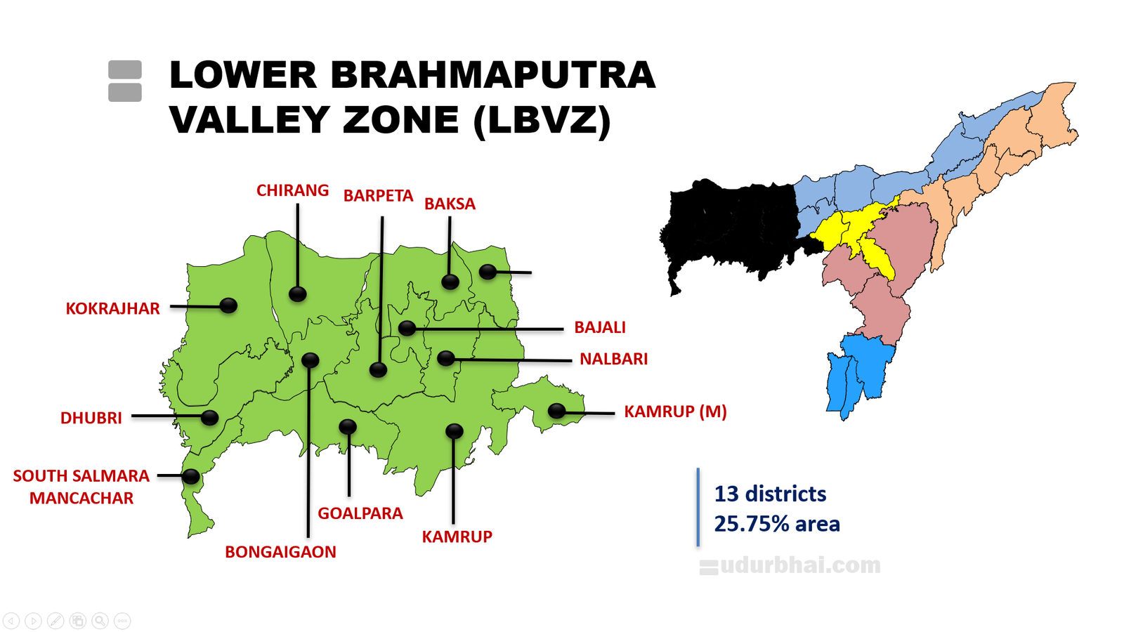
4. Lower Brahmaputra Valley Zone (LBVZ)
Location
- Covers the lower (western) reaches of the Brahmaputra Valley.
- 13 Districts: Goalpara, Bongaigaon, Barpeta,Bajali, Kamrup, Kamrup(M), Nalbari, Baksa, Chirang, Tamulpur Dhubri, South Salmara-Mankachar, Kokrajhar.
- Covers 25.75% of state’s area
- Terrain: Flat alluvial plains; extensive char (riverine islands); gentle southward slope; low-lying floodplains; some hilly fringes in north (e.g., Chirang, Baksa).
Climatic Characteristics
- Annual Rainfall: Very high; 2000–4000+ mm (e.g., Baksa ~3575 mm, Dhubri ~3264 mm, Bongaigaon ~3219 mm, Barpeta ~2287 mm; average zone ~2500–3500 mm).
- Rainfall Distribution: Intense SW monsoon (June–September); heavy pre-monsoon; high rainy days (120–140+); contributes to severe flooding.
- Temperature: Sub-tropical humid; hot summers (max 30–35°C), mild winters (min 10–20°C).
- Relative Humidity: Very high (especially monsoon); supports dense vegetation but exacerbates waterlogging.
- Key Features: Severe annual floods (Brahmaputra + tributaries like Manas, Pagladiya); flash floods; lower drought risk (SGI decreasing but overall low vulnerability per studies); high moisture but erratic intensity.
Soil Types and Topography
- Topography: Mostly flat alluvial plains; extensive char lands (unstable, seasonal); low-lying with poor drainage; gentle slopes southward.
- Soils: Predominantly deep new alluvial (fertile from Brahmaputra silt); loamy to clay loam/silty loam; high organic matter.
- Characteristics: Good nutrient status (medium N, P, K); slightly acidic to neutral; excellent water retention but prone to waterlogging.
- Variations: Sandy loam in chars; silty in floodplains.
- Soil fertility: High; annual silt deposition boosts productivity.
- Issues: Severe erosion/sand casting in chars; waterlogging/acidity in lowlands; flooding damages soil structure.
Major Crops and Cropping Patterns
- Dominant Crop: Paddy/rice (sali/winter rice major; ahu/autumn, boro/summer also grown); covers large cropped area; flood-tolerant varieties essential.
- Other Field Crops: Jute (significant in western districts), pulses (black gram), oilseeds (rapeseed-mustard), maize, groundnut.
- Horticulture: Pineapple, banana, betel nut, vegetables; spices (chilli, ginger limited).
- Cropping Intensity: Moderate; rainfed dominant; potential for rabi in better-drained areas.
- Special: Char cultivation (pulses, oilseeds, vegetables on stable chars); jute prominent; betel nut/arecanut in pockets.
Major Farming Systems and Constraints
- Major Systems: Rice-based mono-cropping; rice + jute/pulses; integrated (crops + fishery in chars/lowlands); horticulture in uplands, intensive cultivation in densely populated regions.
- Constraints:
- Severe annual floods/erosion (60%+ area vulnerable); char instability limits permanent cropping.
- High rainfed dependence; waterlogging delays sowing/harvesting.
- Pests/diseases (e.g., higher fungal incidence like blast in humid conditions).
- Low irrigation; soil degradation from sand casting.
- Climate vulnerabilities: High flood risk; moderate drought pockets; increasing erratic rainfall.
- Vulnerabilities: Among highest flood-prone zones; climate change intensifies flooding.
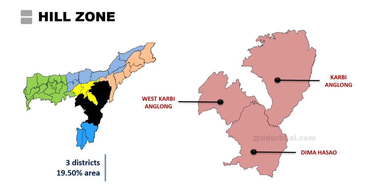
5. Hill Zone
Location
- Covers the hill districts and plateaus in southern/central Assam.
- 3 Districts: Karbi Anglong, West Karbi Anglong, Dima Hasao (formerly North Cachar Hills).
- Covers 19.50% of state’s area
- Terrain: Steep hills, plateaus (e.g., Karbi Anglong plateau/Mikir Hills), valleys; elevations 150–1,360+ m; rugged with dense forests.
Climatic Characteristics
- Annual Rainfall: High; >3000 mm in many areas (e.g., ~2416 mm average in Karbi Anglong plateau; influenced by SW monsoon and orographic effects).
- Rainfall Distribution: Heavy SW monsoon (June–September); intense rains leading to runoff; drier winter/post-monsoon periods.
- Temperature: Sub-tropical to temperate in higher elevations; cooler than plains (salubrious climate); summers warm-humid, winters mild-cool.
- Relative Humidity: High; supports lush vegetation.
- Key Features: Frequent landslides; high humidity; moderate drought trends ; climate salubrious compared to humid plains.
Soil Types and Topography
- Topography: Steep slopes, hills, plateaus; high erosion risk; undulating with valleys.
- Soils: Predominantly red, yellow, reddish-brown, lateritic (uplands); acidic (pH often higher/less acidic than plains in some reports, but generally acidic 4.5–5.8 range); low to medium fertility.
- Characteristics: Medium P₂O₅ status (better than some plain zones); low N, K in patches; prone to erosion and nutrient leaching on slopes.
- Variations: Red loamy in hills; less fertile than alluvial plains.
- Soil fertility: Moderate; requires organic amendments; shifting cultivation depletes fertility over cycles.
- Issues: Severe soil erosion; acidity; low nutrient retention on slopes; aluminum toxicity sporadic.
Major Crops and Cropping Patterns
- Dominant Crop: Upland rice (direct-seeded/jhum rice); maize.
- Other Field Crops: Potato, hill sesame (Sesamum indicum), pulses, oilseeds; ginger, turmeric (spices prominent).
- Horticulture: Pineapple, orange, passion fruit, banana, papaya, litchi; plantation crops (tea, rubber in suitable pockets).
- Cropping Intensity: Low to moderate; jhum dominant (shifting cultivation with long fallows 2–10+ years).
- Special: Jhum/agroforestry systems (crops + trees like tree bean, orange, banana in fallows); market-oriented spices/horticulture emerging.
Major Farming Systems and Constraints
- Major Systems: Shifting cultivation (jhum) dominant (rice + maize + vegetables + fallow regeneration); agroforestry; settled horticulture/plantation in valleys; integrated (crops + livestock like hill goats, piggery + fishery limited).
- Constraints:
- Steep slopes → severe soil erosion and landslides.
- Shifting cultivation → fertility decline, deforestation, biodiversity loss; shortening fallow cycles due to population pressure.
- Low irrigation; rainfed dependence; poor market access in remote hills.
- Pests/diseases in humid conditions; wildlife damage.
- Climate vulnerabilities: Declining rainfall trends (moderate drought risk); increasing landslides; climate change impacts on jhum.
- Vulnerabilities: High erosion; moderate drought risk (HR category in studies); transition from jhum challenging.
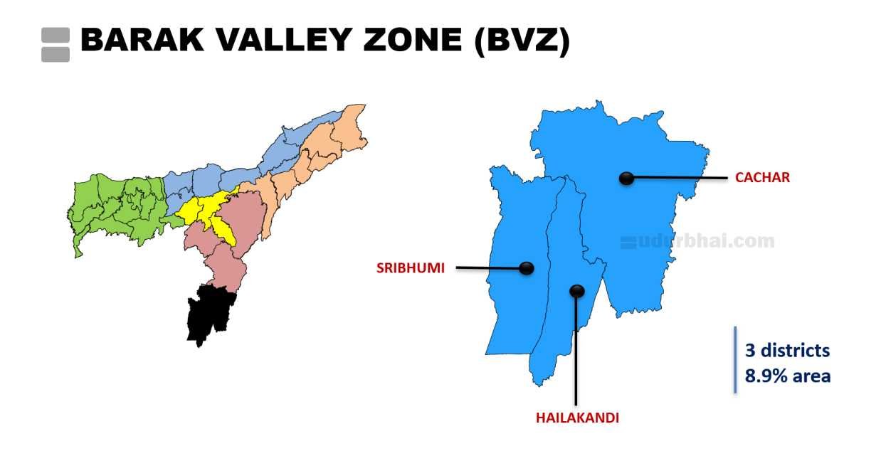
6. Barak Valley Zone (BVZ)
Location
- Covers the Barak Valley region in southern Assam.
- 3 Districts: Cachar, Sribhumi, Hailakandi.
- Covers 8.9% of state’s area
- Terrain: Fertile plains along Barak River and tributaries; low-lying areas; some undulating/hilly fringes (e.g., southern parts); riverine floodplains.
Climatic Characteristics
- Annual Rainfall: Very high; 2500–4000+ mm (e.g., Cachar ~3020 mm with 146 rainy days; Karimganj ~4073 mm average; Hailakandi ~2500+ mm; zone overall 3000–4000 mm).
- Rainfall Distribution: Intense SW monsoon (June–September); heavy pre-monsoon; high rainy days (120–150+); short concentrated rainy period interspersed with dry spells.
- Temperature: Sub-tropical warm-humid; hot summers (max 30–35°C), mild winters (min 10–20°C); high humidity year-round.
- Relative Humidity: Very high; influenced by Bay of Bengal moisture-laden winds.
- Key Features: Flash floods common (e.g., major floods in 1986, 1991, 2004); high moisture favours pests/diseases; low drought risk.
Soil Types and Topography
- Topography: Mostly flat to gently undulating plains; fertile along Barak River; some hilly/undulating in fringes.
- Soils: Mix of red lateritic (uplands/hills) and alluvial (plains/riverine); sandy loam to silty loam/clay.
- Characteristics: Acidic (pH 4.6–5.7, often 4.9–5.3); medium fertility; good for rice/horticulture with amendments.
- Variations: Alluvial in lowlands (fertile, nutrient-rich); lateritic in uplands (less fertile, needs lime/organic matter).
- Soil fertility: Moderate to high in plains; acidity limits some crops (requires amendments like lime).
- Issues: Acidity; waterlogging in lowlands; erosion in hilly fringes; flood damage.
Major Crops and Cropping Patterns
- Dominant Crop: Paddy/rice (sali/winter rice major; ahu/autumn, boro/summer); flood-tolerant varieties common.
- Plantation Crops: Tea (significant); betel vine (paan), arecanut, coconut.
- Other Field Crops: Pulses (rajmah, black gram), oilseeds, jute (limited), vegetables.
- Horticulture: Pineapple, banana, citrus (orange), papaya, vegetables; spices (chilli, ginger, turmeric).
- Cropping Intensity: Moderate; rainfed dominant; potential for double cropping in medium lands.
- Special: Betel vine prominent; green manuring (e.g., dhaincha before sali rice); shifting cultivation (jhum) in hilly fringes (fallow 2–10 years; species like orange, banana, betel leaf, tree bean in fallows).
Major Farming Systems and Constraints
- Major Systems: Rice-based mono-cropping; rice + pulses/vegetables; tea/betel vine plantation; integrated (crops + horticulture + livestock); shifting cultivation in forest villages/hilly parts (transitioning to agroforestry/commercial fallow use).
- Constraints:
- Flash floods/waterlogging; high humidity → pests/diseases (e.g., blast, sheath blight in rice).
- Acidic soils requiring amendments; low mechanization.
- Rainfed dependence; erratic intense rainfall.
- Shifting cultivation pressure on forests; weed infestation/fertility loss in jhum.
- Climate vulnerabilities: high flood risk.
- Vulnerabilities: High flood proneness; moderate climate change impacts (reduced rainfall trends).