
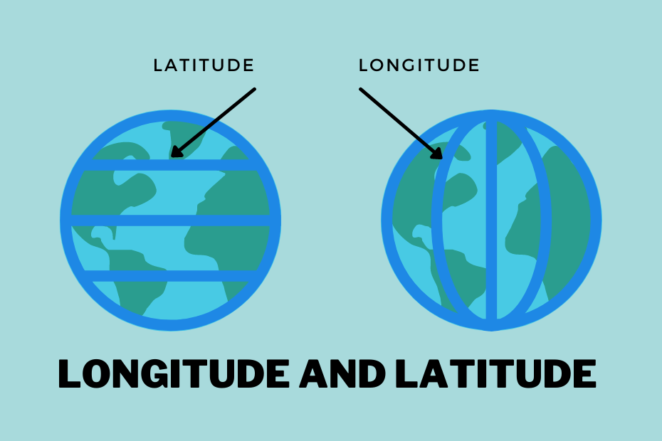
Latitudes and longitudes are imaginary lines drawn on Earth’s surface to precisely determine the location of any place.
Latitudes
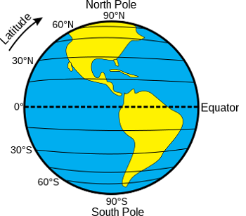
Latitudes are horizontal lines (east-west circles) that measure the distance north or south of the Equator. They are also called parallels because they remain parallel to each other.
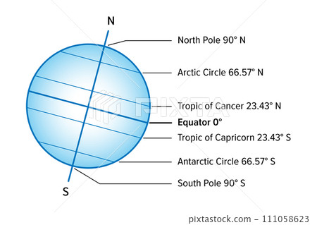
- The Equator is 0° latitude, stretching from east to west around Earth.
- Latitude lines extend from the Equator to 90° North (North Pole) and 90° South (South Pole).
- If drawn at 1° intervals, each hemisphere has 89 latitude lines, totaling 179 lines worldwide.
- Distance between two consecutive latitude lines is approximately 111 km.
Latitudes
Major Parallels of Latitudes
- Equator
- Divides Earth into Northern and Southern Hemispheres.
- Longest line of latitude: 40,075 km, with 78.8% water and 21.3% land.
- Countries on the Equator:
- South America: Ecuador, Colombia, Brazil
- Africa: Gabon, Republic of the Congo, Democratic Republic of the Congo, Uganda, Kenya, Somalia, Sao Tome and Principe
- Asia/Oceania: Maldives, Indonesia, Kiribati

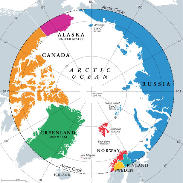
- Arctic Circle
- Northernmost parallel at 66½° N.
- Slowly drifting north at 14.5 meters/year.
- Length: 16,000 km, covering 4% of Earth’s surface.
- The Arctic Circle (approx. 66.5° N) passes through eight countries: Norway, Sweden, Finland, Russia, the United States (Alaska), Canada, Denmark (Greenland), and Iceland
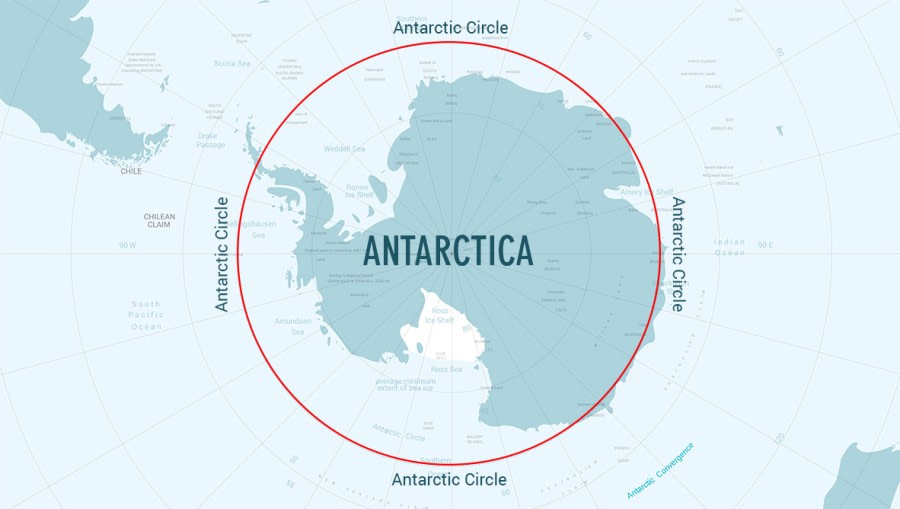
- Antarctic Circle
- Southernmost parallel at 66½° S.
- Shifts southward at about 14.5 meters/year.
- Length: 16,000 km, also covering 4% of Earth’s surface.
- The Antarctic Circle pass through the continent of Antarctica.
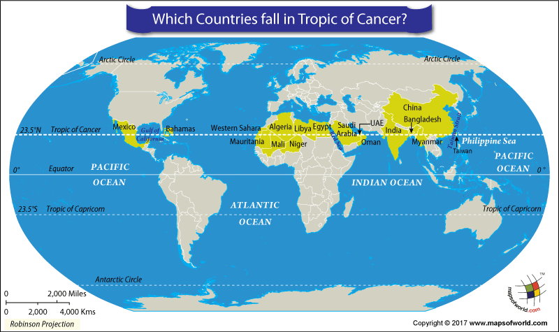
- Tropic of Cancer
- Northern Tropic at 23½° N.
- Sun is directly overhead here in June.
- Length: 36,788 km.
- The Tropic of Cancer passes through 17 countries across North America, Africa, and Asia
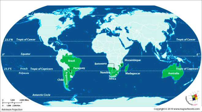
- Tropic of Capricorn
- Southern Tropic at 23½° S.
- Sun is directly overhead in December, experiencing maximum heat.
- Length: Same as Tropic of Cancer, covers 3% of world population.
- The Tropic of Capricorn passes through 10 countries across South America, Africa, and Australia, as well as three oceans (Indian, Atlantic, Pacific).
latitudes on the Earth
Geographical Zones on Earth
Earth’s climate zones are determined by latitude. The five major parallels help define three zones:
Frigid Zones
- North Frigid Zone: Between North Pole and Arctic Circle.
- South Frigid Zone: Between South Pole and Antarctic Circle.
- Coldest regions; experience midnight sun and polar nights.
- Summers last 2–3 months with 24-hour daylight.
Temperate Zones
- North Temperate Zone: Between Arctic Circle and Tropic of Cancer.
- South Temperate Zone: Between Antarctic Circle and Tropic of Capricorn.
- Sun rays never strike directly, resulting in mild weather.
- Experience all four seasons: spring, summer, autumn, winter.
Torrid Zone
- Lies between Tropic of Cancer and Tropic of Capricorn.
- Sun is overhead seasonally, resulting in maximum heat.
Torrid, Temperate and Frigid zone
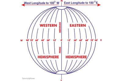
Longitudes
Longitudes are vertical lines (north-south) measuring distance east or west of the Prime Meridian.
- East longitudes: 180 vertical lines east of the Prime Meridian.
- West longitudes: 180 vertical lines west of the Prime Meridian.
East and west longitudes
Prime Meridian
- Passes through Greenwich, UK.
- Defined as 0° longitude and the starting point for measuring time.
- Divides Earth into Eastern and Western Hemispheres.
Eastern Hemisphere
- East of the Prime Meridian.
- Includes Africa, Asia, Europe, Australia, and Oceania islands.
- Contains 80% of the world’s population.
- Also called the Oriental Hemisphere.
Western Hemisphere
- West of the Prime Meridian.
- Covers North and South America, and parts of Africa, Europe, Antarctica, and Asia.
- Centered around the Pacific Ocean, near Genovesa Island.

Longitude and Time
- Earth takes 24 hours to rotate once.
- Sun takes 12 hours to move across Eastern and Western Hemispheres.
- Sun crosses 15° of longitude per hour, equating to 4 minutes per degree.
- To maintain uniform time within a country, the central meridian is taken as standard time.
- There are 24 time zones, each covering 15° of longitude.
- International Date Line (IDL): Passes at 180° longitude, with a 12-hour difference from Greenwich.
Standard Time and Time Zones
- Local time varies if each town followed its own meridian.
- Standard time prevents confusion and helps synchronize schedules across a country.
- Example: In India, the 82½° E longitude is the Indian Standard Time (IST), 5 hours 30 minutes ahead of GMT.
- Large countries like USA, Canada, and Russia have multiple time zones:
- USA & Canada: 5 zones – Atlantic, Eastern, Central, Mountain, Pacific
- Russia (formerly USSR): 11 zones; now 9 zones

Indian Standard Time (IST)
- Based on 82.5° E longitude.
- Standardizes time across India, avoiding regional differences like the 1 hour 45 minutes gap between Dwarka and Dibrugarh.
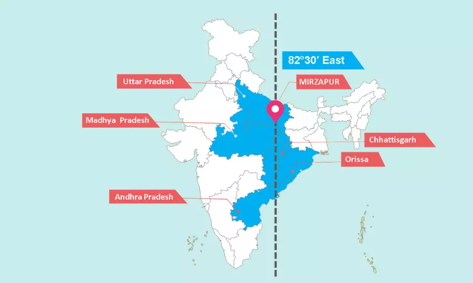
Indian Standard Time passes through 5 States
International Date Line (IDL)
- Travelers eastwards gain time until 180°E, reaching 12 hours ahead of GMT.
- Travelers westwards lose 12 hours until 180°W.
- Crossing IDL changes the date by one day:
- East to west: lose a day
- West to east: gain a day
- IDL is drawn in a zigzag manner to avoid splitting land and island groups, following mostly sea areas.

International Date Line