Sivasagar District

District Overview: Sivasagar District

    • Location: Northeastern Assam, India.
    • Historical Significance: Once the capital of the Ahom kingdom, Sivasagar is famous for its rich cultural heritage, archaeological sites, and natural beauty.
    • Established: September 15, 1989.
    • Importance: Known for its tourism and agriculture, including tea cultivation and oil fields.

Historical Overview of Sivasagar

Early History and Names:

    • Formerly known as Rangpur, earlier called Meteka.

    • Originally named Sibpur, later known as Sivasagar.

    • Believed to have been called ‘Kalansupar’, after Kalansu Gohain, who lived in the area.

    • Bordered by Cherekapar (East), Kathpar (West), Joyrapar (North), and Dhuliapar (South).

British Rule:

    • Treaty of Yandaboo (1826) ended Ahom rule and led to British occupation of Assam.

    • Sibpur and Rangpur were renamed Sibsagar under British administration.

    • Sibsagar district initially included Sibsagar, Jorhat, and Golaghat sub-divisions.

    • 1912: District headquarters shifted to Jorhat, making Sibsagar a sub-divisional headquarters.

    • July 1, 1983: Sibsagar and Golaghat declared separate districts.

Monuments and Structures:

    • Joysagar Tank: Built in 45 days by Rudra Singha (1696-1714) in memory of Joymoti Konwari.

    • Rang Ghar: Constructed by Pramatta Singha (1744-1751) in 1745.

    • Sivasagar Tank: Excavated by Queen Ambika Devi in 1733.

    • Siva Dol, Vishnu Dol, and Devi Dol: Located on the bank of the Sivasagar Tank.

    • Kareng Ghar (Gargaon): Built by Rajeshwar Singha (1751-1769).


Geography of Sivasagar District

    • Area: Approximately 2,668 square kilometers.
    • Coordinates: Around 26°59′ N latitude and 94°38′ E longitude.
    • Boundaries:
      • North: Borders the Brahmaputra River.
      • South: Shares borders with Nagaland and Arunachal Pradesh.
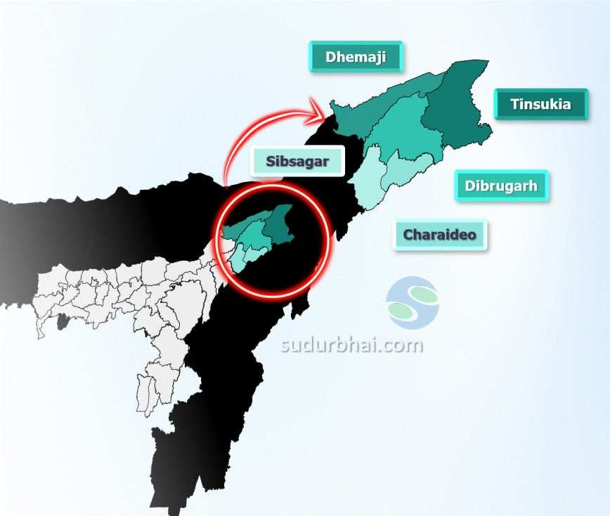
      • East: Adjacent to Dibrugarh district.
      • West: Bordered by Jorhat district.
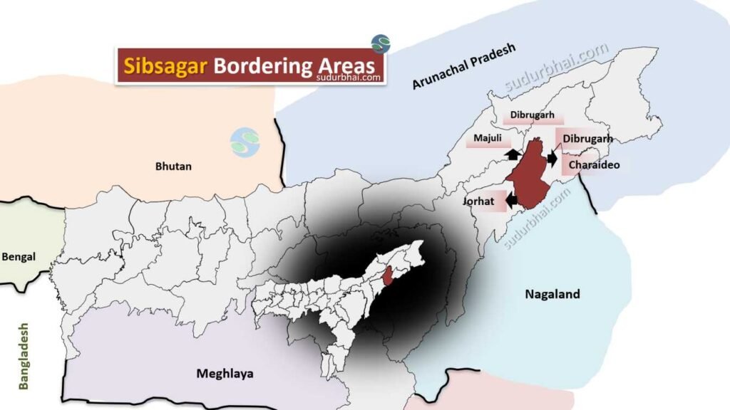
    • Topography: The district is made up of flat plains with low hills and several wetlands and water bodies.
    • Rivers: Major rivers include Brahmaputra, Dikhow, and Kopili.
    • Climate: Humid subtropical climate with an average rainfall of 2,500 mm to 3,000 mm, especially during the monsoon season (June to September).
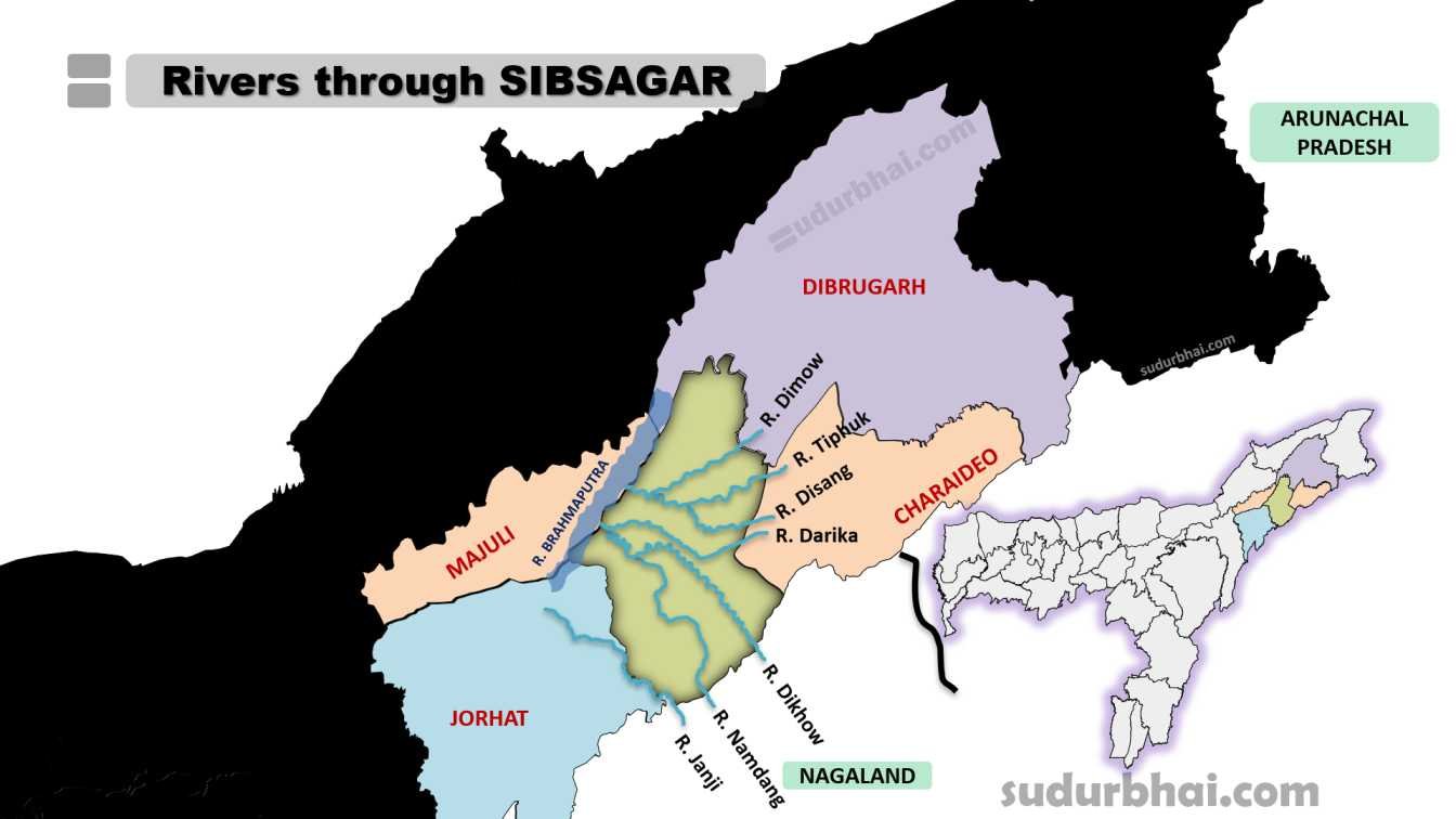
Socio-Economy of Sivasagar District

    • Agriculture: The district’s economy is mainly based on agriculture. Key crops include rice, jute, mustard, tea, and various fruits. The region is known for its tea gardens and oil fields.
    • Livestock: Animal husbandry is also significant, with cattle, goats, and poultry contributing to local livelihoods.
    • Small-scale Industries: Industries in food processing, jute manufacturing, and handicrafts are present, but the industrial sector is still developing.
    • Tourism: Due to its cultural heritage and historical monuments, tourism is an important contributor to the local economy.

Transport in Sivasagar District

    • Roadways: The district is well-connected by National Highway 37, linking it to major cities in Assam.
    • Railways: The nearest railway station is Simaluguri Junction, located about 16 km from the district, providing connections to Assam’s other regions.
    • Airways: The nearest airport is in Jorhat, located about 75 km away, which connects Sivasagar to other parts of India.

Demographics of Sivasagar District

    • Population Overview

      • Total Population (2011): 1,151,050

      • Population Growth Rate (2001-2011): 9.37%

      • Population Density: 431 inhabitants per square kilometer

      Gender Distribution

      • Males: 589,216 (51.19%)

      • Females: 561,834 (48.81%)

      • Sex Ratio: 954 females per 1000 males

      Urban and Rural Population

      • Urban Population: 80,373 (6.97%)

      • Rural Population: 1,070,677 (93.03%)

      Age Distribution

      • Children (0-6 years): 139,380 (12.11%)

        • Males: 71,102

        • Females: 68,278

      • Population aged 7 years and above: 1,011,670 (87.89%)

      Literacy Rate

      • Overall Literacy Rate: 81.36%

        • Male Literacy Rate: Approximately 85.06%

        • Female Literacy Rate: Approximately 73.24%

      Scheduled Castes and Scheduled Tribes

      • Scheduled Castes: 34,704 (5.11%)

      • Scheduled Tribes: 37,130 (5.46%)

      Religious Composition

      • Hinduism: 87.17%

      • Islam: 10.88%

      • Christianity: 1.24%

      • Others/Not Stated: 0.71%


Administrative Setup of Sivasagar District

    • District Headquarters: Sivasagar town.
    • Sub-Divisions: The district is divided into two sub-divisionsSivasagar and Nazira.
    • Revenue Circles: Includes circles like Sivasagar Circle and Nazira Circle.
    • Development Blocks: Several development blocks for local governance and development programs.

Rainfall in Sivasagar District

    • Average Annual Rainfall: Around 2,500 mm to 3,000 mm, with most of the rain falling during the monsoon (June to September).
    • Impact: Heavy rains can cause flooding, but they also help enrich the soil for farming.

Attractive Tourist Places in Sivasagar

    • Talatal Ghar (Rangpur Palace): Originally built as an army base, this monument has three underground floors and two tunnels that functioned as escape routes.

    • Siva Dol Temple: One of the most revered pilgrimage sites in Sivasagar, dedicated to Lord Shiva. Built in 1734 by Bar Raja, it is the largest Shiva temple in Northeast India.

    • Vishnu Dol Temple: A 200-year-old temple dedicated to Lord Vishnu, known for its remarkable architectural beauty.

    • Rang Ghar: Constructed in 1745 by Pramatta Singha, this 18th-century structure served as a royal pavilion for watching sports and games. It is regarded as Asia’s first sports pavilion.

    • Joysagar Tank: Built in 1697 by King Rudra Singha in memory of his mother, this is believed to be India’s largest man-made lake.

    • Kareng Ghar: Constructed by King Rudra Singha, this historical monument served as the military station of the Ahom kings.

    • Sivasagar Tank (Borpukhuri): Dug by Queen Ambika in 1734, this large water body is situated at a higher elevation than the rest of the town.

    • Ahom Museum: A repository of Ahom-era artifacts, including clothing, weapons, manuscripts, goblets, and platters.

    • Charaideo Maidams: Located 28 km from Sivasagar, Charaideo is famous for its Ahom-age tumuli (Maidams). It was the first capital of the Ahoms, established by Sukapha in 1253.

    • Pani Dihing Wildlife Sanctuary: Declared a Wildlife Sanctuary in 1996, this site is renowned for its migratory bird population, attracting numerous nature enthusiasts.


Languages Spoken in Sivasagar District

    • Assamese : 90.24%
    • Mishing : 2.78%
    • Hindi : 1.96%
    • Bengali : 1.58%
    • Sadri : 1.38%

Let us know any further suggestions ,we at sudurbhai.com will be happy to hear from you in our comment section below ! 

Leave a Comment

Your email address will not be published. Required fields are marked *

Scroll to Top