
Majuli District
INDEX
1. District Overview
2. History of Majuli District
3. Geography of Majuli District
4. Socio-Economy of Majuli District
5. Transport in Majuli District
6. Demographics of Majuli District
7. Administrative Setup of Majuli District
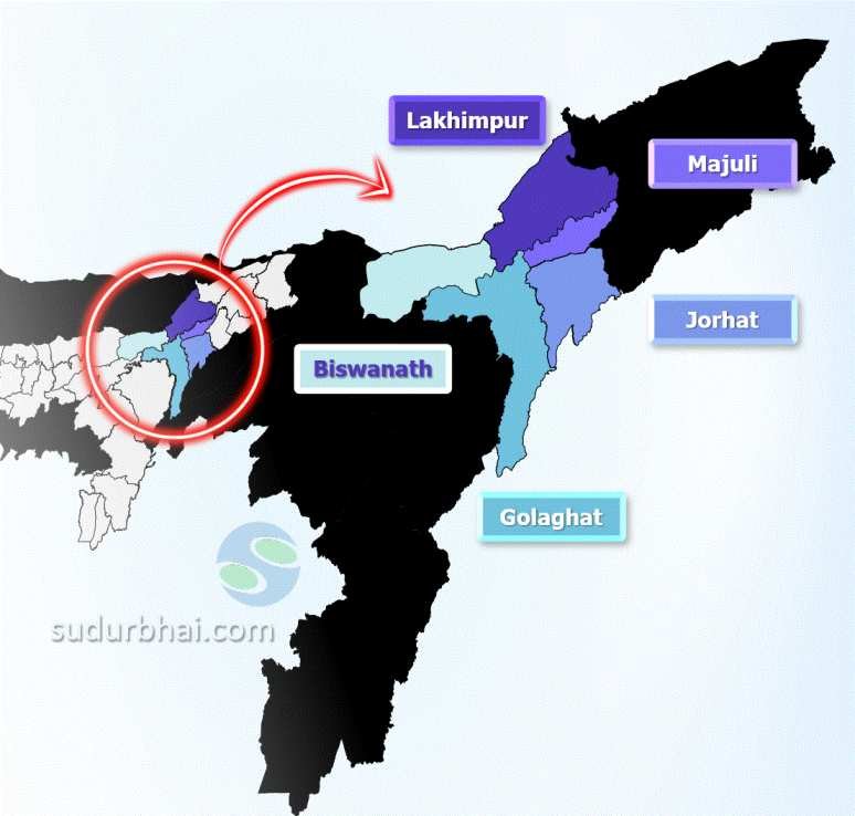
8. Tourist Places in Majuli District
9. Languages Spoken in Majuli District
Table of Contents
ToggleDistrict Overview of Majuli District
- Location: Located in the Brahmaputra River in Assam, India, Majuli is the largest river island in the world.
- Significance: Known for its cultural heritage, biodiversity, and being a center of Assamese Vaishnavism.
- Formation: Majuli became its own district on September 8, 2016, making it the first island district in India.
History of Majuli District
1. Early History and Formation
Geological and Natural Formation
Majuli’s formation is attributed to earthquakes, erosion, and river channel migration over centuries.
The island was originally part of a long, narrow landmass known as Majoli, with the Brahmaputra River to the north and Burhidihing River to the south.
Chutiya Rule (Before the 17th Century)
Around the 16th century, Majuli was known as Ratnapur, the capital of the Chutiya kingdom.
The Chutiyas ruled over this area until they were defeated by the Ahoms in the early 17th century.
Major Natural Events Leading to the Island’s Formation
Between 1661 and 1696, a series of earthquakes altered the river’s course.
A massive flood in 1750 caused the Brahmaputra River to shift, leading to the isolation of Majuli as an island.
2. Ahom Rule and Political Developments
Early Ahom Influence
After annexing the Chutiya kingdom, the Ahoms took control of Majuli in the early 17th century.
Ahom King Pratap Singha built a protective rampart to strengthen the island’s defenses.
Role in the Moamaria Rebellion (1769–1805)
During the Moamaria rebellion, a major uprising against the Ahoms, Majuli became a center of conflict.
A Moamaria rebel leader named Howha controlled the island for a period before the Ahoms reclaimed it.
Ahom Records and Grants
In 1776, Ahom King Lakshmi Singha referred to the region as “Majuli Pradesh” in an official land grant.
British Rule (1826–1947)
The British took control of Assam after the Treaty of Yandabo (1826) and governed Majuli as part of their colonial administration.
The island remained under British control until India’s independence in 1947.
3. Majuli as a Neo-Vaishnavite Cultural Hub
Srimanta Sankardeva’s Influence (15th–16th Century)
Majuli gained prominence as the spiritual center of Neo-Vaishnavism, a reformist Hindu movement led by Srimanta Sankardeva.
Sankardeva, along with his disciple Madhavdeva, established monasteries called satras, which became centers of spiritual learning, performing arts, and Assamese culture.
The first satra in Majuli was founded at Belguri by Srimanta Sankardeva himself.
Growth and Decline of Satras
At its peak, Majuli had 65 satras, which played a crucial role in spreading Vaishnavite philosophy, art, and literature.
Today, due to erosion and socio-political changes, only 22 satras remain active on the island.
4. Modern Developments and District Status
Recognition as an Island District
On September 8, 2016, Majuli was declared a separate district, making it the first island district in India.
This recognition was aimed at preserving its unique cultural heritage and addressing environmental challenges.
Judicial and Administrative Advancements
The S.D.J.M. (Sub-Divisional Judicial Magistrate) Court was established in 1992 to handle local legal matters.
On May 21, 2022, the Majuli District Judiciary was officially inaugurated.
Shri Nogen Senabaya Deori became the first District & Sessions Judge.
Shri Bankim Sharma was appointed the first Chief Judicial Magistrate.
Geography of Majuli District
- Area: Covers 880 square kilometers.
- Boundaries:
- North: Lakhimpur district.
- South: Jorhat and Sibsagar district.
- East: Dibrugarh district.
- West: Golaghat district.
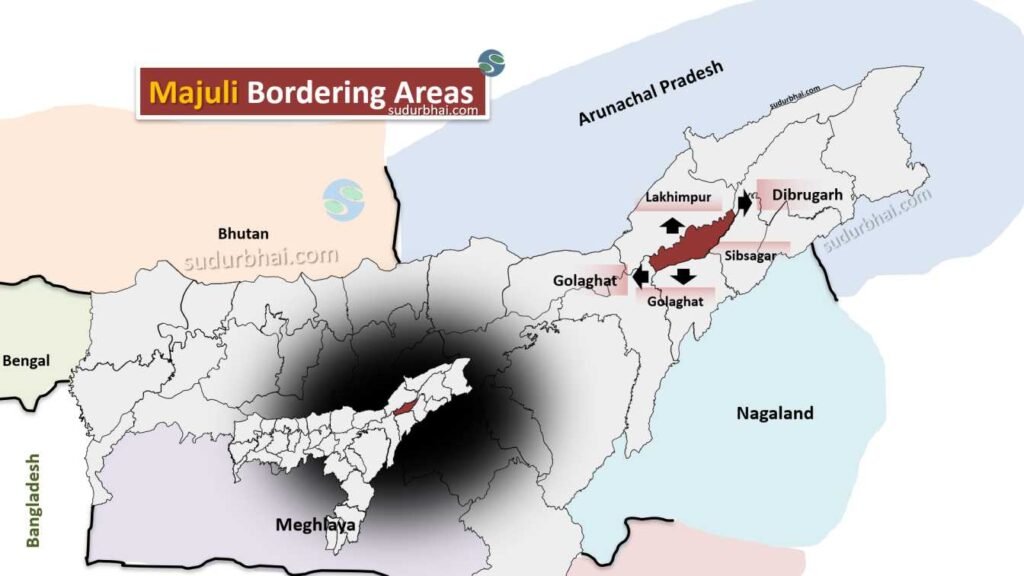
Majuli Neighgbouring Districts
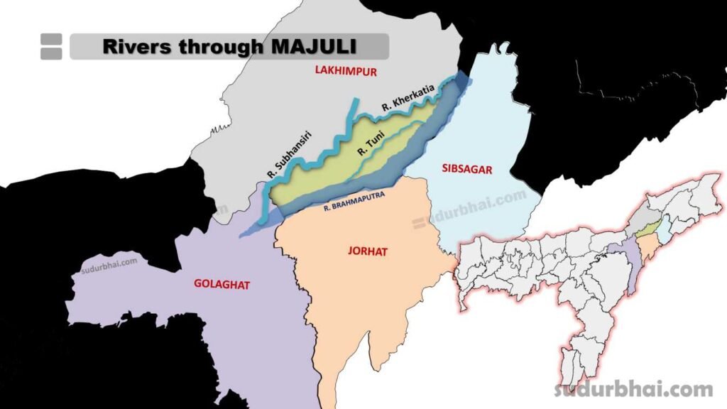
- Topography: Flat alluvial plains and wetlands formed by river sedimentation.
- Climate: Humid subtropical climate with 3,000 mm of annual rainfall, mostly from June to September.
- Rivers: Brahmaputra , Subansiri, Kherkatia and Tuni.
Socio Economy of Majuli District
- Agriculture: Main source of livelihood with crops like rice, jute, mustard, and various fruits. Notable rice varieties include Komal Saul and Bora Saul.
- Handloom and Handicrafts: Weaving of traditional textiles, especially Muga silk and cotton.
- Fishing and Dairying: Fishing in surrounding rivers and dairying are important economic activities.
- Tourism: The district attracts tourists due to its scenic beauty, cultural festivals, and satra monasteries.
Transport of Majuli District
- Roadways: The island is connected to the mainland by ferries from Nimati Ghat in Jorhat.
- Ferries: The main mode of transport to reach Majuli and also used for trade and commuting.
- Airways: The nearest airport is in Jorhat, about 70 km from Majuli.
Demographics of Majuli District
Population
Total Population: 167,304
Entirely rural
Language (as of 2011 census)
Assamese: 54.47%
Mising: 41.01%
Bengali: 1.66%
Deori: 1.22%
Hindi: 0.90%
Nepali: 0.46%
Others: 1.64%
Caste
Scheduled Castes (SC): 14.3%
Scheduled Tribes (ST): 46.4%
Religion
Hinduism: 99.04%
Muslim: 0.35%
Christian: 0.15%
Sikh: 0.01%
Buddhist: 0%
Jain: 0.01%
Other Religion: 0.31%
No Religion Specified: 0.12%
Literacy (Circle data)
Total Literacy Rate: 78.56%
Sex Ratio (Circle data)
Sex Ratio: 955 females per 1000 males
Child Sex Ratio (0-6 years): 948
Children (Age 0-6 years)
Constitute 13% of the total population
Administrative Setup of Majuli District
- District Headquarters: Located in Garamur.
- Sub-Divisions: The district has one sub-division – Majuli.
- Revenue Circles: Two revenue circles – Majuli Circle and Kamalabari Circle.
- Development Blocks: Two development blocks for local governance.
Attractive Tourist places of Majuli District
- Kamalabari Satra: A prominent center of art, culture, and literature with beautiful architecture and intricate designs depicting Assamese culture
- Dakhinpat Satra: A historical monument established in 1584, known for its aesthetic architecture, paintings, and sculptures. It hosts the annual ‘Rasleela’ festival, depicting the life of Lord Krishna
- Auniati Satra: Known for its collection of Assamese artifacts, jewelry, and utensils. It features lion statues at the gateway and serves as an epicenter of Vaishnavism and Satriya culture
- Garmur: A prominent cultural and historical center known for its ancient Satras (monasteries)
- Tengapania: A golden temple-like structure representing Ahom architecture with exquisite statues and pointed pillars, located near the Brahmaputra River with affluent greenery
- Samaguri Satra: Known for mask-making
- Mishing Village: To experience the culture and traditions of the local Mishing tribe
Languages spoken in Majuli District
- Assamese: 54.47%
- Mising: 41.01%
- Bengali: 1.66%
- Deori: 1.22%
Let us know any further suggestions ,we at sudurbhai.com will be happy to hear from you in our comment section below !