
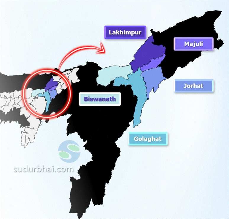
Lakhimpur District
INDEX
1. District Overview
2. History of Lakhimpur District
3. Geography of Lakhimpur District
4. Socio-Economy of Lakhimpur District
5. Transport in Lakhimpur District
6. Demographics of Lakhimpur District
7. Administrative Setup of Lakhimpur District
8. Tourist Places in Lakhimpur District
9. Languages Spoken in Lakhimpur District
Table of Contents
ToggleDistrict Overview of Lakhimpur District
- Location: Situated in the northeastern corner of Assam, India.
- Importance: Known for its agricultural productivity and cultural diversity, Lakhimpur plays a key role in Assam’s socio-economic landscape.
- Established: Officially formed on October 2, 1971.
History of Lakhimpur District
1. Early History and Rulers
Ancient Migrations and Tribal Settlements
Lakhimpur was one of the primary entry points for tribes migrating from the east into the Brahmaputra Valley.
Various indigenous groups, including the Chutiyas, Kacharis, and Baro-Bhuyans, settled in the region, contributing to its cultural diversity.
Chutiya Rule (Until the 16th Century)
The Chutiya dynasty was one of the dominant rulers in the region for centuries.
They established a powerful kingdom that extended over parts of Upper Assam and Arunachal Pradesh.
The Chutiyas were known for their advanced administration, strong military, and expertise in irrigation and agriculture.
However, by the 16th century, the Chutiya kingdom fell to the Ahoms after a prolonged conflict.
Ahom Rule (16th Century – 19th Century)
After defeating the Chutiyas, the Ahom dynasty took control of Lakhimpur.
To effectively administer the region, the Ahoms created the position of Bhatialia Gohain, a governor responsible for managing local affairs.
The Ahom rulers granted feudal control over parts of Lakhimpur to the Baro-Bhuyans, a group of independent landlords who had assisted in the conquest of the Chutiya and Kachari kingdoms.
Under Ahom rule, Lakhimpur became an integral part of the Paik system, which regulated land revenue and military services.
Origin of the Name “Lakhimpur”
The name “Lakhimpur” has its roots in a Chutiya principality founded by King Lakshminarayan in the 15th century.
The term is derived from:
Lakshmi – The Hindu Goddess of wealth and prosperity.
Pur – Meaning town or settlement.
Over time, the name evolved, and Lakhimpur became the official designation for the district.
2. British Administration (1826–1947)
Anglo-Burmese Conflict and British Control
In the late 18th century, Burmese invasions caused widespread devastation in Lakhimpur and surrounding areas.
In 1826, under the Treaty of Yandabo, the British East India Company expelled the Burmese from Assam and took control of the region.
Early British Rule (1826–1838)
Initially, the British placed parts of Lakhimpur and Sivasagar under the rule of Raja Purandhar Singh, a puppet king who ruled under British supervision.
However, by 1838, the British decided to remove indirect rule and brought the entire region under direct British administration.
Judicial and Administrative Reforms
By 1838–1839, the British established a formal judicial system in Lakhimpur.
British policies introduced revenue collection systems, tea plantations, and railway networks, which transformed the economic landscape of the region.
However, the British administration also faced resistance from local tribes and remnants of Ahom royalty.
3. Post-Independence and Administrative Reorganization
Lakhimpur Frontier Tract (1947–1971)
After India gained independence in 1947, Lakhimpur underwent major territorial changes.
The Lakhimpur Frontier Tract included several areas that are now part of Arunachal Pradesh.
Over time, as Assam’s political boundaries were redefined, the district was reorganized.
Formation of Present-Day Lakhimpur District
Originally, Lakhimpur was a vast district that included the present-day districts of Dibrugarh, Tinsukia, and Dhemaji.
The district’s headquarters were located in Dibrugarh before reorganization.
Major Territorial Changes:
1971:
Dibrugarh was separated from Lakhimpur to form a new district.
The present Lakhimpur district was officially created on October 2, 1971.
1989:
Dhemaji district was carved out of Lakhimpur on October 14, 1989, further reducing its size.
Geography of Lakhimpur District
- Boundaries:
- North: Arunachal Pradesh.
- South: Majuli district.
- East: Dhemaji district.
- West: Biswanath district.
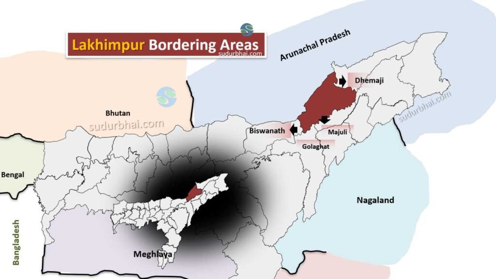
Lakhimpur Neighbouring Districts
- Topography: Mix of flat plains and hilly terrains, with fertile alluvial soil ideal for agriculture.
- Climate: Humid subtropical climate with an average annual rainfall of 3,268 mm during the monsoon season (June to September).
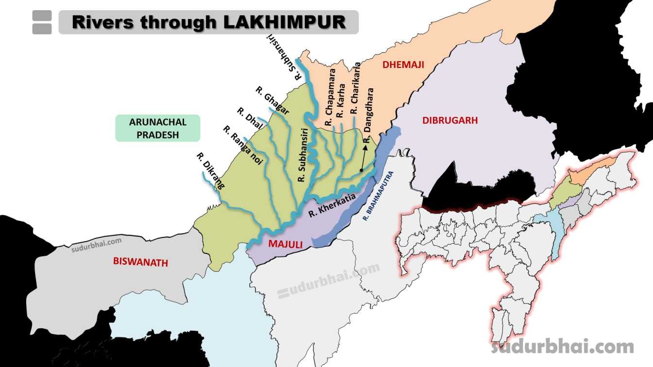
- Rivers: Subansiri, Ghagar , Dhal , Dikrang, Ranga noi and Kherkatia.
- Boundaries:
Socio Economy of Lakhimpur District
- Agriculture: Primary occupation with crops like rice (locally known as “Lakhimi”), jute, mustard, tea, and fruits.
- Livestock: Animal husbandry is common, especially cattle, goats, and poultry.
- Small-Scale Industries: Includes bamboo crafts, weaving, and food processing.
- Trade and Commerce: Lakhimpur serves as a trade center for agricultural products and handicrafts.
Transport of Lakhimpur District
- Roadways: The district is connected by National Highway 15, facilitating travel to other parts of Assam.
- Railways: The nearest railway station is in North Lakhimpur town, connecting to other regions.
- Airways: The nearest airport is in Silchar, about 100 km away from the district.
Demographics of Lakhimpur District
Population
Total Population: 1,042,137
Males: 529,674
Females: 512,463
Rural Population: 91.24%
Urban Population: 8.76%
Population Growth Rate (2001-2011): 17.06%
Density: 457 inhabitants per square kilometre
Literacy
Average Literacy Rate: 77.20%
Male Literacy Rate: 83.52%
Female Literacy Rate: 70.67%
Rural Literacy Rate: 76.22%
Urban Literacy Rate: 86.93%
Sex Ratio
Average Sex Ratio: 968 females per 1000 males
Rural Sex Ratio: 970 females per 1000 males
Urban Sex Ratio: 939 females per 1000 males
Child Population (0-6 years)
Child Population: 15% of the total population
Child Sex Ratio: 959 girls per 1000 boys
Rural Child Sex Ratio: 961 girls per 1000 boys
Urban Child Sex Ratio: 933 girls per 1000 boys
Children in Urban Areas: 11.44% of the urban population
Caste
Scheduled Castes (SC): 7.9% of the total population
Scheduled Tribes (ST): 23.9% of the total population
Administrative Setup of Lakhimpur District
- District Headquarters: North Lakhimpur town.
- Sub-Divisions: Includes North Lakhimpur and Dhakuakhana.
- Revenue Circles: Seven revenue circles across the district.
- Development Blocks: There are nine development blocks focused on local governance and development.
Attractive Tourist places of Lakhimpur District
- Pabha or Milroy Sanctuary: This sanctuary, spanning 49 sq km, was created to protect the wild water buffalo. Visitors may also see elephants and migratory birds
- Bordoibam Bilmukh Wildlife Sanctuary: Located between the Lakhimpur and Dhemaji districts, this sanctuary covers 11.25 sq kms and is home to various bird species and animals like fishing cats and otters
- Leteku Pukhuri: This lake is the birthplace of the famous saint Madhabdev, located 15 km from North Lakhimpur
- Narua Satra: Situated in the northeastern part of Dhakuakhana, this Satra was built by Damodar Aata, the grandson of Srimanta Sankara Deva
- Shri Basudev Than: A well-known ancient temple of Assam
- Phulani Than: Another holy place in Lakhimpur district, located 35 km from North Lakhimpur
- Nahar Ati Than: A temple established in 1528 covering an area of 48 bighas
- Padumoni Than: Located 15 kms away
- Gharmara Satra: An ancient seventeenth-century Vaishnavi spiritual satra
- Moitry Ashram: An ashram based on Gandhian philosophy, established by Vinowa Bhabe
- Buddhist Temple: Located in Narayanpur
- Luit Khaboli: A Mishing tribal village, located 10 kms away from North Lakhimpur, where many migratory birds can be seen
- Joyhing: A place of scenic beauty suitable for picnics
Languages spoken in Lakhimpur District
- Assamese: 57.8%
- Mishing: 17.64%
- Bengali: 12.96%
- Sadri: 2.46%
- Nepali: 2.35%
- Deori: 1.21%
- Hindi: 1.17%
Let us know any further suggestions ,we at sudurbhai.com will be happy to hear from you in our comment section below !