Hailakandi District

District Overview: Hailakandi District

    • Location: Southernmost part of Assam, India.

    • Established: Officially declared as the 24th district of Assam on September 29, 1989.

    • Origin of the Name

      • The name “Hailakandi” may have come from the Kuki language, where “halam” means small state and “kundia” means temporary farmland.

      • Another theory links it to Sailkandi paddy, a rice variety grown in the region, which may have evolved into “Hailakandi.”


History of Hailakandi District

Origin of the Name

    • The name “Hailakandi” may have come from the Kuki language, where “halam” means small state and “kundia” means temporary farmland.

    • Another theory links it to Sailkandi paddy, a rice variety grown in the region, which may have evolved into “Hailakandi.”

Role in India’s Freedom Struggle

    • Hailakandi was involved in the 1857 Sepoy Mutiny, with local fighters resisting British rule at Ron Tila, Mohanpur.

    • Abdul Matlib Mazumdar, a key freedom fighter, worked to unite Hindus and Muslims and opposed India’s partition.

British Rule and Development

    • The British established tea gardens, which boosted the local economy.

    • Railways were built to transport tea, improving connectivity.

    • Several schools and institutions were founded during this period, shaping the district’s education system.


Geography of Hailakandi District

    • Area: 1,327 square kilometers.
    • Coordinates: Between 24°39′ N and 25°08′ N latitude and 92°35′ E and 92°55′ E longitude.
    • Boundaries:
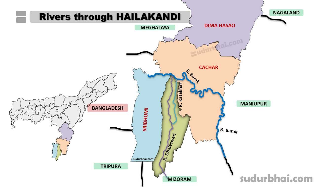
      • North: Cachar district and Barak River.
      • South: Shares boundary with Mizoram.
      • East: Cachar district.
      • West: Sribhumi (Karimganj) district.
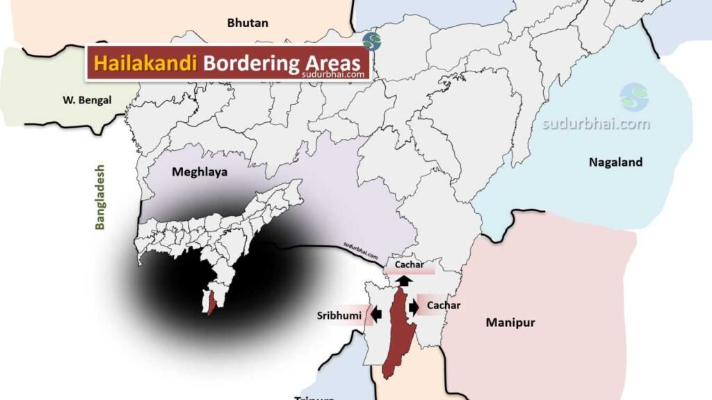
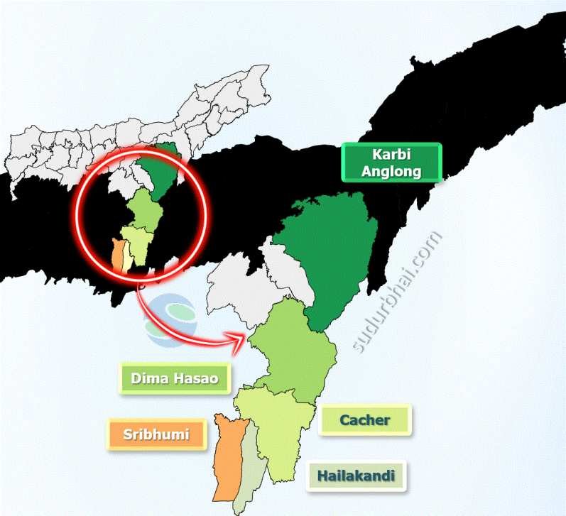
    • Topography: The landscape features hills (locally called tilla), flat plains, and beels (waterlogged areas). The southern part is hilly, while the north is flat.
    • Rivers : Barak River,Dhaleswari River, Katakhal River
    • Climate: Humid subtropical climate with heavy rainfall during monsoon. The average annual rainfall is about 3,000 mm (April to October).

Socio-Economy of Hailakandi District

    • Economy: Primarily agrarian, with agriculture as the main occupation.
    • Major Crops: Rice, jute, mustard, and fruits. Sali paddy is especially significant.
    • Livestock: Cattle, goats, and poultry farming are common.
    • Handicrafts & Small Industries: The district has a tradition of cane and bamboo products. It is relatively industrially backward compared to other regions.
    • Tourism: The district has tourism potential due to its natural beauty and cultural heritage.

Transport in Hailakandi District

    • Roadways: Connected by National Highway 6 linking major towns and cities in Assam.
    • Railways: The nearest railway station is in Hailakandi town, providing connectivity to other parts of Assam.
    • Airways: The closest airport is in Silchar, about 50 km away.

Demographics of Hailakandi District

Population Statistics

    • Total Population: 659,296 (Hailakandi district constitutes about 2.11% of Assam’s total population )

      • Male Population: 337,890 (51.24%)

      • Female Population: 321,406 (48.76%)

Sex Ratio

    • Overall Sex Ratio: 951 females per 1000 males

    • Child Sex Ratio (0-6 years): 954 females per 1000 males

Literacy Rate

    • Overall Literacy Rate: 74.33%

      • Male Literacy Rate: 80.74%

      • Female Literacy Rate: 67.60%

Population Distribution

    • Rural Population: 611,156 (92.70%)

    • Urban Population: 48,140 (7.30%)

Age Distribution

    • Total Child Population (0-6 years): 111,278

      • Male Children (0-6 years): 56,936

      • Female Children (0-6 years): 54,342

    • Child Proportion (0-6 years): 16.88% of total population

Scheduled Castes and Tribes

    • Scheduled Castes: 70,659

    • Scheduled Tribes: 691

Area and Density

        • Geographical Area: 1,327 square kilometers

        • Population Density: Approximately 496 people per square kilometer


Administrative Setup of Hailakandi District

    • Sub-Divisions: Two sub-divisions – Hailakandi and Katlicherra.
    • Revenue Circles: Four revenue circles – Hailakandi, Algapur, Katlicherra, and Lala.
    • Development Blocks: Five development blocks – Algapur, North Hailakandi, South Hailakandi, Lala, and Katlicherra.
    • Administrative Head: The Deputy Commissioner is the administrative head.

Rainfall in Hailakandi District

    • Annual Rainfall: Between 2,500 mm to 3,000 mm.
    • Most rainfall happens during the monsoon (June to October). This heavy rainfall causes flooding in low-lying areas but also enriches the soil.

Attractive Tourist Places

    • Hailakandi Town: Known for its historical significance and local markets.
    • Katlicherra Block: Famous for scenic landscapes and its proximity to Mizoram.
    • Pach Pir Mukam (Pach Pir Dargah) – site featuring the tomb of the Sufi saint Pach Pir.
    • Madhabkunda Waterfall
    • Dawki River (nearby): Known for its crystal-clear waters and picturesque surroundings.
    • Temples & Cultural Sites: Showcasing Assamese traditions.

Languages Spoken in Hailakandi District

    • Bengali: 84.64%

    • Hindi: 7.74%

    • Tiprasa Kachari: 2.11%

    • Manipuri (Meitei): 1.92%

    • Dimasa Kachari: 1.81%

    • Bhojpuri: 1.65%

Let us know any further suggestions ,we at sudurbhai.com will be happy to hear from you in our comment section below ! 

Leave a Comment

Your email address will not be published. Required fields are marked *

Scroll to Top