
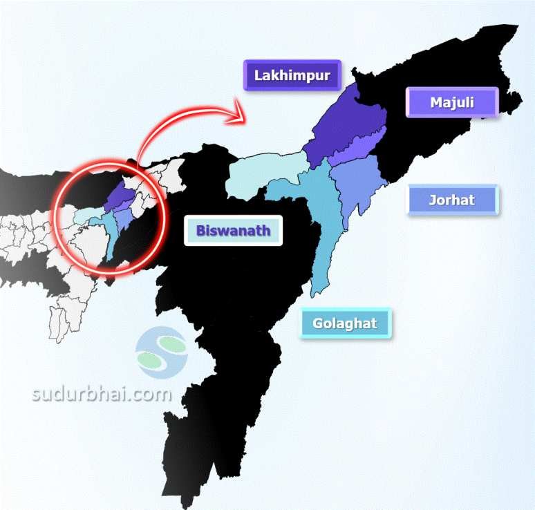
Golaghat District

Golaghat District

  • Location: Upper Assam, India.
  • Established: August 15, 1987.
  • Significance: Known for its rich cultural heritage, agriculture, and historical importance. It’s an important administrative and economic hub.

  History of Golaghat District

1. Early History

    • Ahom Rule (16th Century):
      • Part of Doyang-Dhansiri Valley, ruled by the Ahoms.

      • Ahom King Suhungmung appointed a Marangi-Khowa Gohain to govern the region.

      • Encouraged settlements to maintain control and prevent rebellion.

    • British Annexation (1839–1846):
      • British East India Company took control of Assam.

      • 1839: Region annexed by the British.

      • 1846: Golaghat became a subdivision of Sibsagar district.

2. Development Under British Rule

    • Improved Communication & Infrastructure:
      • 1869: Telegraph lines established.

      • One of Assam’s oldest railway lines built, boosting trade and travel.

    • Administrative Changes:
      • After annexation, Assam was divided into Lakhimpur & Sibsagar districts.

      • Golaghat remained a subdivision under Sibsagar.

3. Post-Independence Era

    • Formation of Golaghat District (1987):
      • Became a separate district on August 15, 1987, carved out from Sibsagar.

    • Cultural Contributions:
      • Played a role in India’s independence movement (Notable freedom fighters: Kushal Konwar & Kamala Miri).

      • Literary impact: Hem Chandra Barua wrote the first Assamese dictionary.

      • Sports: Produced several national athletes.

  Geography of Golaghat District

    • Area: 3,502 square kilometers (1,352 square miles).
    • Boundaries:
      • North: Biswanath and Lakhimpur district.
      • South: Nagaland.
      • East: Jorhat district.
      • West: Karbi Anglong and Nagaon districts.
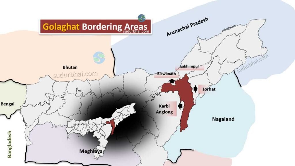
        Golaghat district
        Golaghat neighbouring districts
    • Topography: Mostly flat plains with some hilly areas. Fertile soil supports agriculture.
    • Climate: Humid subtropical climate with annual rainfall ranging from 2,012 mm to 2,249.50 mm. Most rainfall occurs during the monsoon (June to September).
    • Rivers  – Brahmaputra (making Northern borders), Dhansiri , Difalu , Rengma , Kakodonga , Sungajan etc.
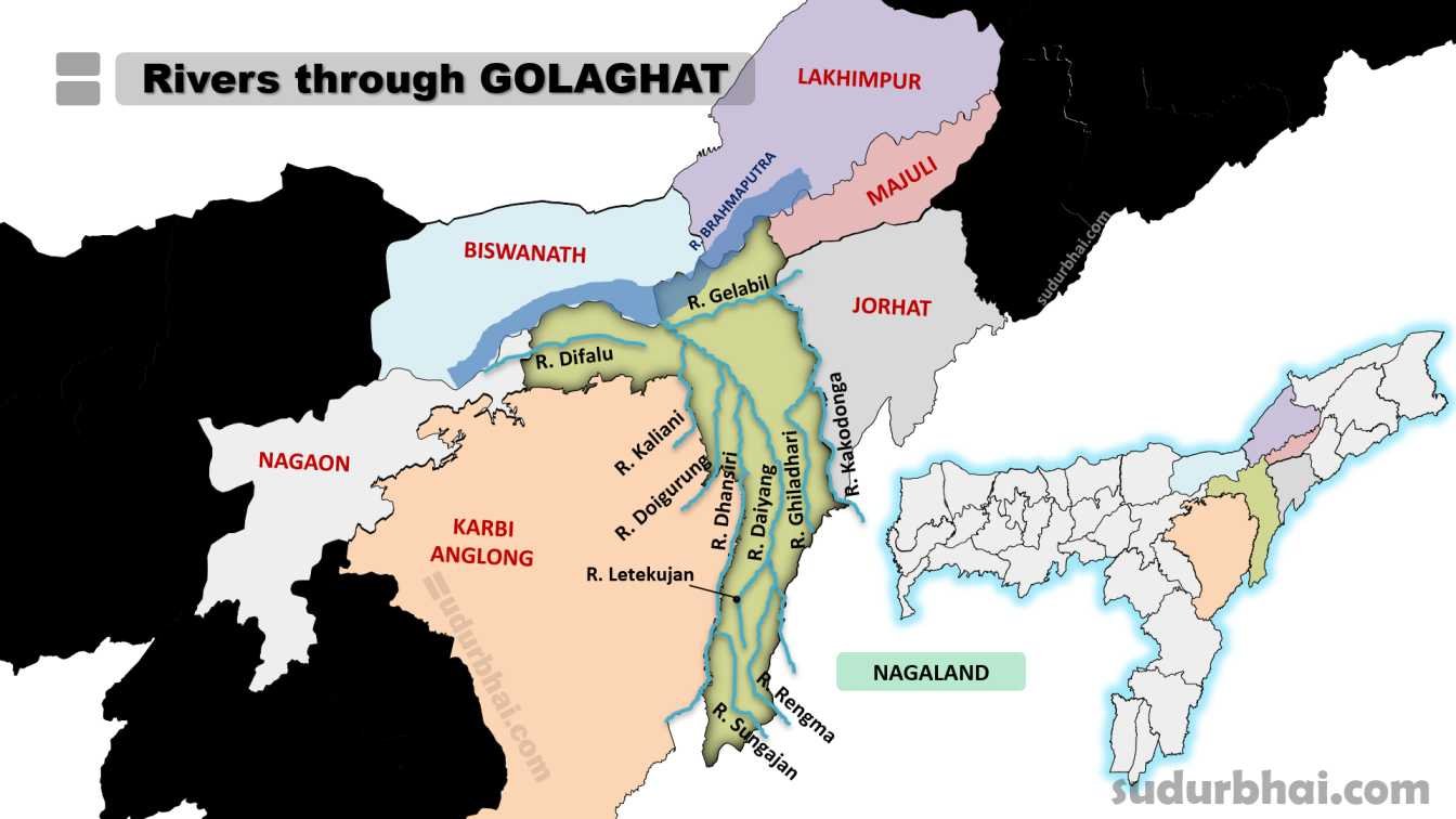
Rivers through Golaghat
Rivers through Golaghat District

  Geography of Golaghat District

    • Area: 3,502 square kilometers (1,352 square miles).
    • Coordinates: 26.52° N latitude and 93.97° E longitude.
    • Boundaries:
      • North: The Brahmaputra River.
      • South: Nagaland.
      • East: Jorhat district.
      • West: Karbi Anglong and Nagaon districts.
    • Topography: Mostly flat plains with some hilly areas. Fertile soil supports agriculture.
    • Rivers flowing through Golaghat – Brahmaputra (making Northern borders), Dhansiri , Diphalu ,Rengma etc.
    • Climate: Humid subtropical climate with annual rainfall ranging from 2,012 mm to 2,249.50 mm. Most rainfall occurs during the monsoon (June to September).

  Socio Economy of Golaghat District

    • Economy: Primarily agrarian, with about 80% of the population engaged in agriculture.
    • Major Crops: Rtea, rice, and sugarcane.
    • Livestock: Includes cattle, goats, and poultry.
    • Small-scale Industries: Cottage industries such as Muga silk reeling, Japi making (traditional headgear), and extraction of Agarwood oil.
    • Numaligarh Oil Refinery is the only major heavy industry in the district, contributing to industrial employment.

  Transport of Golaghat District

    • Roadways: Well-connected by National Highway 37.
    • Railways: The Golaghat Railway Station connects it to other parts of Assam.
    • Airways: The nearest airport is in Jorhat, about 56 km away.

  Demographics of Golaghat District

Population Overview

    • Total Population: 1,066,888

      • Males: 543,161

      • Females: 523,727

    • Average Sex Ratio: 964 females for every 1000 males

    • Population density : 305 persons per sq km.

Urban and Rural Distribution

    • Urban Population: 97,736 (9.16% of total)

      • Male Urban Population: 50,036

      • Female Urban Population: 47,700

      • Urban Sex Ratio: 953

    • Rural Population: 969,152 (90.84% of total)

      • Male Rural Population: 493,125

      • Female Rural Population: 476,027

      • Rural Sex Ratio: 965

Literacy Rates

    • Overall Literacy Rate: 77.43%

      • Male Literacy Rate: 83.56%

      • Female Literacy Rate: 71.09%

    • Urban Literacy Rate:

      • Average: 91.74%

    • Rural Literacy Rate:

      • Average: 75.94%

Child Population (Age 0-6)

    • Total Children (0-6 years): 134,793 (12.63% of total population)

      • Male Children: 68,662

      • Female Children: 66,131

    • Child Sex Ratio (0-6 years): 963 girls for every 1000 boys

Ethnic Composition: Primarily Assamese, Bodos, and other indigenous communities.

 Administrative Setup of Golaghat District

    • Sub-Divisions: Golaghat Sadar, Bokakhat, Dhansiri, and Merapani.
    • Revenue Circles: Six circles, including Golaghat, Bokakhat, and Dergaon.
    • Development Blocks: Eight blocks, including North Dev Block, Morongi South Block, and Padumani Block.
    • Towns: Major towns include Golaghat (Municipal Board), Dergaon, Bokakhat, and Sarupathar.

 Attractive Tourist places of Golaghat District

    • Kaziranga National Park: A UNESCO World Heritage site, home to the Indian one-horned rhinoceros.
    • Sivasagar Sivadol Temple Complex: Historical temples showcasing Assamese architecture.
    • Sri Surya Pahar: An archaeological site with remains of Buddhism and Hinduism.
    • Garampani Hot Springs located in the Nambar Reserve Forest

    • Jugibari Beel: A scenic lake and tourist destination
    • Negheriting Shiva Doul: An ancient temple dedicated to Lord Shiva, located atop a hill offering views of the Brahmaputra River. The temple is surrounded by tea gardens and is a popular picnic spot
    • Uncle Robin’s Children Museum: Showcases personal collections of Dr. Robin, including paintings, dolls, artifacts, and mementos
    • Numaligarh Tea Estate: Offers a beautiful location with nearby forests and hills
    • Deopahar Ruins: An archaeological site with relics of ancient temples amidst greenery, reflecting the region’s history
    • Kakochang Waterfalls: A scenic waterfall near Kaziranga National Park and Bokakhat, surrounded by tea gardens and rubber plantations, ideal for trekking and picnics
    • Srimata Sankardev Udyan: A park dedicated to the saint Srimanta Sankardev, offering well-maintained gardens and a serene atmosphere for relaxation
    • Doigrung Wildlife Sanctuary: Known for diverse species of plants and animals, including elephants and deer. It is a haven for bird watchers and wildlife photographers
    • Birangana Sadhoni Kalakshetra: A cultural center dedicated to preserving and promoting the local culture through dance, music, theatre, and workshops

 Languages spoken in Golaghat District

    • Assamese: 78.40%
    • Bengali: 4.59%
    • Mising: 2.71%
    • Nepali: 2.50%
    • Boro: 1.86%
    • Hindi: 1.79%
    • Sadri: 1.52%
    • Odia: 1.36%

Let us know any further suggestions ,we at sudurbhai.com will be happy to hear from you in our comment section below ! 

Leave a Comment

Your email address will not be published. Required fields are marked *

Scroll to Top