Darrang District
INDEX
1. District Overview
2. History of Darrang District
3. Geography of Darrang District
4. Socio-Economy of Darrang District
5. Transport in Darrang District
6. Demographics of Darrang District
7. Administrative Setup of Darrang District
8. Tourist Places in Darrang District
9. Languages Spoken in Darrang District
District Overview of Darrang District
- Location: Central Assam, India.
- Known For: Rich cultural heritage and historical significance.
- Headquarters: Mangaldoi.

History of Darrang District
Early History
Ancient Kingdoms: Part of the ancient Kamrupa kingdom; ruled by Chutias, Bodo-Kacharies, and Baro-Bhuyans.
Koch Kingdom (16th Century): Incorporated into Koch Hajo under King Nara Narayan.
Ahom Influence (17th Century): Raja Bali Narayan sought Ahom support against the Mughals; after his defeat in 1637, Ahoms took control.
Colonial Period
British Control (1826): Came under British rule after the Treaty of Yandabu.
Administrative Setup: Declared a district in 1833 with Mangaldai as headquarters, later shifted to Tezpur in 1835.
Peasant Uprising (1894): “Battle of Patharughat” – farmers protested high land revenue; British police fired, killing around 140, akin to Jallianwala Bagh.
Post-Independence Developments
District Reorganization (1983): Darrang split into Mangaldai and Sonitpur districts.
Cultural Contributions: Rich in literary and historical heritage; “Darrang Rajvansavali” documents its royal lineage.
Geography of Darrang District
- Area: 1,585 square kilometers (612 square miles).
- Topography: Mostly flat with some hilly areas.
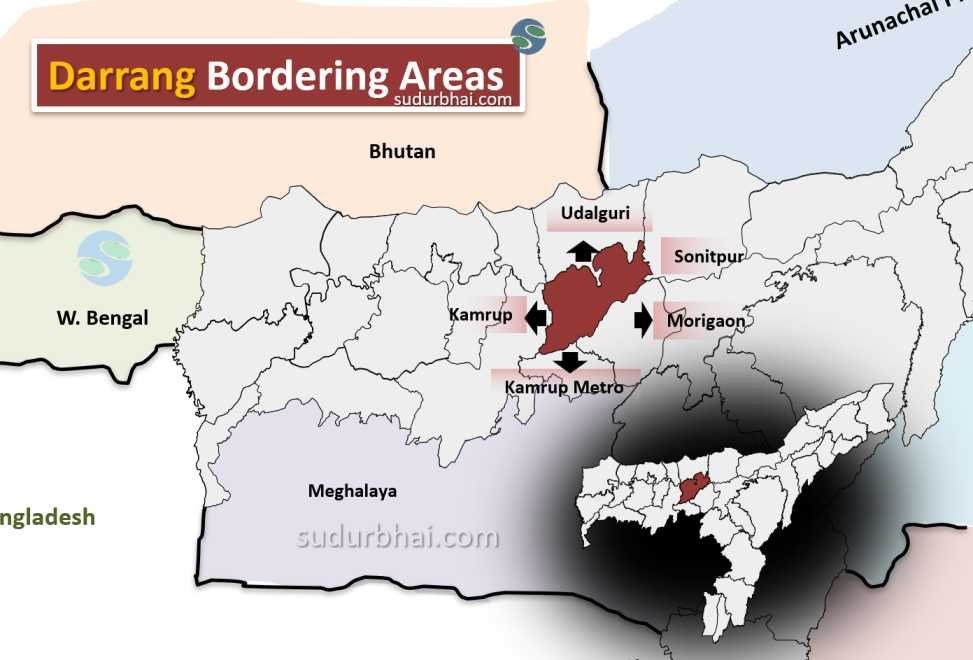
- Borders:
- North : Udalguri
- South : Kamrup (Metro), Morigaon
- East : Sonitpur ,Morigaon
- West : Kamrup
Darrang Neighbouring districts - Rivers: Includes the Brahmaputra, Dhansiri, Bega, and Mangaldoi rivers.
- Climate: Subtropical monsoon climate, ideal for agriculture.
- Annual Rainfall: Ranges from 2,000 mm to 2,500 mm.
- Monsoon: Heavy rainfall occurs mainly from June to September, which supports agriculture.
- Notable Site: Orang National Park (established in 1999) – a wildlife-rich area covering 79 square kilometers.
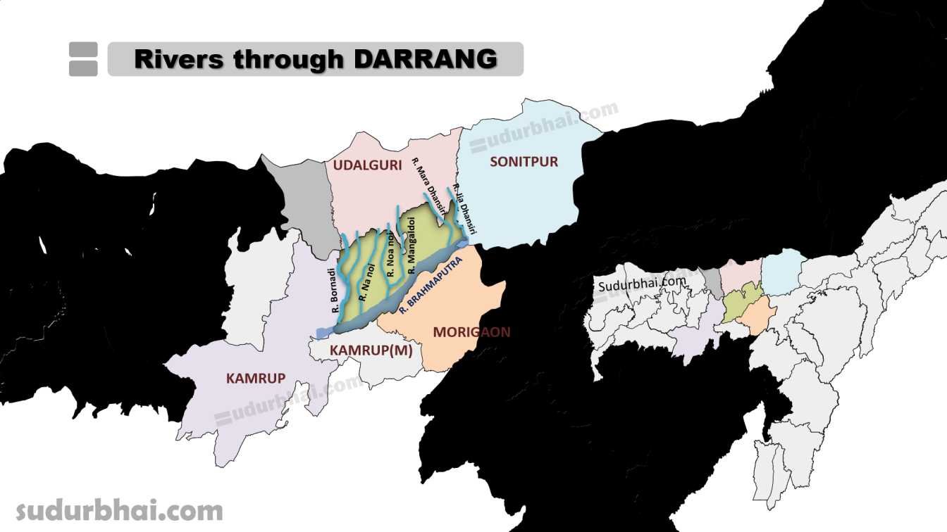
Socio-Economy of Darrang District
- Economy: Primarily agrarian, with key crops like rice, jute, mustard, fruits, and vegetables.
- Industries: Handloom weaving and bamboo crafts have a rich tradition.
- Challenges: High poverty rate (~45.5%) and infrastructure gaps.
- Poverty: A significant portion of the population faces economic difficulties.
Transport of Darrang District
- Main Town: Mangaldoi, a transport hub.
- Railway: The closest railway station to Mangaldoi is Rangiya Junction, which is about 50 km away.
- Public Transport: Buses and auto-rickshaws for local travel.
Demographics of Darrang District
Population Overview
Total Population: 928,500
Male Population: 475,273 (51.2%)
Female Population: 453,227 (48.8%)
Literacy Rate
Overall Literacy Rate: 63.08%
Male Literacy Rate: 67.87%
Female Literacy Rate: 58.04%
Sex Ratio
Overall Sex Ratio: 954 females per 1000 males
Child Sex Ratio (0-6 years): 969 girls per 1000 boys
Religious Composition
Muslims: 64.34% (597,392)
Hindus: 35.25% (327,322)
Christians: 0.18% (1,688)
Others (including Sikhs, Buddhists, Jains): Less than 1%
Urban and Rural Distribution
Rural Population: 94.02% (873,006)
Urban Population: 5.98% (55,494)
Child Population
Total Children (0-6 years): 156,408
Male Children: 79,437
Female Children: 76,971
Administrative Setup of Darrang District
- Established: In 1983.
- Blocks: Six administrative blocks – Mangaldoi, Sipajhar, Dalgaon, Kalaigaon, Khairabari, and Pub-Mangaldai.
- Assembly Constituencies: Four – Mangaldoi, Sipajhar, Dalgaon, and Kalaigaon (Mangaldoi is reserved for Scheduled Castes).
Attractive Tourist Places of Darrang District
Parks and Sanctuaries:
- Orang National Park Also called a “miniature Kaziranga,” it is home to animals like the one-horned rhinoceros, Royal Bengal tiger, and various birds.
- Bornadi Wildlife Sanctuary This is a treat for nature lovers and home to species like the pigmy hogs and the Himalayan black bear.
- Gandhi Smriti Park A lush green park located in the center of Mangaldai town.
Historical Places:
- Patharughat Swaheed Minar A historical site where a large number of people were shot by the police on January 28, 1894.
- Raj Hauli (Palace of the Koch Kings) This palace attracts many tourists, especially during the Durga Puja festival.
Religious Sites:
- Khatara Satra One of the oldest Satras, located 22 km from Mangaldai. Satras are similar to monasteries and unique to Assam, serving as cultural heritage centers.
- Dihing Satra Located 45 km from Mangaldai.
- Narikali Temple of Lord Shiva A religious site for those interested in religious tours.
- Kamakshya Devalaya Near Lakhimpur village, this temple contains a stone fetish with 8 lotus petals on it.
- Bar Masjid One of seven masjids around Mangaldai town.
Other attractions:
- Bhairabkunda A lake near Udalgiri known for its religious significance and beauty.
- Batha Beel Offers bird watching opportunities, as thousands of migratory birds visit.
- Pukhuria Beel Another location for bird watching.
- Baladev Pukhuri A pond created during the reign of King Dharma Narayana, now serving as a government fishery.
- Jaypal Pukhuri A pond created during the reign of King Jaypal, with crystal clear water
Languages Spoken in Darrang District
- Assamese: 49.29%
- Bengali: 48.40%
- Hindi: 0.68%
- Bodo: 0.45%
- Bhojpuri: 0.37%
Let us know any further suggestions ,we at sudurbhai.com will be happy to hear from you in our comment section below !