
The political history of ancient Assam between 350 and 1206 CE represents a formative phase in the development of the region’s state institutions, administrative structures, and cultural identity. During this long period, the powerful kingdom of Kamarupa emerged as the dominant political entity in the Brahmaputra Valley.
The kingdom was ruled successively by three major dynasties:
Varman Dynasty (c. 350–650 CE)
Mlechchha Dynasty (c. 655–900 CE)
Pala Dynasty of Kamarupa (c. 900–1100 CE)
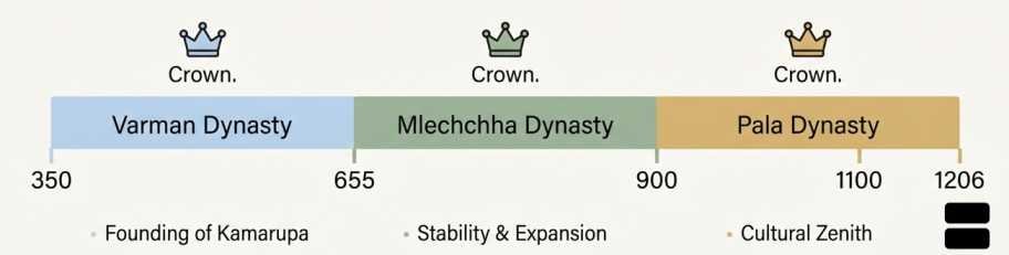
These dynasties established a stable political system, territorial administration, land-grant policies, and diplomatic relations with other Indian kingdoms. Through inscriptions, copperplate grants, and literary texts, historians are able to reconstruct the political organization and governance of ancient Assam.
The period also witnessed the integration of diverse ethnic communities, the expansion of agriculture, and the spread of Brahmanical religious traditions across the region.
Lets understand the political history of ancient Assam through following;
A. Formation of the Kamarupa State
B. Geographic Boundaries of the Kamarupa Kingdom
C. Structure of State Administration
D. Land Grant System and Brahmadeya Settlements
E. Judicial System and Legal Authority of Kamrupa
F. Revenue Records of Kamarupa
G. Administrative Divisions of Kamarupa
H. Political Significance of the Kamarupa Kingdom
Formation of the Kamarupa State
- The formation of the Kamarupa kingdom marks the beginning of recorded political history in Assam.
- The state was founded in the early 4th century CE by Pushyavarman, the first historical ruler of the Varman dynasty.
- Important features of the formation of this kingdom include:
Establishment of centralized monarchical authority
Consolidation of territories across the Brahmaputra Valley
Emergence of Pragjyotishpura (modern Guwahati) as the capital
Development of administrative institutions
- The rise of Kamarupa was likely influenced by the decline of imperial control of the Gupta Empire in eastern India. As the Gupta power weakened, regional rulers like Pushyavarman were able to establish independent kingdoms.
Mythological Legitimacy of Kamarupa Kings
- Like many early Indian dynasties, the rulers of Kamarupa sought to legitimize their authority by claiming divine or legendary ancestry.
- They traced their lineage to figures from Indian mythology, including:
Narakasura
Bhagadatta
- These associations helped the kings:
Strengthen their political legitimacy
Link their kingdom with ancient Indian epic traditions
Enhance their prestige among Brahmanical scholars and religious authorities
- Thus, mythology became an important political tool for legitimizing royal power.
Geographic Boundaries of the Kamarupa Kingdom
- Historical texts and inscriptions describe the territorial extent of the Kamarupa kingdom.
- According to the Yogini Tantra, the kingdom extended:
From the Karatoya River in the west
To the Dikkaravasini shrine near Sadiya in the east
- These boundaries indicate that Kamarupa once controlled a vast region including parts of present-day Assam, North Bengal, and neighboring hill areas.
Epigraphic Evidence of Territorial Boundaries
- Important epigraphic sources confirming the extent of Kamarupa include:
Nidhanpur Copperplate Inscription
Dubi Copperplate Inscription
- These inscriptions recorded:
Royal land grants
Administrative divisions
Genealogies of kings
- They serve as primary historical sources for understanding the political geography of ancient Assam.
Territorial Boundaries of Kamarupa
| Direction | Boundary Landmark |
|---|---|
| West | Karatoya River |
| East | Dikkaravasini Shrine near Sadiya |
| North | Himalayan foothills |
| South | Hill regions of present-day Meghalaya and Karbi Anglong |
These boundaries demonstrate the strategic location and regional influence of Kamarupa in Northeast India.
Structure of State Administration
The rulers of Kamarupa adopted administrative principles derived from ancient Indian political theory.
One important model was the Saptanga Theory of State, described in classical Indian texts like the Arthashastra.
The Saptanga Theory of State
The Saptanga (Seven Limbs) Theory explained the essential components of a functioning state.
| Element | Meaning |
|---|---|
| Swami | The King |
| Amatya | Ministers and advisors |
| Janapada | Territory and population |
| Durga | Fortified capital or defensive structures |
| Kosa | Treasury and financial resources |
| Danda | Army and coercive power |
| Mitra | Allies and diplomatic partners |
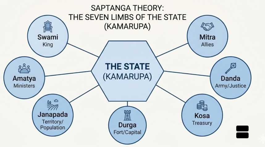
This model shows that governance in Kamarupa was based on well-established political principles of ancient India.
Officials and Administrative Personnel
The administration included a number of officials responsible for governance, diplomacy, and military affairs.
Important officials included:
Mahamatras – high administrative officers
Dutas – diplomatic envoys and messengers
Nayakas – military commanders or local leaders
Bhattarakas – religious authorities and advisors
Mahasandhivigrahikas – ministers responsible for diplomacy and treaties
These officials assisted the king in managing the vast and diverse territories of the kingdom.
Revenue System of Kamarupa
The revenue system formed the economic foundation of the kingdom.
Major sources of revenue included:
| Revenue Source | Description |
|---|---|
| Land Tax | Tax collected from agricultural lands |
| Tributes | Payments from subordinate chiefs |
| Trade Duties | Taxes on commercial goods and trade routes |
Agriculture was the primary economic activity, and therefore land revenue formed the backbone of the state treasury.
Land Grant System and Brahmadeya Settlements
- One of the most important features of the political economy of Kamarupa was the system of land grants.
- Kings frequently issued copperplate inscriptions granting land to:
Brahmins
Temples
Religious institutions
- These grants were called Brahmadeya grants.
Features of Brahmadeya Grants
- Recipients of these grants enjoyed several privileges:
Tax exemptions
Judicial authority within the granted villages
Control over local agricultural production
- These settlements often became centres of:
Religious learning
Sanskrit scholarship
Agricultural development
- Thus, the land grant system served both religious and political purposes.
- It helped:
Spread Brahmanical religion
Expand cultivated land
Integrate remote regions into the state structure
Judicial System and Legal Authority of Kamrupa
- The judicial system of Kamarupa was influenced by Hindu legal traditions, particularly the principles of dharma-shastra.
- Judicial authority operated at several levels:
The King’s Court – the highest judicial authority
Provincial officials – administered justice locally
Brahmin donees – exercised judicial authority in granted villages
- Kings often styled themselves as Dharmapalas, meaning “protectors of law and righteousness.”
- Punishments and legal decisions were based on religious and customary laws.
Revenue Records of Kamarupa
- Revenue officials maintained detailed records concerning:
Taxable land
Boundaries of land grants
Names of cultivators
Agricultural production
- These records ensured efficient tax collection and administrative control.
Administrative Divisions of Kamarupa
The kingdom of Kamarupa had a well-organized territorial administration divided into multiple levels.
These divisions helped the rulers maintain effective control over a large and diverse territory.
Major Administrative Units
| Administrative Unit | Function |
|---|---|
| Bhukti | Large provincial division, possibly ruled by Governor |
| Mandala | Subdivision of Bhukti, often referring to cluster of districts. |
| Vishaya | District-level administrative unit with its ownlocal officers |
| Pura | Urban centre or town with economic or administrative roles |
| Agrahara | Tax-free Brahmin settlement and religious/ educational centre |
| Grama | Village, the basic unit of rural administration |
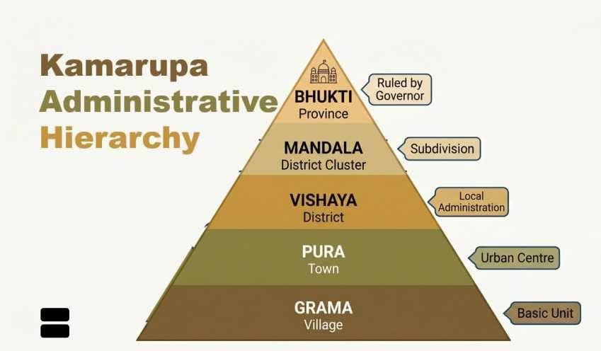
Importance of These Divisions
- This hierarchical system allowed the kingdom to:
Maintain efficient governance
Balance central authority and local autonomy
Facilitate tax collection and administration
Promote religious and cultural institutions
- The village (Grama) formed the foundation of the administrative structure, while higher units ensured coordination at regional levels.
Political Significance of the Kamarupa Kingdom
- The political system developed in ancient Assam between 350 and 1206 CE had several long-lasting impacts:
Establishment of organized monarchy
Development of administrative institutions
Expansion of agriculture and settlements
Spread of Brahmanical culture and Sanskrit learning
Integration of diverse ethnic communities
- These developments laid the historical foundations for later political formations in Assam, including medieval kingdoms.
The political history of ancient Assam during the period 350–1206 CE reflects the gradual evolution of a stable and sophisticated state system.
Through the rule of the Varman, Mlechchha, and Pala dynasties, the kingdom of Kamarupa developed:
A structured administrative hierarchy
A strong revenue system
A network of religious and educational institutions
Effective mechanisms of territorial governance
The political institutions created during this era played a crucial role in shaping the historical identity and cultural development of Assam, leaving behind a legacy preserved in inscriptions, literature, and archaeological remains.